Tocaima
| Tocaima | ||
|---|---|---|
|
Coordinates: 4 ° 27 ′ N , 74 ° 38 ′ W Tocaima on the map of Colombia
|
||
|
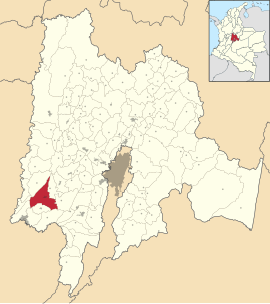
Location of the municipality of Tocaima on the map of Cundinamarca
|
||
| Basic data | ||
| Country | Colombia | |
| Department | Cundinamarca | |
| City foundation | 1544 | |
| Residents | 18,790 (2019) | |
| City insignia | ||
| Detailed data | ||
| surface | 400 km 2 | |
| Population density | 47 inhabitants / km 2 | |
| height | 2668 m | |
| Waters | Río Bogotá | |
| Time zone | UTC -5 | |
| City Presidency | Wilmar Alexander Martínez Bareño (2016–2019) | |
| Website | ||
| Church in Tocaima | ||
Tocaima is a municipality ( municipio ) in the department of Cundinamarca in Colombia . The city is nicknamed Ciudad Salud de Colombia , "City of Health of Colombia".
geography
Tocaima is located at an altitude of about 400 meters about 100 km west of Bogotá exactly in the zone between the Andes and the valley of the Río Magdalena . The average temperature is 28 ° C. The municipality is bordered to the west by Girardot , in the northwest of Nariño and Jerusalén , in the northeast on Apulo , on the east by Viota and on the south by Nilo and Agua de Dios .
population
The municipality of Tocaima has 18,790 inhabitants, of which 11,212 live in the urban part (cabecera municipal) of the municipality (as of 2019).
history
Before the arrival of the Spaniards, the Panches indigenous people lived in what is now Tocaima . The modern Tocaima was 1544 Hernán Vanegas Carrillo under the name of San Dionisio de los Caballeros de Tocaima founded and was the only city in Colombia city rights directly by the Spanish King Carlos V . The place played a role in many important events in the history of Colombia.
economy
The main industries of Tocaima are agriculture and tourism .
Web links
- Alcaldía Municipal de Tocaima. Alcaldía de Tocaima - Cundinamarca, accessed on June 10, 2019 (Spanish, website of the municipality of Tocaima).
Individual evidence
- ↑ a b c Conoce más de nuestro municipio. Alcaldía de Tocaima - Cundinamarca, accessed on June 10, 2019 (Spanish, information on the municipality).
- ↑ ESTIMACIONES DE POBLACIÓN 1985 - 2005 Y PROYECCIONES DE POBLACIÓN 2005 - 2020 TOTAL DEPARTAMENTAL POR ÁREA. (Excel; 1.72 MB) DANE, May 11, 2011, accessed on June 10, 2019 (Spanish, extrapolation of the population of Colombia).


