Hemingbrough
| Hemingbrough | |
|---|---|
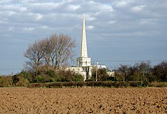
 St Mary's Church, Hemingbrough | |
Location within North Yorkshire | |
| Population | 2,020 (2011 census)[1] |
| Unitary authority | |
| Ceremonial county | |
| Region | |
| Country | England |
| Sovereign state | United Kingdom |
| Post town | SELBY |
| Postcode district | YO8 |
| Police | North Yorkshire |
| Fire | North Yorkshire |
| Ambulance | Yorkshire |
Hemingbrough is a small village and civil parish in North Yorkshire, England that is located approximately 5 miles (8 km) from Selby and 4 miles (6.4 km) from Howden on the A63.[2] It was in the historic East Riding of Yorkshire, but since 1974 has come under North Yorkshire. The village has a 12th-century former collegiate church (Hemingbrough Minster), a Methodist chapel and shops. The village also has a primary school and nursery as well as a playing field for the local children. The surrounding area makes up part of the Humberhead Levels and is flat land mainly used for mixed agriculture. It is thought that from this village came Walter of Hemingbrough, one of Britain's early chroniclers. Writing in the 14th century, he gave us a history beginning with the Norman conquest, now in the British Museum.
Robert de Hemmingburgh, a royal clerk who became Master of the Rolls in Ireland, was born here in the late thirteenth century. Nicholas Bubbewyth, a chancery clerk who became successively, Master of the Rolls, Keeper of the Privy Seal, Lord High Treasurer of England, and Bishop of London, Bishop of Salisbury and Bishop of Bath and Wells, was born in Menthorpe.
In 1989 Caron Keating and Blue Peter visited the village to replace the cockerel on the top of the church spire which had been damaged for several years.
In February 2014, Hemingbrough Parish Council were awarded funds from the Heritage Lottery Fund to help raise awareness of the historical heritage within Hemingbrough Parish to benefit the local community.[3]
History and overview[edit]

The toponym is of uncertain origin. The place is mentioned in the Knýtlinga saga, and the name may be the burh of a Viking named Hemingr. Alternative explanations are that it was the burh of the followers of a man called Hema, or the burh by the fish-weir (Old English hemming).[4]
In the Middle Ages the village was in the Ouse and Derwent wapentake of the East Riding of Yorkshire. At that time the village was on the River Ouse, but at some point the river broke through a meander leaving the village some distance from the river. Hemingbrough was a large parish, and included the townships of Barlby, Osgodby, Cliffe with Lund, South Duffield, Brackenholme with Woodhall and Menthorpe with Bowthorpe. All these townships became separate civil parishes in 1866. In 1935 the civil parish of Hemingbrough absorbed the civil parish of Brackenholme with Woodhall.[5]
In 1974 Hemingbrough was transferred from the East Riding to the new county of North Yorkshire.[6] From 1974 to 2023 was in the Selby District of the shire county of North Yorkshire. In 2023 the district was abolished and North Yorkshire became a unitary authority.
The village holds a very popular summer fete replete with floats on lorries and tractor trailers.[7] There is a memorial garden which the Archbishop of York Dr John Sentamu visited in April 2016.[8]
St Mary the Virgin Church[edit]
The village has a 12th-century church, called St Mary the Virgin, which has served as a Minster to this area until the dissolution of the monasteries. It has a 120 feet (37 m) spire, added in the 15th century, which allows it to dominate the plain. Its importance lies in the woodwork and carvings in the church and it has oldest recorded misericord in the country.[9][10][11]
Governance[edit]
An electoral ward in the same name exists. This ward includes Cliffe and surrounding areas with a total population taken at the 2011 Census of 4,098.[12]
Notable residents[edit]
- Nigel Cumberland - Author, who lived in the village during his schooling years
- Blessed Robert Dalby - English Catholic priest and martyr.
- Jeremiah Smith (Royal Navy officer) (died 1675)[13]
References[edit]
- ^ UK Census (2011). "Local Area Report – Hemingbrough Parish (1170217408)". Nomis. Office for National Statistics. Retrieved 1 October 2018.
- ^ "Site Allocations Development Plan Document - Hemingbrough Designated Service Village" (PDF).
- ^ "Schedule of Decisions under delegated powers to Head of HLF Yorkshire and the Humber" (PDF). 13 February 2014. Archived from the original (PDF) on 26 August 2016.
- ^ Watts, Victor, ed. (2010). "Hemingbrough". The Cambridge Dictionary of English Place-Names. Cambridge University Press.
- ^ Baggs, A. P.; Kent, G. H. R; Purdy, J. D. (1976). Allison, K. J. (ed.). "Hemingbrough". A History of the County of York East Riding: Volume 3, Ouse and Derwent Wapentake, and Part of Harthill Wapentake. Victoria County History. pp. 37–47. Retrieved 16 May 2015.
- ^ "History of Hemingbrough, in Selby and East Riding | Map and description". www.visionofbritain.org.uk. Retrieved 25 November 2020.
- ^ "Domesday Reloaded: Hemingbrough Fete Day, from 1986". BBC. Archived from the original on 20 March 2012. Retrieved 27 May 2016.
- ^ "Latest News | Hemingbrough Historical Heritage Society". Dev.phhhs.org.uk. 6 October 2013. Retrieved 27 May 2016.
- ^ "Hemingbrough Church - St. Mary".
- ^ Historic England (17 November 1966). "Church of St Mary the Virgin - Hemingbrough - North Yorkshire - England (1148462)". National Heritage List for England. Retrieved 30 July 2021.
- ^ "St Mary the Virgin, Hemingbrough". Wasleys.org.uk. Retrieved 27 May 2016.
- ^ UK Census (2011). "Local Area Report – Hemingbrough Ward (as of 2011) (1237325202)". Nomis. Office for National Statistics. Retrieved 1 October 2018.
- ^ "Smith or Smyth, Sir Jeremiah (d. 1675)". Dictionary of National Biography. Vol. Volume 53.
External links[edit]
![]() Media related to Hemingbrough at Wikimedia Commons
Media related to Hemingbrough at Wikimedia Commons

