
Spring Mountains National Recreation Area: Difference between revisions
Vegaswikian (talk | contribs) Sorry, but that sounds like a copyvio. |
replaced dead link |
||
| (24 intermediate revisions by 17 users not shown) | |||
| Line 4: | Line 4: | ||
| photo = |
| photo = |
||
| photo_caption = |
| photo_caption = |
||
| map = USA |
| map = Nevada#USA |
||
| relief = 1 |
|||
| map_caption = |
| map_caption = |
||
| location = [[Clark County, Nevada|Clark]] / [[Nye County, Nevada|Nye]] counties, [[Nevada]], |
| location = [[Clark County, Nevada|Clark]] / [[Nye County, Nevada|Nye]] counties, [[Nevada]], United States |
||
| nearest_city = [[Las Vegas, Nevada]] |
| nearest_city = [[Las Vegas, Nevada]] |
||
| coordinates = {{coord|36|16|18|N|115|41|40|W|region:US|format=dms|display=inline,title}} |
|||
| lat_d = 36 | lat_m = 16 | lat_s = 18 | lat_NS = N |
|||
| long_d = 115 | long_m = 41 | long_s = 40 | long_EW = W |
|||
| region = US |
|||
| coords_ref = |
| coords_ref = |
||
| area = {{convert|316000|acre|sqmi km2||}} |
|||
| area = 316,000 acres (1,279 km<sup>2</sup>) |
|||
| established = August 4, 1993 |
| established = August 4, 1993 |
||
| visitation_num = |
| visitation_num = |
||
| visitation_year = |
| visitation_year = |
||
| governing_body = [[United States Forest Service]] |
| governing_body = [[United States Forest Service]] |
||
| website = [https://www.fs.usda.gov/detail/htnf/about-forest/districts/?cid=fseprd754245 Spring Mountains National Recreation Area] |
|||
}} |
}} |
||
The '''Spring Mountains National Recreation Area''' (SMNRA) is a [[United States|U.S.]] [[ |
The '''Spring Mountains National Recreation Area''' (SMNRA) is a [[United States|U.S.]] [[national recreation area]], administered by the [[U.S. Forest Service]], west of [[Las Vegas, Nevada]]. It covers over {{convert|316000|acre|sqmi km2||}}. The area runs from low meadows (around {{convert|3000|ft|disp=or|sp=us|}} above sea level), to the {{convert|11918|ft|adj=on||}} [[Mount Charleston]]. The SMNRA is a part of the [[Humboldt-Toiyabe National Forest]]. It adjoins the [[Red Rock Canyon National Conservation Area]], which is administered by the [[Bureau of Land Management]]. |
||
Spring Mountains National Recreation Area is home to several plant and animal |
Spring Mountains National Recreation Area is home to several plant and animal species that are [[Threatened species|threatened]]. This was the driving force to create the [[Mount Charleston Wilderness]] area. |
||
The SMNRA offers |
The SMNRA offers activities such as [[hiking]], [[picnicking]], and skiing at the [[Las Vegas Ski and Snowboard Resort]]. |
||
==History== |
==History== |
||
The area was first named the '''Charleston Forest Reserve''' in 1906. |
The area was first named the '''[[Charleston Forest Reserve]]''' in 1906. |
||
Additional land was added in 1989 to bring the area up to the current 316,000+ acres (1,279 km<sup>2</sup>). |
Additional land was added in 1989 to bring the area up to the current 316,000+ acres (1,279 km<sup>2</sup>). |
||
The area was designated as Spring Mountains National Recreation Area by the [[U.S. Congress]] in 1993. |
The area was designated as Spring Mountains National Recreation Area by the [[U.S. Congress]] in 1993. |
||
== Activities<ref>{{Cite web|url=https://www.fs.usda.gov/recarea/htnf/recarea/?recid=65168|title=Spring Mountains National Recreation Area Office|website=USDA Forest Service}}</ref> == |
|||
=== Mountain Biking === |
|||
* Bristlecone Trail |
|||
* Lower Bristlecone Trailhead |
|||
* Sawmill Trailhead |
|||
* Upper Bristlecone Trailhead |
|||
=== Campgrounds === |
|||
* Fletcher View Campground |
|||
* Hilltop Campground |
|||
* Kyle Canyon Road |
|||
* McWilliams Campground |
|||
* Mt. Charleston Scenic Byway |
|||
=== Backpacking === |
|||
* Kyle Canyon Road |
|||
* Mt. Charleston National Recreation Trail (S. Loop) |
|||
* Mt. Charleston Scenic Byway |
|||
* North Loop Trail |
|||
=== Hiking === |
|||
* Bonanza Trail |
|||
* Cathedral Rock Connector Trail |
|||
* Cathedral Rock Trail |
|||
* Cathedral Rock Trailhead |
|||
* Echo Trailhead |
|||
* Fletcher Canyon Trail |
|||
* Fletcher Canyon Trailhead |
|||
* Griffith Peak Trail |
|||
* Griffith Peak Trailhead |
|||
* Kyle Canyon Road |
|||
* Lower Bristlecone Trailhead |
|||
* Mary Jane Falls Trail |
|||
* Mary Jane Trailhead |
|||
* Mt. Charleston National Recreation Trail (S. Loop) |
|||
* Mt. Charleston Scenic Byway |
|||
* North Loop Trail |
|||
* North Loop Trailhead |
|||
* Robbers Roost Trailhead |
|||
* Sawmill Loop Trail |
|||
* Sawmill Ridge Route Trail |
|||
* Sawmill Trailhead |
|||
* Trail Canyon Trail |
|||
* Trail Canyon Trailhead |
|||
* Upper Bristlecone Trail |
|||
* Upper Bristlecone Trailhead |
|||
=== Picnicking === |
|||
* Cathedral Rock Picnic Site |
|||
* Deer Creek Picnic Site |
|||
* Kyle Canyon Picnic Area |
|||
* Kyle Canyon Road |
|||
* Mt. Charleston Scenic Byway |
|||
* Old Mill Picnic Site |
|||
* Sawmill Trailhead |
|||
Areas for Group Picnicking at Spring Mountains National Recreation Area Office |
|||
* Foxtail Group Picnic Site |
|||
* Kyle Canyon Picnic Area |
|||
=== Winter Sports === |
|||
* [[Lee Canyon (Ski and Snowboard Resort)]] |
|||
* Mt. Charleston Scenic Byway |
|||
==Gallery== |
==Gallery== |
||
| Line 37: | Line 109: | ||
File:SpringMountainsTrail.JPG|A hiking trail in the mountains. |
File:SpringMountainsTrail.JPG|A hiking trail in the mountains. |
||
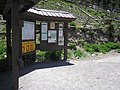
File:SpringMountainsVisitorCenter.JPG|Forest Service sign at the [[Visitor center]] |
File:SpringMountainsVisitorCenter.JPG|Forest Service sign at the [[Visitor center]] |
||
File:Charleston Peak South Loop Trail Sign.jpg|[[Mount Charleston|Charleston Peak]] South Loop Trail Sign |
|||
File:Fall Colors on South Loop Trail to Charleston Peak.jpg|Fall Colors on South Loop Trail to [[Mount Charleston|Charleston Peak]] |
|||
</gallery> |
</gallery> |
||
==References== |
|||
{{Reflist}} |
|||
==External links== |
==External links== |
||
* [ |
* [https://www.fs.usda.gov/detail/htnf/about-forest/districts/?cid=fseprd754245 U.S. Forest Service SMNRA Page] |
||
* [http://www.summitpost.org/route/156610/cathedral-rock.html link to SummitPost description of Cathedral Rock hiking trail ] |
* [http://www.summitpost.org/route/156610/cathedral-rock.html link to SummitPost description of Cathedral Rock hiking trail ] |
||
{{USNRAs}} |
{{USNRAs}} |
||
{{Protected |
{{Protected areas of Nevada}} |
||
{{Las Vegas Valley}} |
|||
{{Authority control}} |
|||
[[Category:Spring Mountains]] |
[[Category:Spring Mountains]] |
||
[[Category: |
[[Category:Humboldt–Toiyabe National Forest]] |
||
[[Category:Protected areas of Clark County, Nevada]] |
[[Category:Protected areas of Clark County, Nevada]] |
||
[[Category:Protected areas of Nye County, Nevada]] |
[[Category:Protected areas of Nye County, Nevada]] |
||
| Line 54: | Line 133: | ||
[[Category:Protected areas of the Great Basin]] |
[[Category:Protected areas of the Great Basin]] |
||
[[Category:Protected areas of the Mojave Desert]] |
[[Category:Protected areas of the Mojave Desert]] |
||
[[Category:Protected areas established in 1993]] |
|||
[[Category:1993 establishments in Nevada]] |
|||
Latest revision as of 03:33, 21 January 2024
| Spring Mountains National Recreation Area | |
|---|---|
IUCN category V (protected landscape/seascape) | |
  | |
| Location | Clark / Nye counties, Nevada, United States |
| Nearest city | Las Vegas, Nevada |
| Coordinates | 36°16′18″N 115°41′40″W / 36.27167°N 115.69444°W |
| Area | 316,000 acres (494 sq mi; 1,280 km2) |
| Established | August 4, 1993 |
| Governing body | United States Forest Service |
| Website | Spring Mountains National Recreation Area |
The Spring Mountains National Recreation Area (SMNRA) is a U.S. national recreation area, administered by the U.S. Forest Service, west of Las Vegas, Nevada. It covers over 316,000 acres (494 sq mi; 1,280 km2). The area runs from low meadows (around 3,000 feet or 910 meters above sea level), to the 11,918-foot (3,633 m) Mount Charleston. The SMNRA is a part of the Humboldt-Toiyabe National Forest. It adjoins the Red Rock Canyon National Conservation Area, which is administered by the Bureau of Land Management.
Spring Mountains National Recreation Area is home to several plant and animal species that are threatened. This was the driving force to create the Mount Charleston Wilderness area.
The SMNRA offers activities such as hiking, picnicking, and skiing at the Las Vegas Ski and Snowboard Resort.
History[edit]
The area was first named the Charleston Forest Reserve in 1906.
Additional land was added in 1989 to bring the area up to the current 316,000+ acres (1,279 km2). The area was designated as Spring Mountains National Recreation Area by the U.S. Congress in 1993.
Activities[1][edit]
Mountain Biking[edit]
- Bristlecone Trail
- Lower Bristlecone Trailhead
- Sawmill Trailhead
- Upper Bristlecone Trailhead
Campgrounds[edit]
- Fletcher View Campground
- Hilltop Campground
- Kyle Canyon Road
- McWilliams Campground
- Mt. Charleston Scenic Byway
Backpacking[edit]
- Kyle Canyon Road
- Mt. Charleston National Recreation Trail (S. Loop)
- Mt. Charleston Scenic Byway
- North Loop Trail
Hiking[edit]
- Bonanza Trail
- Cathedral Rock Connector Trail
- Cathedral Rock Trail
- Cathedral Rock Trailhead
- Echo Trailhead
- Fletcher Canyon Trail
- Fletcher Canyon Trailhead
- Griffith Peak Trail
- Griffith Peak Trailhead
- Kyle Canyon Road
- Lower Bristlecone Trailhead
- Mary Jane Falls Trail
- Mary Jane Trailhead
- Mt. Charleston National Recreation Trail (S. Loop)
- Mt. Charleston Scenic Byway
- North Loop Trail
- North Loop Trailhead
- Robbers Roost Trailhead
- Sawmill Loop Trail
- Sawmill Ridge Route Trail
- Sawmill Trailhead
- Trail Canyon Trail
- Trail Canyon Trailhead
- Upper Bristlecone Trail
- Upper Bristlecone Trailhead
Picnicking[edit]
- Cathedral Rock Picnic Site
- Deer Creek Picnic Site
- Kyle Canyon Picnic Area
- Kyle Canyon Road
- Mt. Charleston Scenic Byway
- Old Mill Picnic Site
- Sawmill Trailhead
Areas for Group Picnicking at Spring Mountains National Recreation Area Office
- Foxtail Group Picnic Site
- Kyle Canyon Picnic Area
Winter Sports[edit]
- Lee Canyon (Ski and Snowboard Resort)
- Mt. Charleston Scenic Byway
Gallery[edit]
-
 Cathedral Rock Trail Avalanche chute: Destruction of trees taken on June 1, 2008
 -
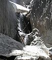 Little Falls on June 1, 2008
 -
 Entrance and Sign
 -
 A hiking trail in the mountains.
 -
 Forest Service sign at the Visitor center
 -
 Charleston Peak South Loop Trail Sign
 -
 Fall Colors on South Loop Trail to Charleston Peak


References[edit]
- ^ "Spring Mountains National Recreation Area Office". USDA Forest Service.
External links[edit]
| LV Transportation | |||||||
|---|---|---|---|---|---|---|---|
| Arts and museums |
| ||||||
| Sports | |||||||
| Government | |||||||
| Communities |
| ||||||
| Research and education | |||||||
| Parks and public spaces |
| ||||||
| Area shopping |
| ||||||
| Other | |||||||
| Authority control databases: National |
|---|
- IUCN Category V
- Spring Mountains
- Humboldt–Toiyabe National Forest
- Protected areas of Clark County, Nevada
- Protected areas of Nye County, Nevada
- National Recreation Areas of the United States
- Protected areas of Nevada
- Protected areas of the Great Basin
- Protected areas of the Mojave Desert
- Protected areas established in 1993
- 1993 establishments in Nevada