
Eastern Wengenkopf
| Eastern Wengenkopf | ||
|---|---|---|
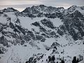
 East view from the western Wengenkopf ( 2235 m ) |
||
| height | 2207 m above sea level NHN | |
| location | Bavaria , Germany | |
| Mountains | Thumb group , Allgäu Alps | |
| Dominance | 0.8 km → West Wengenkopf | |
| Notch height | 63 m ↓ notch to the western Wengenkopf | |
| Coordinates | 47 ° 25 '33 " N , 10 ° 21' 38" E | |
|
||
| rock | Main dolomite | |
| particularities | Part of the Hindelanger via ferrata | |

The eastern Wengenkopf is 2207 m above sea level. NHN high mountain peak in the Allgäu Alps in the German state of Bavaria . The Hindelang via ferrata leads over the summit .
Location and surroundings
The summit, located in the subgroup thumb group , rises in the ridge that runs from the Nebelhorn ( 2224 m above sea level ) to the northeast to the Großer Thumb ( 2280 m ). The western mountain neighbor is the western Wengenkopf ( 2235 m ). Between the two peaks lies the saddle ( 2144 m ), which is the reference point for the saddle height of the eastern Wengenkopf. To the northeast, towards the Big Thumb, are the onion strands . The summit is in the district of Oberstdorf .
height
In the Alpine Club Guide Allgäu Alps from 1985, the official altitude of the eastern Wengenkopf of 2206.5 m is listed as incorrect. According to this, the east summit would be two meters higher than the west summit, i.e. 2238 m high.
Origin of name
A Wenger head B was first mentioned in 1774 by Peter Anichs Atlas Tyrolensis . It was named after the Wengen Alpe, whose pasture area lies south of the mountain. Wengen is the plural of the word "Wang", which means "natural pastureland".
geology
The appearance of the ridge where the Eastern Wengen head is located, is marked by a Hauptdolomit - thrust . This rises to the north and then shows folded folds to the north . This results in the more gentle south-facing slopes and the steep north-facing slopes. In the north there is a broad band of spotted marls, the valley floor at the northern foot of the mountain is formed by Kössen layers .
Alpinism
The Edmund-Probst-Haus ( 1927 m ) on the Nebelhorn and the Nebelhornbahn are the bases for ascent of the eastern Wengenkopf .
Normal way
Most of the summit as part of a celebration of Hindelanger ferrata exceeded . This is a moderately difficult via ferrata ( B / C ) on the Wengenkopf with partially unsecured climbing passages in the I degree . There are emergency descents from the via ferrata in the notches to the west and northeast of the summit.
Climb
There are several climbing routes on the eastern Wengenkopf. In addition to the north face (II) and the spiral crack on the west shoulder (IV +, A1) from 1944 by Tröndle and Amling, the La Traviata (VIII +) route in the south face, which Robert Jasper and Stefan Meineke first climbed in 1994, should be mentioned.
gallery

South side
North side

Nebelhorn ridge - big thumb


Web links
Individual evidence
- ↑ Map services of the Federal Agency for Nature Conservation ( information )
- ↑ Bavarian Surveying Administration : Page no longer available , search in web archives: BayernViewer 2.0 . Retrieved June 3, 2012.
- ↑ Ernst Zettler, Heinz Groth: Alpine Club Guide - Allgäu Alps . 12th, completely revised edition. Bergverlag Rudolf Rother, Munich 1985, p. 153.
- ^ Thaddäus Steiner : Allgäu mountain names . 2nd Edition. Kunstverlag Josef Fink, Lindenberg 2008, ISBN 978-3-89870-389-5 , p. 215.
- ^ Herbert Scholz: Building and Becoming the Allgäu Landscape . E. Schweizerbart'sche Verlagbuchhandlung (Nägele and Obermiller), Stuttgart 1995, pp. T5, T17.
- ↑ Dieter Seibert: Alpine Club Guide alpine - Allgäu Alps and Ammergau Alps . 17th edition. Bergverlag Rother, Munich 2008, ISBN 978-3-7633-1126-2 , p. 284.
- ↑ Dieter Seibert: Rother hiking guide - Allgäu Alps: high-altitude trails and via ferratas . 13th edition. Bergverlag Rother, Munich 2008, ISBN 978-3-7633-3120-8 , p. 54 f.
- ↑ Ernst Zettler, Heinz Groth: Alpine Club Guide - Allgäu Alps . 12th, completely revised edition. Bergverlag Rudolf Rother, Munich 1985, p. 435.
- ^ Stefan Meineke: Climbing in the Allgäu . In: Bergsteiger special 14: Allgäu . Bruckmann, Munich 2007, ISBN 978-3-7654-4647-4 , p. 66.