
19-Lachter-Stollen
| 19-Lachter-Stollen | |||
|---|---|---|---|
| General information about the mine | |||
 |
|||
| Information about the mining company | |||
| Start of operation | 1535 or 1551 | ||
| Funded raw materials | |||
| Degradation of | |||
| Geographical location | |||
| Coordinates | 51 ° 49'26.1 " N , 10 ° 16'53.1" E | ||
|
|||
| Location | Mountain town of Wildemann | ||
| local community | The mining town of Clausthal-Zellerfeld | ||
| District ( NUTS3 ) | Goslar | ||
| country | State of Lower Saxony | ||
| Country | Germany | ||


The 19-Lachter-Stollen (also called Oberer Wildemanns-Stollen , Getroster Hedwigstollen or Sechszig-Lachter-Stollen ) is a water solution gallery of the Upper Harz mining industry .
The mouth of the tunnel is located in Wildemann , a district of the mountain and university town of Clausthal-Zellerfeld . From here it extends over a length of 8.8 km to behind Clausthal-Zellerfeld. In its course, the tunnel was used for water retention , i.e. the drainage of the mine water , the ore mines of the Wildemanner, the Zellerfeld and later also the Clausthaler Revier connected to it.
The 19-Lachter-tunnel was as part of the 2010 Upper Harz Water Regale for World Heritage of UNESCO under the name Mines of Rammelsberg, Historic Town of Goslar and Upper Harz Water appointed.

history
Under Duke Heinrich the Younger , in 1535, the starting point for the first mouth hole was chosen on the Innerste opposite the Wildemann town hall. The actual work began in 1551 to create a way to ventilate the Tiefen Wildemanns tunnel . Due to the very hard rock, work was stopped in the same year. It was not until 1570 that Duke Julius continued work on what was then known as the Getroster Hedwigstollen tunnel. Until 1690 he was driven into the mountain with arduous work, initially with a mallet and iron . The advance per miner and shift was only between one and a few centimeters.
In this way, after 2308 Lachtern (4440 m), the Clausthaler Markscheide was reached in 1685 and after a further 2150 Lachtern (4136 m) the Prinzess-Elisabeth mine . In addition, the tunnel was extended by a further 126 puddles (242 m) to the final total length. At the end, at the Caroline pit in the Burgstätter corridor far behind Clausthal-Zellerfeld, the tunnel brings a depth of 115 meters.
At the original mouth hole, the sinking of the Haus Ditfurth pit began in 1690 .
Use as a water solution tunnel
Although initially designed as a ventilation tunnel , it was later connected to the 16 Lachter tunnel located higher up and converted into a water solution tunnel. The 13-Lachter-Stollen , also known as the Tiefer Wildemanns-Stollen , had already been started beforehand. Because of the extremely hard rock, the tunnels were driven at different speeds. The 16-Lachter tunnel first reached the Rheinischer Wein mine in Zellerfeld ; 19 and 13 Lachter tunnels followed only later, creating a system that allowed the Zellerfeld Zug to be drained and shafts to be sunk to a depth of approx. 200 m. After the 13-Lachter-tunnel was connected, the 19-Lachter-tunnel partly dried up again and could be driven on.
From 1809 the Adolfstollen (also 19-Lachter-Adolph-Stollen ) was driven from a new mouth hole. In 1819, this new tunnel was penetrated by the House of Sachsen Schacht of the Neuer St. Joachim mine and from 1840 it was used as the new mouth hole of the 19-Lachter tunnel. In this way, ores extracted from the Neuer St. Joachim mine were fed directly to the stamping works via the Ernst-August blind shaft.
Naming
The name 19-Lachter-Stollen comes from the " Lachter ", a length used in mining. The tunnel was so named because it was 19 Clausthaler Lachter (approx. 36 m) below the Glücksward tunnel , which in turn was also called the 16 Lachter tunnel , because it had 16 Lachter tunnel below the Frankenscharrn tunnel , the main tunnel of the eastern Zellerfeld corridor, lay.
Ernst-August mine
The greywacke into which the tunnel was driven also contains isolated veins . In particular, on the first stretch near Wildemann, ore was opened up and mined from the tunnel. For this purpose, among other things, the Ernst August blind shaft from the 19-Lachter-Adolph tunnel was sunk as a large test construction from 1844. Especially promising ore discoveries on the bottom of the 13-Lachter-adit led to this decision. A few years later, the shaft became important when the Ernst-August-Adit was being driven , although there were heavy water accesses. Shortly after 1860, the blind shaft was penetrated by a cross passage with the Ernst August tunnel at a depth of 112 Lachtern (215 meters).
The mine was named after the then sovereign Ernst August von Hannover . The Ernst-August mine was in operation until 1924, when it was shut down.
Show mine
From Wildemann, a 500 m long section of the 19-Lachter-Adolph tunnel up to the blind shaft can be viewed as a visitor mine . The tunnel gives a good impression of the narrowness underground and the laborious work of the miners. Sometimes it is only about 1.40 m high; Normal to tall visitors have to stoop over long distances.
After a few hundred meters of driving through the tunnel, a view from a steel bridge into the yawning depth of the originally 261 m deep blind shaft opens up. This has been equipped with a 250 W vapor pressure lamp since 1996 , which hangs 5 m below the steel bridge; Since 2015, an LED lamp has been illuminating the lower area of the shaft 100 m below . The tour also includes a visit to a wheel room with the sweeping wheel, reconstructed in 2013, with a diameter of 9 m and a width of 2 m. There is also a former Kunstradstube , which was modernized into a turbine and compressor room in 1914, as well as a machine room with an electric hoisting machine, which also dates from 1914.

Ernst-August blind shaft in the show mine

Gallery of the show mine
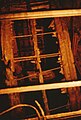
Sweeping wheel in the 19-Lachter-Stollen show mine (1995). In the meantime, the crumbling historical sweeper wheel has been removed and a new one has been installed.


literature
- Hans G. Dirks: The 19 Lachter tunnel and the Ernst August pit in Wildemann . Pieper, Clausthal-Zellerfeld 1989.
- U. Dumreicher: Entire overview of the water management of the north-western Upper Harz . Verlag der Grosse'schen Buchhandlung, Clausthal 1868.
- Friedrich Ludwig Christian Jugler : The Upper Harz silver mining at the end of the year 1849 and the Ernst August tunnel . In: CJB Karsten, H. v. Dechen (Ed.): Archives for mineralogy, geognosy, mining and metallurgy . tape 26 Issue 1. Georg Reimer, Berlin 1854, p. 199-294 .
See also
- List of mines in the Harz Mountains
- List of water solution tunnels in the Upper Harz
- Rammelsberg mine, old town of Goslar and Upper Harz water management
Web links
- UNESCO World Heritage in the Harz Mountains
- Official website of the mine
- Photos from the 19-laughing tunnel
- Journey to the center of the tunnel. The sweeping wheel in the 19-Lachter-Stollen visitor mine in Upper Harz is being restored , in: Monuments Online 1.2014
Individual evidence
- ↑ a b c d Wilfried Ließmann: Historical mining in the Harz . 2nd Edition. Springer, Berlin 1997, ISBN 3-540-62930-0 .
- ↑ a b c Dumreicher: Entire overview of the water management of the north-western Upper Harz. 1868, p. 32.
- ^ Ministry for Science and Culture of Lower Saxony: Upper Harz Water Management System. (PDF) 2008, p. 26 , accessed on December 2, 2015 (English).
- ↑ a b Dennert-Tanne 18.Retrieved on December 6, 2015 .
- ↑ a b Dennert-Tanne 123.Retrieved on July 18, 2014 .
- ↑ a b 19-Lachter-Stollen. Retrieved May 12, 2009 .
- ↑ Dennert-Tanne 50.Retrieved on July 18, 2014 .
- ↑ The 19-Lachter-Stollen. Retrieved May 12, 2009 .
- ↑ Jugler: The Upper Harz silver mining at the end of 1849 and the Ernst August tunnel. In: Archives for Mineralogy, Geognosy, Mining and Metallurgy. , Volume 26, Issue 1, 1854, p. 238.
- ↑ The new sweeper bike. Retrieved February 28, 2016 .