Alberta Highway 58
| Highway 58 in Alberta, Canada | |||||||||||||||||||||||||||||||

|
|||||||||||||||||||||||||||||||
| map | |||||||||||||||||||||||||||||||
| Basic data | |||||||||||||||||||||||||||||||
| Operator: | Alberta Transportation | ||||||||||||||||||||||||||||||
| Start of the street: |
Rainbow Lake ( 58 ° 29 ′ N , 119 ° 26 ′ W ) |
||||||||||||||||||||||||||||||
| End of street: |
Wood Buffalo National Park ( 58 ° 35 ′ N , 114 ° 40 ′ W ) |
||||||||||||||||||||||||||||||
| Overall length: | 325 km | ||||||||||||||||||||||||||||||
|
Course of the road
|
|||||||||||||||||||||||||||||||
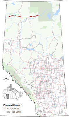
The Alberta Highway 58 is located in the north of the Canadian province of Alberta , he has km in length 325th The route is listed in the National Highway System between the western end and Highway 88 as the Northern Route.
course
The highway begins at Rainbow Lake Airport in the west of the small town of Rainbow Lake . From there it leads east, crosses the Chinchaga River and reaches High Level . There the route meets Highway 35 , an approximately 1.5 km long section leads together through the city. Highway 58 continues east, north of Fort Vermilion , Highway 88 branches off to the south. The highway then ends at the edge of Wood Buffalo National Park , within the park it continues as Garden Road to Garden River . The entire highway is thus within Mackenzie County .
Individual evidence
- ^ Alberta Highways 1 to 986 - Traffic volume, vehicle classification, travel and esal statistics report 2015. Transportation Alberta, accessed on December 21, 2016 (English).
- ↑ Canada's National Highway System, Annual Report 2015. (PDF, 5.28 MB) Council of Ministers Responsible for Transportation and Highway Safety, September 2016, accessed on December 21, 2016 .
