Alberta Highway 5
| Highway 5 in Alberta, Canada | |||||||||||||||||||||||||||||||||||||||||||||||||||||||

|
|||||||||||||||||||||||||||||||||||||||||||||||||||||||
| map | |||||||||||||||||||||||||||||||||||||||||||||||||||||||
| Basic data | |||||||||||||||||||||||||||||||||||||||||||||||||||||||
| Operator: | Alberta Transportation | ||||||||||||||||||||||||||||||||||||||||||||||||||||||
| Start of the street: |
Waterton Park ( 49 ° 3 ′ N , 113 ° 55 ′ W ) |
||||||||||||||||||||||||||||||||||||||||||||||||||||||
| End of street: |
Lethbridge ( 49 ° 42 ′ N , 112 ° 49 ′ W ) |
||||||||||||||||||||||||||||||||||||||||||||||||||||||
| Overall length: | 110 km | ||||||||||||||||||||||||||||||||||||||||||||||||||||||
|
|||||||||||||||||||||||||||||||||||||||||||||||||||||||
|
Course of the road
|
|||||||||||||||||||||||||||||||||||||||||||||||||||||||
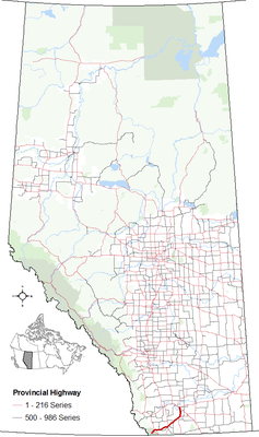
The Highway 5 (short AB 5 ) is a highway in the Canadian province of Alberta . It begins in Waterton Lakes National Park and ends on Highway 3 , the Crowsnest Highway , in Lethbridge . The entire route is 110 km long and is not part of the Canadian National Highway System .
Routing
The highway begins in Waterton Lakes National Park in Waterton Lake . There is a fee to stay in the park, there is an entrance fee for national parks. The route heads northeast and meets Highway 6 , which comes in from the south of the United States and heads north to Chief Mountain . The highway continues northeast to the national park border, from there to the east towards Mountain View .
From there, the highway runs northeast again, passing the towns of Cardston and Magrath . The Highway 2 crosses in Cardston, a short distance run Highways 2 and 5 on the same street. In Magrath, Highway 62 branches off to the south; On the further course of the Highway 5 to Lethbridge, Highway 52 begins, which is a shortcut to Highway 4 . The further route leads north to the town of Lethbridge.
Individual evidence
- ^ Alberta Highways 1 to 986, traffic volume, vehicle classification, travel and esal statistic reports. (pdf, 581 KB) Government of Alberta - Ministry of Transportation, 2012, p. 10 , accessed on April 8, 2013 .
- ^ List of Fees. Parks Canada , accessed March 29, 2018 .
- ↑ Provincial Highways 1 - progress chart 216th (pdf, 7.92 MB) Government of Alberta - Ministry of Transportation, 2010, accessed on April 8, 2013 .
