Alberta Highway 35
| Highway 35 in Alberta, Canada | ||||||||||||||||||||||||||||||||||||||||||||||||||||||||||||||||||||||||||||
| Mackenzie Highway | ||||||||||||||||||||||||||||||||||||||||||||||||||||||||||||||||||||||||||||

|
||||||||||||||||||||||||||||||||||||||||||||||||||||||||||||||||||||||||||||
| map | ||||||||||||||||||||||||||||||||||||||||||||||||||||||||||||||||||||||||||||
| Basic data | ||||||||||||||||||||||||||||||||||||||||||||||||||||||||||||||||||||||||||||
| Operator: | Alberta Transportation | |||||||||||||||||||||||||||||||||||||||||||||||||||||||||||||||||||||||||||
| Start of the street: |
Grimshaw ( 56 ° 14 ′ N , 117 ° 37 ′ W ) |
|||||||||||||||||||||||||||||||||||||||||||||||||||||||||||||||||||||||||||
| End of street: |
Indian Cabins ( 60 ° 0 ′ N , 116 ° 59 ′ W ) |
|||||||||||||||||||||||||||||||||||||||||||||||||||||||||||||||||||||||||||
| Overall length: | 465 km | |||||||||||||||||||||||||||||||||||||||||||||||||||||||||||||||||||||||||||
|
Course of the road
|
||||||||||||||||||||||||||||||||||||||||||||||||||||||||||||||||||||||||||||
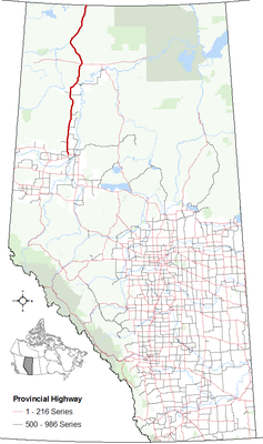
The Alberta Highway 35 is located in the northwest of the province, he also has the nickname Mackenzie Highway. The entire length of the highway is part of the National Highway System of Canada and is used here as a core route. Its length is 465 km.
Route
The Mackenzie Highway begins as the junction of Highway 2 north of Grimshaw . It leads largely in a northerly direction and opens up the north-west of the province of Alberta , a landscape that is predominantly characterized by forests. The highway runs through two larger towns, Manning and High Level . This is also where Highway 58 crosses , which leads to Wood Buffalo National Park . The highway ends at the border with the Northwest Territories and continues from there to Yellowknife .
Web links
- 2015 Provincial Highways 1 - 216 Series Progress Chart. (PDF, 9 MB) Alberta Transportation, accessed on July 25, 2016 .
Individual evidence
- ↑ Canada's National Highway System, Annual Report 2014. (PDF, 1.45 MB) Council of Ministers Responsible for Transportation and Highway Safety, September 2015, accessed on July 25, 2016 .
- ^ Alberta Highways 1 to 986 - Traffic volume, vehicle classification, travel and esal statistics report 2015. Transportation Alberta, accessed on July 25, 2016 (English).
