
Albertirsa
| Albertirsa | |||||
|
|||||
| Basic data | |||||
|---|---|---|---|---|---|
| State : | Hungary | ||||
| Region : | Central Hungary | ||||
| County : | pest | ||||
| Small area until December 31, 2012 : | Cegléd | ||||
| District since 1.1.2013 : | Cegléd | ||||
| Coordinates : | 47 ° 15 ′ N , 19 ° 36 ′ E | ||||
| Area : | 72.96 km² | ||||
| Residents : | 12,394 (Jan. 1, 2011) | ||||
| Population density : | 170 inhabitants per km² | ||||
| Telephone code : | (+36) 53 | ||||
| Postal code : | 2730 | ||||
| KSH kódja: | 31653 | ||||
| Structure and administration (status: 2018) | |||||
| Community type : | city | ||||
| Mayor : | László Fazekas (TEAM Választási Szövetség) | ||||
| Postal address : | Irsay Károly u. 2 2730 Albertirsa |
||||
| Website : | |||||
| (Source: A Magyar Köztársaság helységnévkönyve 2011. január 1st at Központi statisztikai hivatal ) | |||||


Albertirsa is a Hungarian town in the district Cegléd in Pest County .
Geographical location
Albertirsa is located 50 kilometers southeast of the center of the capital Budapest. Neighboring communities are Ceglédbercel , Pilis and Dánszentmiklós .
history
Albertirsa was created in 1950 through the merger of the formerly independent towns Alberti and Irsa ( German Irschau , Slovak Irša ).
Attractions
- Evangelical Church, built 1774–1778 (Baroque)
- Roman Catholic Church Urunk színeváltozása , built 1744–1746, expanded in 1856

View of the Roman Catholic. Urunk Színeváltozása Church (1910)
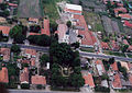
Aerial view of the city, 2006. The Evangelical Church can be seen in the center of the picture.


Infrastructure
The only substation for 750 kV in Hungary, see 750 kV line Albertirsa – Sachidnoukrainskaja – Vinnyzja .
Town twinning
-
 Bourg-Saint-Andéol , France
 -
 Gaggiano , Italy
 -
 Malacky , Slovakia
 -
 Șimleu Silvaniei , Romania
 -
 Żnin , Poland
sons and daughters of the town
- Rosa Csillag (1832–1892), Austro-Hungarian opera singer
- Adam Politzer (1835–1920), Austro-Hungarian physician
traffic
The main road No. 40 runs through Albertirsa, where the country roads No. 3115 and No. 4607 meet. The city is connected to the railway line from Budapest Westbahnhof to Cegléd .
Web links
- Alberti in A Pallas nagy lexikona ( Hungarian )
- Irsa in A Pallas nagy lexikona (Hungarian)