
Old town Merkendorf
|
Old town
City of Merkendorf
Coordinates: 49 ° 12 ′ 14 ″ N , 10 ° 42 ′ 6 ″ E
|
|
|---|---|
| Height : | 438 m above sea level NN |
| Postal code : | 91732 |
| Area code : | 09826 |
 |
|
The old town of Merkendorf in the Franconian Lake District ( Middle Franconia ) dates from the late Middle Ages and has an almost square floor plan.
Old town
construction
The ensemble includes the walled medieval town late that as a proper city of its decisive shaping the 15th century monastery Heilsbronn and administrative seat of the provost received Altmühl. The city fortification with three gates and eight smaller round and rectangular towers surrounds an almost rectangular area, which is criss-crossed by an irregular network of alleys that is less due to planned urban architecture of the 15th century than to routes from earlier centuries and clearly an older town center around the City church between the upper gate and town hall can be recognized. The Heilsbronn Monastery had systematically bought up all the goods of various lords there since the 13th century.
Course of the road network
The for Taschentor leading Adler road meets the market square in the center of the Upper to the Lower Gate pulling main street . The most important buildings, such as the late-Gothic town hall, the former administrative building , the former tithe barn and the Zur Sonne inn, are located on the market square, effectively arranged in an urban-planning manner .
Facade design
The main and side streets of the city center have an almost closed, gable and eaves-sided development with mostly plastered timber-frame parts, which were mostly renewed in the 17th and 18th centuries after heavy destruction in the Thirty Years' War . Most of the buildings are evidence of arable bourgeois prosperity, which arose from the cultivation of herbs that began after the Thirty Years' War , the time after the secularization of the monastery state, in which Merkendorf was subordinate to a margrave of Ansbach city bailiff . In addition to the houses, the often stately barns assigned to them determine the street scene.
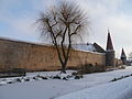
Water-filled ditch at the city fortifications


environment
In the vicinity of the city wall there are partly single-storey craftsmen's houses and small farms, often with a late medieval core, partly larger farms and extensive gardens.
Today's appearance
War losses in the Second World War and the altered reconstruction of individual properties led to disruption of the site's appearance.
Streets
The following streets are within the wall ring:
- (Inner) main street (runs from north to south through the old town)
- Market square (the fair was held there in the Middle Ages )
- Schulstrasse (west of the main street; named after the former technical school )
- Brauhausstraße (east of the main street; named after the former Hellein brewery , which had its brewery on this street).
- Weberstrasse (east of the main road; named after the weavers who once had a large guild in Merkendorf)
- Eagle Road (east of the main road, in the era of National Socialism in Ritter-von-Epp-road renamed)
- Gerberstrasse (east of the main street; named after the tanners )
The ring road runs around the city wall, part of the state road St 2220, which leads from Windsbach to Weidenbach .
Suburb
The suburb to the south, probably built in the 17th century, is largely built up. Otherwise, however, the encirclement of the city fortifications over long stretches in the west, southwest and southeast shows in a very original way the transition from the city fortifications, which are partially filled with water, to the flat surrounding area.
Streets
- (Outer) main street (runs from Untere Tor to B 13 )
- Bahnhofweg (west of the main street; leads to Triesdorf train station )
- Hirschlacher Straße (continuation of the main road after the B 13; leads in the direction of Hirschlach )
- Espanstraße (branches off from Hirschlacher Straße; named after Espan )
- Feldstrasse (branches off from Hirschlacher Strasse)
- At the sports field (around the TSV hall)
- Heglauer Straße (leads to Heglau )
The suburb is divided by the B 13. The federal road is called Gunzenhausener Straße through Merkendorf, as it leads south to Gunzenhausen .
See also
Web links
- Old town Merkendorf in the Bavarian Monument Atlas
- City guide through the old town