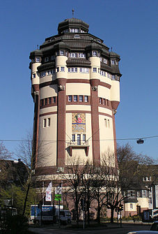
At the water tower (Mönchengladbach)
|
At the water tower
City of Mönchengladbach
|
|
|---|---|
| Coordinates: 51 ° 12 ′ 3 ″ N , 6 ° 25 ′ 34 ″ E | |
| Area : | 99.7 ha |
| Residents : | 4933 (December 31, 2018) |
| Population density : | 4,948 inhabitants / km² |
| Postcodes : | 41061, 41063, 41068 |
| Area code : | 02161 |
|
Location of Am Wasserturm in the northern district of Mönchengladbach
|
|
|
The water tower at the intersection of Lindenstrasse and Viersener Strasse gives the district its name
|
|
At the water tower is a district of Mönchengladbach . It belongs to the northern district and had 4933 inhabitants as of December 31, 2018.
Culture and sights
The water tower on Viersener Strasse is the eponymous building of this district.
media
There are local advertising papers such as Extra-Tipp on Sunday and StadtSpiegel on Wednesday. The CityVision broadcaster , which reports on Mönchengladbach and the surrounding region, is available for customers of Unitymedia on analogue cable TV and via DVB-C. Just like the radio station Radio 90.1 Mönchengladbach, which can also be received terrestrially or via live stream on the Internet, the local radio for the city of Mönchengladbach.
Individual evidence
- ↑ https://www.moenchengladbach.de/fileadmin/user_upload/statistik/Bevölker_nach_Stadtbezirken_und_Stadtteile__12_2018.pdf


