Bungt
|
Bungt
City of Mönchengladbach
Coordinates: 51 ° 11 ′ 34 " N , 6 ° 27 ′ 20" E
|
|
|---|---|
| Area : | 1.43 km² |
| Residents : | 228 (December 31, 2018) |
| Population density : | 159 inhabitants / km² |
| Postal code : | 41065 |
| Area code : | 02161 |
|
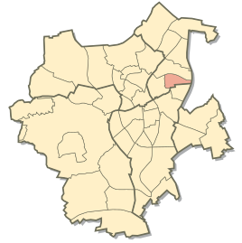
Location of Bungt in the east district of Mönchengladbach
|
|
Bungt is a district of Mönchengladbach that has been in the eastern district since the restructuring in 2009 . Before that it belonged to the Volksgarten district .
Location and population
The district of Bungt extends between the districts of Lürrip in the north, Hardterbroich-Pesch in the west, Rheydt Castle in the south and the city limits of Mönchengladbach to Korschenbroich in the east. It consists mainly of forest areas and the Volksgarten , a large park with a playground by a pond and the Volksbad outdoor pool . There is also an allotment gardening association in the north-west of the district and a shooting range in the east. A few houses are only in the south.
The number of buildings and therefore the population is correspondingly low:
| year | population |
| 2013 | 200 |
| 2014 | 197 |
| 2015 | 462 |
| 2016 | 324 |
| 2017 | 221 |
Nevertheless, in 2017 there were two districts with an even smaller population: Hardter Wald and Rheydt Castle.
Infrastructure
The national road 381 (Korschenbroicher road) runs along the northern boundary of the district, it is traveled by bus number 031, which has two stops at the edge of the district. The 008 bus runs through the district with stops u. a. at the Volksbad and at the Volksgarten.
About 200 meters north of the northern border on the Mönchengladbach – Düsseldorf railway line is the Mönchengladbach- Lürrip S-Bahn stop , which is served by the S 8 line of the Rhein-Ruhr S-Bahn .
Web links
Individual evidence
- ↑ https://www.moenchengladbach.de/fileadmin/user_upload/statistik/Bevölker_nach_Stadtbezirken_und_Stadtteile__12_2018.pdf
- ↑ Statistical Handbook Mönchengladbach 2013-2017. March 2019, p. 21 , accessed on September 12, 2019 .

