
Asad Jammu and Kashmir
| flag | |||
|
|||
| Basic data | |||
|---|---|---|---|
| Capital : | Muzaffarabad | ||
| Status: | semi-autonomous area | ||
| Area : | 11,639 km² | ||
| Residents : | approx. 4,045,366 (2017) | ||
| Population density : | approx. 300 inhabitants / km² (2017) | ||
| ISO 3166-2 : | PK-JK | ||
| map | |||
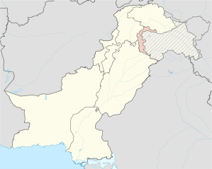 _(claims_hatched).svg) |
|||


Asad Jammu and Kashmir (short Asad Kashmir ; Urdu : آزاد جموں و کشمیر Azad Jammu o Kashmir , English: Azad Jammu and Kashmir , short Azad Kashmir or AJK ) is a semi-autonomous Pakistani area in the disputed between India , Pakistan and the People's Republic of China Kashmir region .
politics
The official name Azad Jammu and Kashmir (= Free Jammu and Kashmir) on the Pakistani side underscores Kashmir's claim to self-determination and the "free" Jammu and Kashmir the "unfree" part on the Indian side ( Jammu and Kashmir and Ladakh ) juxtaposed.
As a result, Asad Kashmir is not a province of Pakistan , but elects its own parliament, its own prime minister and its own president (otherwise: governor ). On the other hand, Pakistan's leadership clearly sees the future of Kashmir as part of the Islamic Republic of Pakistan and not as an independent country. Political parties seeking independence for Kashmir will not be allowed to vote. PML-N currently rules with Prime Minister Farooq Haider Khan. Apart from its formal autonomy, Asad Kashmir is economically and militarily a fully integrated part of Pakistan. Not part of Asad Kashmir is Gilgit-Baltistan (referred to as Northern Territories until 2009), which was claimed by the Maharajah Kashmir until 1947 ; a claim that has been denied by Pakistan since then and which was not secured militarily.
geography
Asad Kashmir borders the Punjab Province (south), the Khyber Pakhtunkhwa Province (west), Gilgit-Baltistan and the Indian Union Territory of Jammu and Kashmir . It is a narrow strip of 11,639 km² to the west of the Indian Jammu and Kashmir, separated from them by the armistice line that has been in force since 1965. In the northern part of Asad Kashmir (Muzaffarabad division), which is shaped by the western foothills of the Himalayas , the valley of the Nilam (English: Neelum or Neelam) dominates. Not far from the capital Muzaffarabad (approx. 300,000 inhabitants) he leaves Asad Kashmir to the west. The southern part is less mountainous and more densely populated.
The most important river valleys are those of the Jhelam (English: Jhelum) and Punch (English: Poonch), which feed the large Mangla reservoir on the border with the Punjab province. This was completed in 1967 after five years of construction and today (after five stages of expansion) it generates up to 1150 megawatts in peak load times, a good 20% of Pakistan's hydropower (as of 2001).
The hydropower plant is Asad Kashmir's most important industrial center by far. The rest of the country is dominated by agriculture and developed only below average. The main crops are cereals and tree fruits, for example apples, apricots, pears, plums and walnuts.
Earthquake region
On October 8, 2005, Asad Kashmir, which lies on the border between the Indian-Australian plate and the Eurasian plate , was hit by a violent earthquake measuring 7.6 on the Richter scale . The epicenter of the quake was near Muzaffarabad and was close to the surface of the earth. The simple construction of most of the buildings caused considerable property damage, with around 200,000 dead in the region.
population
According to the 2002 update, Asad Kashmir has 3.2 million inhabitants, which is more than half more than in 1981. Population growth is over 2.5%, and each household has an average of seven members. According to official information, the population is 99% Muslim. Population groups are the Hindko , Potwari and the nomadic Gudjar. The languages of the first two ethnic groups are related to Punjabi . Numerous Kashmiri people immigrated to Britain in the 1950s and 1960s and form part of the British Pakistani ethnic minority .
Administrative division
Asad Kashmir is divided into 3 divisions , which in turn are divided into a total of 10 districts.
| division | District | Area in km² |
Pop. (2008) |
Administrative seat |
|
|---|---|---|---|---|---|
| Mirpur | Mirpur | ||||
| Bhimber | 1516 | 301,633 | Bhimber | ||
| Kotli | 2162 | 834.094 | Kotli | ||
| Mirpur | 2310 | 754.482 | Mirpur | ||
| Muzaffarabad | Muzaffarabad | ||||
| Hattian | 854 | 251,000 | Hattian Bala | ||
| Muzaffarabad | 2496 | 638.973 | Muzaffarabad | ||
| Nilam | 3621 | 106,778 | Athmuqam | ||
| Punch | Rawalakot | ||||
| Bagh | 768 | 351.415 | Bagh | ||
| Haveli | 600 | 150,000 | Forward Kahuta | ||
| Punch | 855 | 411.035 | Rawala feces | ||
| Sudhanoti | 569 | 204.091 | Palandri | ||
| all in all | 13,297 | 4,567,982 | Muzaffarabad | ||
The data on the Haveli district are estimated.
literature
- Cabeiri deBergh Robinson: Body of Victim, Body of Warrior: Refugee Families and the Making of Kashmiri Jihadists. University of California Press, 2013, ISBN 978-0-520-27420-4 . ( Table of Contents ) ( Google extract )
Web links
Provinces: Balochistan | Khyber Pakhtunkhwa | Punjab | Are
Territories: Islamabad Capital Territory | Asad Kashmir | Gilgit-Baltistan
Coordinates: 34 ° 6 ' N , 73 ° 42' E