
Aubach (near Schwerin)
| Aubach | ||
 Aubachtal between Kirch Stück and Schwerin |
||
| Data | ||
| Water code | DE : 59282 | |
| location | Germany , Mecklenburg-Western Pomerania , West Mecklenburg | |
| River system | Elbe | |
| Drain over | Pfaffenteich → Ziegelsee → Schweriner See → Stör → Stör Canal → Elde → Elbe → North Sea | |
| source |
Kleiner Dambecker See 53 ° 46 ′ 40 ″ N , 11 ° 23 ′ 11 ″ E |
|
| Source height | 52.4 m above sea level NHN | |
| muzzle |
Pfaffenteich in Schwerin Coordinates: 53 ° 47 '17 " N , 11 ° 23' 22" E 53 ° 47 '17 " N , 11 ° 23' 22" E |
|
| Mouth height | 39.2 m above sea level NHN | |
| Height difference | 13.2 m | |
| Bottom slope | 0.55 ‰ | |
| length | 24 km | |
| Catchment area | 120 km² | |
| Medium-sized cities | Schwerin | |
| Communities | Alt Meteln , Klein Trebbow | |

The Aubach (in the upper reaches also Seegraben ) is a brook in the northwest of Mecklenburg-Western Pomerania and rises from the Kleiner Dambecker See in the Dambecker Seen nature reserve about 12 kilometers south of Wismar. Inland drainage began in this area around 1870. The two Dambeck lakes were connected by a ditch and the water was fed through a connection into the Aubach. On its further way south the brook flows through the Trebbower See , the Barner Stücker See and after passing the Aubach valley with the partly adjacent wet meadows, into which the Aubach pours when the water levels are high, the Medeweg lake . Without any obstacles, the Aubach can only be traveled by paddle boats from the Barner Stücker See. The instructions on how to behave in protected landscape areas on and around Lake Medeweg are to be followed during the stream journey. In the inner city of Schwerin the Aubach flows into the artificially dammed Pfaffenteich . This flows over the Ziegel- and Heidensee into the Schweriner See .
- The Aubach belongs in the area of the Medeweger See to the landscape protection area Schweriner Innensee, Ziegelaußensee and Medeweger See . It is forbidden to enter the Medeweg lake with boats and other watercraft, with the exception of canoeists in the passage.
The total length of the Aubach is 24 kilometers, the catchment area 120 km². Above Lake Medeweg, the water body usually has high nutrient concentrations and low oxygen saturation values, primarily due to inputs from agriculture. Better quality values are regularly only found below Lake Medeweg, as the lakes through which it flows absorb the nutrients.
In front of the confluence with the Pfaffenteich there was the Bischofsmühle , which operated until 1914 , the remains of which were demolished in the 1930s and of which only remains of the foundations can be seen today. There was an inn of the same name on the Aubach site in 1971. Also in front of the confluence, near the Bürgermeister-Bade-Platz, you can see Schwerin's oldest preserved and now functionless bridge structure from 1773. It is in need of renovation. The Aubach, which was dammed up as a Pfaffenteich (formerly: Mühlenteich), also served to operate the count's mill on the south bank. The stream in the north of Schwerin is suitable for a sporty ride. The water sports enthusiasts have to drive under some low bridges, but new views of the northern part of Schwerin are to be discovered.
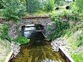
Aubach Bridge from 1773
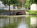
Mouth of the Aubach into the Pfaffenteich


| Technical buildings | Street | Comment on the stream and the surrounding area | Bridge images | Bach pictures |
|---|---|---|---|---|
| Road bridge | Barner Stücker Str. | Brook width approx. 3 m, crossing the Barnerstücker See, entry and exit through reeds | ||
| Landway bridge | old dirt road to Barner piece | Timber construction, on the bridge is a river level house | ||
| Road bridge | B 104 | three-lane concrete bridge, valley with wet meadows and mountainous pasture landscape | ||
| Road bridge | Medeweger Street | Low clearance for canoeists, passage to the 2.1 km long Medeweg lake, on it floats a "submarine", a water treatment system. The former Gosewinkler waterworks is located on the west bank (see Medeweger See ) | ||
| Railway bridge | Schwerin - Bad Kleinen route | Allotment gardens on the banks, brick bridge, journey between the former freight yard and Lewenberg | ||
| Road bridge | B104 Obotrite Ring | four-lane concrete bridge with two tram tracks | ||
| Bischofsmühlenbrücke | historic brick bridge | Bridge from 1773, fast flow of the brook, stones in the brook bed | ||
| Road bridge | Wismarsche Strasse | four-lane concrete bridge | ||
| Road bridge | Alexandinenstrasse | Bridge built in 1888, passage to the Pfaffenteich, then on the left a ramp for launching canoes |


Individual evidence
- ↑ Layer water network. Map portal Umwelt MV, accessed on February 2, 2014 .
- ^ City administration Schwerin: Landscape protection area Schweriner Innensee, Ziegelaußensee and Medeweger See. Retrieved August 24, 2020 .
- ↑ Landscape plan of the state capital Schwerin 2006. (PDF 2.9 MB) Retrieved on February 2, 2014 .
- ↑ Article “Oldest Bridge in Danger” - Schweriner Volkszeitung, April 4, 2008