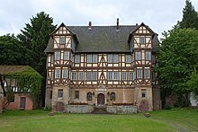
Aue (Wanfried)
|
Aue
City of Wanfried
Coordinates: 51 ° 10 '43 " N , 10 ° 7' 36" E
|
|
|---|---|
| Height : | 166 (163–225) m above sea level NHN |
| Area : | 7.14 km² |
| Residents : | 527 (Dec. 31, 2013) |
| Population density : | 74 inhabitants / km² |
| Incorporation : | December 31, 1971 |
| Postal code : | 37281 |
| Area code : | 05651 |
Aue ( ) is a district of Wanfried in the Werra-Meißner district in Hesse .
location
Aue lies between Eschwege and Wanfried south of the Werra on the slope of the Schlierbachswald . State road 3244 runs through the village .
history
The place is first mentioned in 1128 with the name Owa . Possibly the village already existed around 900. The early history of Aues is closely linked to the Aue moated castle on the northern outskirts , where the noble families von der Aue , von Hornsberg and von Eschwege were resident, and the Cyriakus pen in Eschwege . The village was long disputed between the Landgraviates of Hesse and Thuringia before it finally fell to Hesse in 1436.
On December 31, 1971, Aue was incorporated into the city of Wanfried.
Attractions
- Ruins of the moated castle Aue from the 12th century
- Manor house of the Aue manor, built in 1576
- 12th century church
- Half-timbered houses
Public facilities
In Aue there is a village community center , a gym and a sports field .
Personalities
- Wilhelm Ludwig von Eschwege (born November 15, 1777 in Aue, † February 1, 1855 in Wolfsanger ), miner, geologist and geographer
- Gottfried Kümmell (born March 25, 1866 in Aue, † July 17, 1922 in Rostock), professor of physical chemistry
Individual evidence
- ^ "Aue, Werra-Meißner district". Historical local dictionary for Hessen. (As of January 25, 2016). In: Landesgeschichtliches Informationssystem Hessen (LAGIS).
- ↑ Geodata Center: Aue , accessed in February 2016.
- ^ Federal Statistical Office (ed.): Historical municipality directory for the Federal Republic of Germany. Name, border and key number changes in municipalities, counties and administrative districts from May 27, 1970 to December 31, 1982 . W. Kohlhammer GmbH, Stuttgart and Mainz 1983, ISBN 3-17-003263-1 , p. 388 .
Web links
- Aue on the city of Wanfried's website
- "Aue, Werra-Meißner district". Historical local dictionary for Hessen. In: Landesgeschichtliches Informationssystem Hessen (LAGIS).
- Literature on Aue in the Hessian Bibliography


