Auerberg (Auerbach)
| Auerberg
Urberg, Schlossberg
|
||
|---|---|---|
|
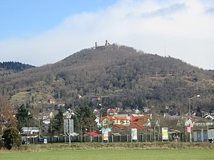
Auerberg seen from Auerbach. |
||
| height | 345.9 m above sea level NHN | |
| location | near Auerbach ; Bergstrasse District , South Hesse ( Germany ) | |
| Mountains | Odenwald | |
| Dominance | 0.82 km → Melibokus | |
| Coordinates | 49 ° 42 '31 " N , 8 ° 37' 56" E | |
| Topo map | LAGIS Hessen | |
|
|
||
| particularities | Auerbach Castle | |
The Auerberg (formerly also Kleiner Mal (s) chen or Großer Mal (s) chen and currently also called Urberg or Schlossberg ) near Auerbach in the Bergstrasse district in southern Hesse is 345.9 m above sea level. NHN high elevation in the Odenwald . On it stands the ruins of Auerbach Castle and on its slopes there are vineyards of the large area "Auerbacher Rott" of the Hessische Bergstrasse wine-growing region .
Mountain names
Other names of the Auerberg were Kleiner Mal (s) chen , named after an alternative name of its "big brother", the Melibokus or also Großer Mal (s) chen . The Auerberg is also called Schlossberg by the population .
geography
location
The Auerberg is located on the western edge of the Odenwald, east of the Upper Rhine Plain , in the Bergstrasse-Odenwald Nature Park . Directly east of Auerbach, a northern district of Bensheim , and west of Hochstädten , a north-northeastern district of Bensheim, it forms a south-southwest branch of the Melibokus ( 517.4 m ) on Bergstrasse . The Auer ( Mühlbach , Ziegelbach ) flows south past the elevation as the eastern tributary of the Winkelbach .
Natural allocation
The Auerberg belongs to the natural spatial main unit group Odenwald, Spessart and Südrhön (No. 14), in the main unit Vorderer Odenwald (145.0) and in the subunit Melibokus-Odenwald (145.0) to the natural area Melibokusmassiv (145.00). To the west, its landscape falls into the main unit group Northern Upper Rhine Lowland (22) and in the main unit Bergstrasse (226) into the subunit Mittlere Bergstrasse (226.4).
Fauna-flora habitat area
Part of the fauna-flora-habitat area Kniebrecht, Melibokus and Orbishöhe near Seeheim-Jugenheim, Alsbach and Zwingenberg (FFH no. 6217-305; 9.53 km² ) is located on the Auerberg .
Auerbach Castle
On the Auerberg the ruins of the stands from the west from the Upper Rhine Valley visible from the castle Auerbach ( Auerbach Castle ). From the two accessible towers you have a view over the Upper Rhine Plain, the front Odenwald and numerous villages at the foot of the mountains. On a clear day you can see the German Wine Route , the Donnersberg and the Palatinate Forest . The south tower, which was not accessible for over 50 years, has been given a new staircase and now offers visitors a view again.
Traffic and walking
To the north and east past the Auerberg runs - between the federal highway 3 in the west and the state road 3103 in the south - a steeply rising, narrow and winding one-way street that begins in the north of Auerbach as the Ernst-Ludwig-Promenade and leads to the east of the crest at the highest Place of the paved road at about 308 m above sea level at the Auerbacher Schloss car park and then down into the Auer valley between Hochstädten and Auerbach . At its ridge, a road that is closed to motor vehicles branches off in the direction of Auerbach Castle. You can hike on numerous hiking trails on and around the Auerberg created by the Odenwaldclub. The well-known “Blossom Path” and the popular “Weinlagewanderweg” are two of them.
literature
- Karl Wilfried Hamel: Auerbach Castle - Urberg Fortress - the most important castle complex in the Upper County of Katzenelnbogen . AAA-Verlag, Bensheim-Auerbach 1997, ISBN 3-9803139-0-5 .


