Berlin Storkower Strasse train station
| Berlin Storkower Strasse | |
|---|---|
|
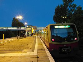
View over the platform to the east
|
|
| Data | |
| Operating point type | Breakpoint |
| Platform tracks | 2 |
| abbreviation | BSTO |
| IBNR | 8089041 |
| Price range | 4th |
| opening | May 4, 1881 |
| Website URL | s-bahn-berlin.de |
| Profile on Bahnhof.de | Storkower Strasse |
| location | |
| City / municipality | Berlin |
| Place / district | Prenzlauer Berg |
| country | Berlin |
| Country | Germany |
| Coordinates | 52 ° 31 '26 " N , 13 ° 27' 52" E |
| Railway lines | |
|
|
| Railway stations in Berlin | |
The Berlin Storkower Straße station is a station on the Ringbahn in the Berlin district of Prenzlauer Berg . It is served by the S41, S42, S8 and S85 S-Bahn lines . The station was opened under the name Zentralviehhof (initial spelling Central-Viehhof ). It is equipped with elevators and is therefore considered barrier-free .
history
The station opened on May 4, 1881. Before that, the Ringbahn had been expanded to four tracks from 1876 at the site of the newly created central cattle and slaughterhouse . With the first renovation in 1903, an underpass and side platforms were created, which were replaced by a central platform in 1929 . As the only ring station, it still has no roofing. The S-Bahn has been running here since February 1, 1929.
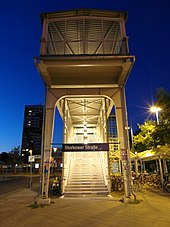
The central platform was originally connected to the slaughterhouse area to the south by a tunnel. In 1937 work began on building the longest pedestrian bridge in Berlin, which was to connect the residential area on Eldenaer Strasse in Friedrichshain with the S-Bahn. The bridge was completed in 1939 and was initially 420 meters long, it was popularly nicknamed " Long Jammer ". The footpath ran seven meters above the slaughterhouse site. The personnel tunnel was only used for official purposes for the employees of the slaughterhouse.
After the Second World War , the station was reopened in August 1945, but only for the Soviet occupying forces , who had set up a war bag store on the grounds of the slaughterhouse. In November 1947 the station was closed and the trains ran through without stopping. Only after the pedestrian bridge had been restored could it be put back into operation on July 25, 1951.
In the years 1976/1977 the footbridge was extended to the north to a new development area Storkower Straße and was then 505 meters long. Since October 15, 1977, the S-Bahn station has also been named Storkower Straße . A curiosity was that the train station was in the Prenzlauer Berg district, but the two exits across the bridge were in the Friedrichshain and Lichtenberg districts. In 1986 the tunnel was closed, and the slaughterhouse employees were able to exit from the bridge to the cattle yard.
Already in 1976 the cattle yard was partially shut down and after 1990 completely. Residential buildings were later built on the site. In 2002, a 300-meter-long section of the bridge was demolished after a new public access to the bridge had been created on the former slaughterhouse site on the southwest side of the station. The southernmost end of the bridge on Eldenaer Straße, which had become inoperative, remained standing for a number of years for monument protection reasons and was demolished in 2006. The remaining southern part is now a listed building .
At the S-Bahn platform, the train driver handles the train using the driver's cab monitor (ZAT-FM).
Connection
Today the ring railway lines S41 and S42 as well as the lines S8 and S85 operate here. There are also transfer options to the bus lines operated by the Berlin transport company .
literature
- Jürgen Meyer-Kronthaler, Wolfgang Kramer: Berlin's S-Bahnhöfe / A three-quarters of a century . be.bra verlag, Berlin 1998. ISBN 3-930863-25-1 , p. 361/362 and p. 297/298
Web links
- Entry in the Berlin State Monument List (pedestrian bridge)
- Berlin Storkower Strasse train station at stadtschnellbahn-berlin.de
Individual evidence
- ↑ Station price list 2020. In: Deutsche Bahn. Deutsche Bahn, January 1, 2020, accessed on July 11, 2020 .
- ↑ Query of the course book route 200.41 at Deutsche Bahn.
- ↑ Query of the course book route 200.42 at Deutsche Bahn.
- ↑ Query of the course book route 200.8 at Deutsche Bahn.
- ↑ Query of the course book route 200.85 at Deutsche Bahn.
- ↑ Query of the course book route 200.9 at Deutsche Bahn.
- ↑ a b c Jürgen Meyer-Kronthaler, Wolfgang Kramer: Berlin's S-Bahnhöfe / A three-quarter century . be.bra verlag, Berlin 1998. ISBN 3-930863-25-1 , p. 361/362
- ↑ Jürgen Meyer-Kronthaler, Wolfgang Kramer: Berlin's S-Bahnhöfe / A three-quarter century . be.bra verlag, Berlin 1998. ISBN 3-930863-25-1 , pp. 297/298
- ↑ A tiny bit remains of the long woes. In: Berliner Zeitung , June 4, 2002
- ↑ News in brief - S-Bahn . In: Berliner Verkehrsblätter . September 2014, p. 179 .

