
Mühlenbecker Land
| coat of arms | Germany map | |
|---|---|---|

|
Coordinates: 52 ° 40 ′ N , 13 ° 22 ′ E |
|
| Basic data | ||
| State : | Brandenburg | |
| County : | Oberhavel | |
| Height : | 52 m above sea level NHN | |
| Area : | 52.65 km 2 | |
| Residents: | 15,308 (Dec. 31, 2019) | |
| Population density : | 291 inhabitants per km 2 | |
| Postcodes : | 16515 (Zühlsdorf) , 16552 (Schildow) , 16567 (Mühlenbeck, Schönfließ) |
|
| Primaries : | 033056, 033397 (Zühlsdorf) | |
| License plate : | OHV | |
| Community key : | 12 0 65 225 | |
| Community structure: | 4 districts | |
| Address of the municipal administration: |
Liebenwalder Strasse 1 16567 Mühlenbecker Land |
|
| Website : | ||
| Mayor : | Filippo Smaldino ( SPD ) | |
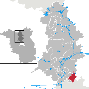
| Location of the municipality of Mühlenbecker Land in the Oberhavel district | ||
  |
||

Mühlenbecker Land is a municipality in the Oberhavel district in Brandenburg . It was created in 2003 through the merger of the four formerly independent municipalities of Mühlenbeck, Schildow, Schönfließ and Zühlsdorf.
geography
The community is located on the northern outskirts of Berlin .
Are neighboring communities
- in the south: Glienicke / Nordbahn , Berlin (district Lübars in the Reinickendorf district, Blankenfelde district in the Pankow district )
- in the east: Wandlitz (district Schönwalde )
- in the north: Oranienburg (district Wensickendorf )
- in the west: Hohen Neuendorf ( Bergfelde district ), Berlin ( Frohnau district in the Reinickendorf district), Birkenwerder ( Briese colony residential area )
Community structure
According to its main statute, the municipality is divided into four districts (population: January 1, 2019):
- Mühlenbeck (4216 inhabitants)
- Schildow (6535 inhabitants)
- Schönfließ (2256 inhabitants)
- Zühlsdorf (2260 inhabitants).
In addition, there are the residential areas Bieselheide, Buchhorst, Feldheim, Försterei Zühlslake, Groß-Stückenfeld, Lubowsee, Mönchmühle, Seefeld, Steinpfuhlsiedlung, Summt, Woltersdorf, Zühlsdorfer Mühle and Zühlslake .
history
The municipality of Mühlenbecker Land emerged on October 26, 2003 from the voluntary merger of the previously independent municipalities of Mühlenbeck, Schildow, Schönfließ and Zühlsdorf.
- On the history of Mühlenbeck
- On the history of Schönfließ
- On the history of Zühlsdorf
Population development
|
|
|
|
Territory of the respective year, number of inhabitants: as of December 31, from 2011 based on the 2011 census
politics
Community representation
The last election for the Mühlenbecker Land municipal council took place on May 26, 2019. The community council, consisting of 22 members and the full-time mayor, has been composed as follows since then:
| Party / list | Seats 2003 | Seats 2008 | Seats 2014 | Seats 2019 |
|---|---|---|---|---|
| SPD | 6th | 5 | 7th | 6th |
| CDU | 9 | 5 | 6th | 5 |
| Free voters Mühlenbecker Land | - | 2 | 2 | 4th |
| Alliance 90 / The Greens | 1 | 1 | 1 | 3 |
| THE LEFT | 3 | 5 | 3 | 2 |
| Action group Mühlenbecker Land | 2 | 1 | 1 | 1 |
| FDP | 1 | 2 | 1 | 1 |
| NPD | - | 1 | 1 | - |
| All in all | 22nd | 22nd | 22nd | 22nd |
In each of the four districts there is a local advisory committee, which consists of five people and takes care of local issues. The mayor is the chairman of the local advisory board.
mayor
- 2003–2011: Klaus Brietzke (CDU)
- since 2011: Filippo Smaldino (SPD)
Smaldino was elected on September 1, 2019 with 52.0 percent of the valid votes for a further term of eight years.
coat of arms
The coat of arms of the municipality was approved on October 26, 2005.
Blazon : "In the gold-bordered blue shield above a wave-shaped, silver-green divided wave shield base, a silver mill wheel."
The coat of arms was designed by the heraldist Frank Diemar .

Attractions
traffic
The federal road 96a between Berlin and Birkenwerder , the state road L 21 from the Schildow district to Zehdenick and the tourist route Deutsche Tonstraße run through the municipality. The closest motorway junction is Mühlenbeck on the A 10 (Berliner Ring).
The community is connected to the Berlin transport network via the S8 S-Bahn line. The Mühlenbeck-Mönchmühle and Schönfließ stations , which run parallel to the Berlin outer ring , are located in the municipality . The Mühlenbeck-Mönchmühle stop went into operation on September 2, 1984; a passimeter building at the eastern end of the platform was demolished in 2009 due to constant vandalism.
In the district of Zühlsdorf, the regional train line RB27 Wensickendorf - Berlin-Karow stops at the Heidekrautbahn stop of the same name . The Mühlenbeck station was built at the beginning of the 20th century with the establishment of the rail connection between Berlin-Wilhelmsruh and Großschönebeck or Liebenwalde, it has a simple cube-shaped reception building. The trains used in museum traffic do not stop here.
The BVG bus line 107 and the OVG bus lines 806, 809 and 810 run in the village ; the district of Zühlsdorf also has a connection to Wandlitz in the neighboring district of Barnim with the bus line 891 of the Barnim bus company .
Personalities
Sons and daughters of the church
- Sophie Marie von Pannwitz (1729–1814), Prussian lady-in-waiting, born in Schönfließ
- Erwin Lambert (1909–1976), master bricklayer, involved in the expansion of concentration camps, born in Schildow
Personalities associated with the community
- Leopold Krug (1770–1843), national economist, lived in Mühlenbeck
- Werner von Veltheim (1843–1919), Prussian politician, lived in Schönfließ
- Ernst Thrasolt (1878–1945), rescuer of the Jews , lived in Schildow
- Martin Ziegler (1931–2015), theologian, moderator of the Central Round Table in the GDR , lived in Schildow
- Thomas Lück (1943–2019), pop singer, lived in Schildow
- Walter Libuda (* 1950), painter, lives in Schildow
- Paul Schmidt-Hellinger (* 1985), doctor and long-distance runner, lives in Schildow
literature
- Roland Lampe: "Nevertheless, the house enchanted me ..." - On the trail of well-known and unknown authors in Oberhavel . Tredition Hamburg 2017. ISBN 978-3-7439-5033-7 .
Web links
Individual evidence
- ↑ Population in the State of Brandenburg according to municipalities, offices and municipalities not subject to official registration on December 31, 2019 (XLSX file; 223 KB) (updated official population figures) ( help on this ).
- ↑ Main statute of the municipality of December 16, 2008 (PDF)
- ↑ Numbers and facts. Mühlenbecker Land community, accessed on May 26, 2020 .
- ^ Service portal of the state administration Brandenburg - Mühlenbecker Land community
- ^ Historical municipality register of the state of Brandenburg 1875 to 2005. Oberhavel district . Pp. 18-21
- ↑ Population in the state of Brandenburg from 1991 to 2015 according to independent cities, districts and municipalities , Table 7
- ^ Office for Statistics Berlin-Brandenburg (Ed.): Statistical report AI 7, A II 3, A III 3. Population development and population status in the state of Brandenburg (respective editions of the month of December)
- ^ Result of the local election on May 26, 2019
- ^ Result of the mayoral election on September 25, 2011
- ↑ Brandenburg Local Election Act, Section 74
- ^ Result of the mayoral election on September 1, 2019
- ↑ Coat of arms information on the service portal of the state administration of Brandenburg
- ^ Mühlenbeck-Mönchmühle , History and Stories about the Berlin S-Bahn , accessed on August 11, 2015.