Mittelheim
|
Mittelheim
City of Oestrich-Winkel
|
|
|---|---|
| Coordinates: 50 ° 0 ′ 7 ″ N , 8 ° 0 ′ 58 ″ E | |
| Height : | 94 m above sea level NHN |
| Area : | 5.75 km² |
| Residents : | 1299 (December 29, 2015) |
| Population density : | 226 inhabitants / km² |
| Incorporation : | July 1, 1972 |
| Postal code : | 65375 |
| Area code : | 06723 |
Mittelheim is a district of Oestrich-Winkel in the Rheingau-Taunus district in southern Hesse .
geography
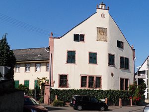
Mittelheim is the middle of the three districts on the Rhine, Oestrich , Mittelheim and Winkel . It is structurally connected to Winkel in the west. The place has developed along the old road leading in east-west direction through the Rheingau and the short alleys running across it over a length of 500 meters. Due to this construction, Mittelheim has no recognizable center. In general, the square is seen as the center of the village, where the passage makes a bend and a house with a Renaissance gable becomes an eye-catcher. However, the old town hall and the church cannot be found here.
The Mittelheim district stretches as a strip from the navigation channel of the Rhine about 3.5 kilometers as a gusset to the edge of the forest. The width of the district is usually no more than 800 meters. Since the development of Mittelheim and Winkel merges, the boundary between the two districts is completely imperceptible. It is located about 100 meters east of the Engerweg , a road connection that leads from the bank of the Rhine through a railway underpass to the building areas above the right-hand Rhine route. The forest area of Mittelheim is located as an exclave between the forests of Oestrich and Hallgarten . The Mittelheimer Wald is a strip 7 kilometers long and about 500 meters wide, which begins between the Philippsburg hunting lodge and the Susberg and extends over the Ernstbach into the hinterland forest .
Mittelheim is surrounded on all sides by vineyards. There are still individual vineyards between the town and the Rhine. To the east towards Oestrich and to the north to the edge of the forest, viticulture predominates as an agricultural type of use.
history
The first preserved documentary mention of the place as Mittelheim dates from 1292. At this time the place with the whole Rheingau is part of the Kurmainzian territory. In 1386 Archbishop Adolf I of Nassau separates Mittelheim as an independent community from Oestrich. After the dissolution of the Electoral state the place in 1803 went to Nassau-Usingen and belonged to the time of the Duchy of Nassau for Office Eltville . After the annexation of the duchy by Prussia , the place was assigned to the Rheingau district in the Wiesbaden administrative region in 1867 .
In the course of the regional reform in Hesse , the municipality of Mittelheim with about 1000 inhabitants became the smallest district in the city of Oestrich-Winkel, which was newly formed on July 1, 1972 through a voluntary merger with the municipalities of Oestrich and Winkel . The coat of arms of Mittelheim was adopted unchanged as the city coat of arms of Oestrich-Winkel. Local districts with local councils and local councilors were formed for all city districts .
coat of arms
On September 27, 1965, the municipality Mittelheim in the former was Rheingaukreis , Region of Wiesbaden , a coat of arms with the following Blazon awarded: In a perverse Red Silver Z, both sides accompanied by a gold star.
Culture and sights
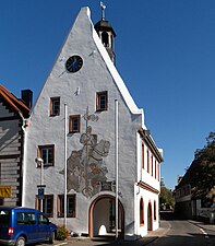
The Catholic St. Aegidius Basilica is an eye-catcher from the Rhine and the B 42 bypass , while the old town hall is an eye-catcher when driving through town.
The modern Evangelical Church from 1956 is located on the Rhine in the direction of Oestrich .
At the parking lot next to the basilica, the location of the 50th degree of latitude is marked on a boulder with a view of the Jesuitengarten vineyards in Winkel.
Location of the 50th parallel according to the World Geodetic System 1984 (WGS84) at the parking lot of the Tourist Information. According to the Potsdam date assumed for topographic maps in Germany, the 50th parallel is here about 130 meters further south.
traffic
When the right Rhine route was built, the communities of Oestrich and Winkel could not agree with the railway company on the locations of the railway stations. And so the railway built a train station in the small Mittelheim and called it Oestrich-Winkel, generations before it was thought of uniting the three communities under this name as part of the regional reform.
From Mittelheim the ferry connection "Michael" goes to river kilometer 519 for cars to Ingelheim am Rhein ; The access under the main road is too low for trucks.
Personalities
- Philipp Gersenius (1665-1727); Jesuit , cathedral preacher in Würzburg, university lecturer in Würzburg and Bamberg, from 1723 rector of the Jesuit college in Speyer
literature
- Dietel, Klaus Peter. When the nobleman took the maiden. History and stories of regional reform in the Rheingau. ASSverlag, Rüdesheim am Rhein 1997
- Literature about Mittelheim in the Hessian Bibliography
Web links
- Districts In: Website of the city of Oestrich-Winkel.
- Winkel, Rheingau-Taunus-Kreis. Historical local dictionary for Hessen. In: Landesgeschichtliches Informationssystem Hessen (LAGIS).
Individual evidence
- ^ Winkel, Rheingau-Taunus-Kreis. Historical local dictionary for Hessen. (As of October 16, 2018). In: Landesgeschichtliches Informationssystem Hessen (LAGIS).
- ↑ Extract from the registration office as of December 29, 2015: Population figures in Oestrich-Winkel
- ^ Hessian Land Surveying Office: District map 1: 50,000 Wiesbaden Rheingaukreis Untertaunuskreis, edition 1969
- ↑ Karl Menzel and Wilhelm Sauer, eds., Codex diplomaticus Nassoicus, Nassauisches Urkundenbuch, Vol. 1: The documents of the former Electoral Mainz area, including the dominions of Eppenstein, Königstein and Falkenstein, the Niedergrafschaft Katzenelnbogen and the Electoral Palatinate Office of Caub, edited. by Wilhelm Sauer, Wiesbaden 1886, pp. 675–676, no. 1144
- ^ Municipal reform in Hesse: mergers and integrations of municipalities from June 21, 1972 . In: The Hessian Minister of the Interior (ed.): State Gazette for the State of Hesse. 1972 No. 28 , p. 1197 , point 851 para. 3. ( Online at the information system of the Hessian State Parliament [PDF; 4.4 MB ]).
- ^ Federal Statistical Office (ed.): Historical municipality directory for the Federal Republic of Germany. Name, border and key number changes in municipalities, counties and administrative districts from May 27, 1970 to December 31, 1982 . W. Kohlhammer, Stuttgart / Mainz 1983, ISBN 3-17-003263-1 , p. 375 .
- ↑ main statute. (PDF; 108 kB) §; 4. In: website. City of Oestrich-Winkel, accessed February 2019 .
- ↑ Approval of a coat of arms of the community Mittelheim, Rheingaukreis, administrative district Wiesbaden from September 27, 1965 . In: The Hessian Minister of the Interior (ed.): State Gazette for the State of Hesse. 1965 no. 42 , p. 1207 , point 1007 ( online at the information system of the Hessian state parliament [PDF; 4.5 MB ]).


