Barhal
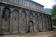
Barhal , also Altıparmak, Parhal; Georgian : პარხალი, Parchali, Parkhali, is a mountain village on the southern slope of the Eastern Pontic Mountains ( Kaçkar Dağları ) in the Artvin province in northeastern Turkey . The church of Barhal ( Barhal Kilisesi ), now used as a mosque , is a former monastery church from the 10th century that belonged to the medieval Georgian kingdom of Tao-Klardschetien .
Location and townscape
Coordinates: 40 ° 58 ′ 15 ″ N , 41 ° 22 ′ 26 ″ E
The Kaçkar Dağları mountain ranges, which run parallel to the coast of the Black Sea , are among the wettest areas in Turkey. The mountains reach a height of 3600 meters a few kilometers north of Barhal and drop steeply to the south to the valley of the Çoruh river. Numerous small and large brooks flow to the Çoruh through the mountain valleys that open towards the southeast.
From the expressway between Artvin and Erzurum , a side road branches off to the west, which, following the course of the Çoruh upstream towards İspir , reaches Yusufeli after ten kilometers . Yusufeli is the capital of the district of the same name and the starting point of a 27-kilometer-long narrow mountain road that leads in the valley of the Barhal Çayı (left tributary of the Çoruh) to the northwest from about 700 meters to Barhal at an altitude of 1250 meters. Apart from a few farmsteads, the street village of Sarıgöl is the only larger settlement in the valley on two thirds of the route.
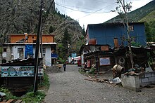
The center of Barhal lies at the confluence of a stream coming from the north into the Barhal Çayı, and the road forks accordingly. Behind the mosque to the right, i.e. in the side valley to the north, there is a gravel path, from which after a kilometer at a junction on the right, after a few meters, the church of Barhal can be seen at the top of the slope. Further along the road there are still individual farms belonging to Barhal. The path later leads through coniferous forest and up to the meltwater lake Karagöl below a 3300 meter peak. The road over the bridge in the center of Barhal to the west reaches the village of Yaylalar at an altitude of 2100 meters after 24 kilometers. At least one minibus runs daily from Yusufeli via Barhal to Yaylalar.
There are grocery stores with a seasonal range of fruit and vegetables, several tea rooms, a new mosque and three guest houses. Agriculture is determined by keeping cattle. Each homestead has a farm building, on the brick ground floor of which the cattle are kept at night and all day in winter. Above there are one or two floors, mostly made of wooden boards, where hay and other cattle feed is stored as a reserve for the long winter months. Corn, fodder clover, tomatoes, cucumbers and aubergines are grown on terraced fields. Walnuts, persimmons , pomegranates and grapes also thrive .
After the heavy rains in the winter months, the Barhal River is suitable for white water rides in spring, which are offered by tour operators. The groups spend the night mostly in Barhal. The first 12 kilometers downriver from here to Sarıgöl are classified as challenging, the further 16 kilometers to Yusufeli are easier to drive. In addition, Barhal is the best-known starting point for hikes in the Kaçkar Mountains when coming from the south. The season for summit ascents and crossings is from July to mid-August. The number of inhabitants is declining despite the income from the tourism business. For the year 2000 745 inhabitants were given, in 2010 it was 469.
Barhal Church
history
Numerous churches and monasteries were built in Tao-Klardschetien in the 9th and 10th centuries. The church of Barhal is a very similar, in the architectural sculpture, simplified replica of the Dörtkilise located in another mountain valley , for which construction began around 960 (after 961), shortly before or at the beginning of the reign of David III. , David the Great (r. 961–1000). Accordingly, construction of the church must have started in the 960s. An inscription on the south facade names David as the donor. It was completed in 973 at the latest. This date is in a manuscript called "Barhal Bible", which was copied in a monastery called Schatberdi (presumably to be equated with the preserved church ruins Yeni Rabat near Ardanuç ) and in which the new building of the Barhal monastery is mentioned. Two chapels nearby are dated to the same founding time.
The portico in front of the south side, which has now disappeared , was built by King Alexander (r. 1412–1442). According to an inscription inside, the church was restored during the tenure of Patriarch John (1489–1507). The sunken porch ( narthex ) in the west dates from the beginning of the 16th century. A public announcement of the Ottoman rule from 1677 indicates that the church had been converted into a mosque. The Georgian historian Ekwtime Taqaishvili described Barhal in 1917 as well as the other Georgian churches in Turkey. The building is still used as a mosque today and is usually locked.
Design
The three- aisled basilica measures 28.4 × 18.7 meters and has exactly the same footprint as the Dörtkilise. It rises above a two-tiered base zone, each 22 centimeters high. The barrel vaults of the nave are supported by four pairs of pillars; A high gallery is built between the western pillars. On the east side, within the straight outer wall, the semicircular apse is flanked by two rectangular, two-storey side rooms ( pastophoria ). As in Dörtkilise, the second zygomatic arch in front of the chancel is widened, but here the desired spatial impression of a transept was planned from the start.
The outer walls are clad with neatly joined, gray sandstone slabs. The roof is not covered with clay tiles, but also with gray stone slabs. The vertical division of the outer walls is done by uniform blind niche arcades that are continued in the same line on the upper arcade . On the superstructure, the blind arches rest on unadorned double pillars, while the Dörtkilise pillars are artfully twisted in a spiral. The height of the blind arches on the gable sides is adapted to the shape of the roof, the middle one is slightly wider and contains the only large window on the east side and the entrance to the west, which can be found today in the darkness of the half-ruined extension. The wall fields are uniformly 1.88 meters wide, only at the entrances were they enlarged to 2.38 meters. The original portals in the two longitudinal walls are now walled up. All three entrances were 1.86 meters wide and 2.8 meters high.
The architectural decorations are greatly reduced compared to Dörtkilise, and not only the blind arches are simple. Simple, but finely designed, arched beads can be found above some of the windows on the long sides. On the west facade, a small relief above the northern window depicts a person praying in an ornamental position , the inscription "Theodor" probably refers to the builder. A pair of peacocks and a lion facing each other can be seen in the arched fields on the north side. Most of the other shapes are geometric or floral ( palmettes ). Apart from such decorations, the outer walls are smooth, the gray hue makes the building, wedged between high mountains, appear somewhat gloomy.
The original frescos in the apse have been painted over. On the second pair of pillars from the east there are seating niches facing the altar. A relief in the southern niche shows, together with an angel, a figure who can be interpreted as a columnist Symeon . Some details inside are even finer than in the original, for example an arched niche under the window in the apse.
As with the other monasteries, there were outbuildings in the vicinity. The ruins of a small chapel with an adjoining room on the north side have been preserved on a mountain slope 1.5 kilometers to the south. A hall church with the external dimensions 7.5 × 5.2 meters and a round apse was there at the top of the mountain.
In addition to Barhal, the best-preserved Georgian churches in the Dörtkilise region, İşhan east of Yusufeli, and Öşk Vank and Haho , which can be reached from the main road between Yusufeli and Tortum .
literature
- Wachtang Djobadze: Early Medieval Georgian Monasteries in Historic Tao, Klardjetʿi and Šavšetʿi. (Research on art history and Christian archeology, XVII) Franz Steiner, Stuttgart 1992, pp. 178–190
- Volker Eid : East Turkey. Peoples and cultures between Taurus and Ararat . DuMont, Cologne 1990, pp. 195f, ISBN 3-7701-1455-8
- Vera and Hellmut Hell: Turkey. Northern Turkey, Eastern Turkey, Southeast Turkey. Kohlhammer, Stuttgart a. a., 3rd ed. 1988, p. 102
- Thomas Alexander Sinclair: Eastern Turkey: An Architectural and Archaeological Survey. Vol. II. The Pindar Press, London 1989, pp. 16f
- Anna V. Zakharova, Svetlana V. Mal'tseva: The Materials of Nikolai Okunev's Expedition of 1917 on the Wall Paintings of Parkhali. In: SV Mal'tseva, E. Iu. Staniukovich-Denisova, AV Zakharova (Ed.): Actual Problems of Theory and History of Art: Collection of articles. Vol. 7, St. Petersburg University Press, St. Petersburg 2017, pp. 679–688
Web links
- Monastery of Barhal (Parhali). choruh.com


