
Barm
|
Barm
Dörverden municipality
|
||
|---|---|---|
 |
||
| Height : | 18 m above sea level NN | |
| Area : | 52.3 ha | |
| Residents : | 1100 | |
| Population density : | 2,103 inhabitants / km² | |
| Incorporation : | July 1, 1972 | |
| Postal code : | 27313 | |
| Area code : | 04234 | |
Location of Barme in Lower Saxony |
||

Barme is a village and district of Dörverden , which lies on the southern border of the Verden district on the right bank of the Weser .
The place consists of the districts Barme, Barme am Walde and Altbarme. In Altbarme there are a few farms, in the other two districts mainly residential buildings. There are extensive asparagus fields around Barme .
history
The oldest archaeological finds indicate the first settlement in the younger Stone Age (around 4000–2000 BC). The many barrows also bear witness to the very early settlement of the area. Excavations carried out in a Weser Rand dune between 1956 and 1958 showed that the cemetery found there was obviously used from the earliest Iron Age (around 800 BC) to the 10th century AD. Another historical relic are the remains of a medieval moth in the forest, which testify to the location of Barmes on an earlier Landwehr .
In the time of National Socialism there was a large explosives factory near Barme, the Weser der Eibia plant . Even today, streets, railway lines, buildings and bunkers as well as the enclosure of the entire facility are clearly visible. Forced laborers were also used as workers for production .
On the site of the former Eibia, the Lower Saxony barracks was built for the German armed forces in 1958 , and up to 4,000 soldiers were stationed there. The Bundeswehr base in Barme was closed on September 30, 2003. Since the first troop reductions, the district has lost almost a third of its inhabitants. The Lower Saxony barracks was demolished in 2012/13.
With the regional reform on July 1, 1972, Barme was combined with four other places to form the municipality of Dörverden.
Part of the former Bundeswehr site, the so-called Heisenhof , was transferred to the right-wing extremist Wilhelm Tietjen Foundation for Fertilization Ltd. after the garrison was dissolved . sold. In October 2011 the entire area was sold to a businessman by the Wilhelm Tietjen Foundation.
On a site on the edge of the former barracks that was in April 2010 Wolf Center opened, a wildlife park, which wants others to the population to become extinct in Germany in the 20th century Wolf.
In 2007 the local Evangelical Lutheran Church of St. George was handed over to an Evangelical Free Church.
On the southern part of the former barracks site, the HF Wiebe company installed a storage facility ( track harp ) for its rail construction trains in 2015 .

Memorial stone to the former barracks

Wolf Center Wildlife Park

Sidings from HF Wiebe
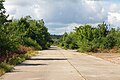
View of the former barracks
_IMG_9254.jpg)
_IMG_8912.jpg)

_IMG_8917.jpg)
politics
Mayor is Vladimir Sabelfeld.
coat of arms
Blazon : “In silver a green ferry boat moving to the right, which has a silver 'B' in the green sail; In the green shield head with a wavy base, two silver oak leaves surround a silver acorn. "
The ferry boat refers to the Weser crossing that has existed for centuries at this point, which connects the Barmer property on both sides of the Weser. The sail is reminiscent of the many sailing boats that used to regularly moor in Barme over the weekend. The oak leaves point to the old oak stocks on the banks of the Weser, just as the wavy line refers to the Weser, which, as a silver band next to the green bank, establishes the colors green-silver.
The design of the coat of arms was created by Heinz Bannier, Dörverden.
See also
Web links
- Barme on the homepage of the municipality Dörverden
- Homepage of the municipality of Dörverden
- Eibia GmbH - "Weser" plant, description and photos
- Traditionskreis Raketenartilleriebataillon 32 / Begleitbatterie 3 eV
Individual evidence
- ^ Federal Statistical Office (ed.): Historical municipality directory for the Federal Republic of Germany. Name, border and key number changes in municipalities, counties and administrative districts from May 27, 1970 to December 31, 1982 . W. Kohlhammer GmbH, Stuttgart and Mainz 1983, ISBN 3-17-003263-1 , p. 247 .
Ahnebergen | Barme | Barnstedt | Service shop | Dörverden | Sleeves | Stedebergen | Stedorf | Wahnebergen | west