Berglen (landscape)
| The mountains | |
|---|---|
|
The Berglen southwest of the |
|
| Highest peak | Buocher Höhe ( 519.6 m above sea level ) |
| location | Rems-Murr-Kreis , Baden-Württemberg (Germany) |
| Orographically foothills of the | Swabian-Franconian Forest |
| Coordinates | 48 ° 50 ' N , 9 ° 27' E |
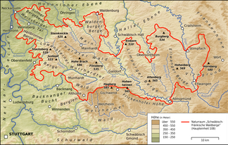
The Berglen are a wooded mountain landscape in the Rems-Murr-Kreis . They belong to the natural spatial main unit Schurwald and Welzheimer Wald (107) and have the code number 107.2 (0). However, they stand to the northeast over the narrow ridge that separates the villages of Rudersberg in the southeast in the Wieslauftal and Allmersbach in the northwest in the Murr valley bay , in a narrow connection with the Swabian-Franconian forest mountains (108). To the south and east, the Remstal natural area (107.1) with the Schorndorfer Basin forms a clear demarcation from the higher Keuper landscapes of the main unit; in the south the valley of the Rems itself separates from the Schurwald (107.0) , in the east from the Welzheimer Wald (107.3) the side valley of its largest tributary, the Wieslauf .
In the west, the "heads" Kleinheppacher Kopf , Hörnles-Kopf and Korber Kopf rise from the gullies . This is followed by the Buocher Höhe to the east , at 519.6 m near the village of Buoch the highest point in the mountains. In the north, Winnender and Backnanger Bay border the Berglen. The mountains are mainly drained to the northwest, to a lesser extent in the west by the Zipfelbach , to the east and mainly by the Buchenbach , which rises in the northeast and only follows its extensive drainage direction after a knee in the center of the landscape. Of the streams draining southwards, the Schornbach, which flows out at Schorndorf, is of some importance.
The municipality of Berglen was named after the landscape.
Geology and landscape
Due to the geological to the imminent there layers of the Keuper the Berglen is forest on the hills, on the slopes there are numerous orchards and on the southern z. B. in Weinstadt and Korb wine is also grown. In the valleys in Gipskeuper there are often cold air lakes , so that only meadow management is possible. A special culture native to the mountains is strawberry cultivation, which was introduced in Breuningsweiler around 1900 .
Individual evidence
- ↑ Schurwald and Welzheimer Wald natural area profile (107) - LUBW (PDF; 9.1 MB; notes )
- ↑ Hansjörg Dongus: Geographical land survey: The natural spatial units on sheet 171 Göppingen. Federal Institute for Regional Studies, Bad Godesberg 1961. → Online map (PDF; 4.3 MB)
