Bißnitz
| Bißnitz | ||
|
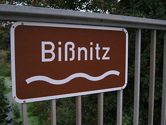
Sign for the Bißnitz between Steinbek and Geschendorf in the Segeberg district. |
||
| Data | ||
| location | Schleswig-Holstein , Germany | |
| River system | Trave | |
| Drain over | Trave → Baltic Sea | |
| River basin district | Schlei / Trave | |
| source | at Rehhorst 53 ° 52 ′ 23 ″ N , 10 ° 28 ′ 9 ″ E |
|
| Source height | 54 m above sea level NN | |
| muzzle | in the Wardersee coordinates: 53 ° 57 ′ 13 ″ N , 10 ° 27 ′ 20 ″ E 53 ° 57 ′ 13 ″ N , 10 ° 27 ′ 20 ″ E |
|
| Mouth height | 24.9 m above sea level NN | |
| Height difference | 29.1 m | |
| Bottom slope | approx. 1.9 ‰ | |
| length | approx. 15 km | |
| Left tributaries | Steinbek | |
The Bißnitz is an approximately 15 km long stream in the Stormarn and Segeberg districts , which belongs to the Trave river system and flows into the Wardersee .
course
It arises from several drainage ditches near the municipality of Rehhorst in the Stormarn district . About 10 km after its creation, it is fed by the Steinbek near Söhren and flows into the Wardersee near Pronstorf . The Bißnitz is not suitable for shipping.

Flora and fauna
The Bißnitz is mostly a small stream that contains the following types of fish: rudd , roach (roach), bream (or lead, bream ), perch , sticklebacks , occasionally brown trout , crucian carp , tench and carp . In spring, pike migrate through the Bißnitz into the Steinbek to spawn there in draining ditches and flooded meadows.
Individual evidence
- ↑ a b Archive link ( Memento of the original dated August 7, 2011 in the Internet Archive ) Info: The archive link was inserted automatically and has not yet been checked. Please check the original and archive link according to the instructions and then remove this notice.
