
Bolungarvík

|
|
| Basic data | |
|---|---|
| State : |
|
| Region: | Vestfirdir |
| Constituency : | Norðvesturkjördæmi |
| Sýsla : | circular |
| Population: | 953 (January 1, 2019) |
| Surface: | 109 km² |
| Population density: | 8.74 inhabitants / km² |
| Post Code: | 415 |
| politics | |
| Community number | 4100 |
| Mayor: | Jón Páll Hreinsson |
| Contact | |
| Address of the municipal administration: | Aðalstræti 12 415 Bolungarvík |
| Website: | www.bolungarvik.is |
| map | |

Coordinates: 66 ° 10 ′ N , 23 ° 15 ′ W |
|
The town of Bolungarvík ('Holzhaufenbucht', Icelandic Bolungarvíkurkaupstaður ) is a municipality in the Vestfirðir region in the far northwest of Iceland . On January 1, 2020, the community had 955 inhabitants.
geography


In terms of population, Bolungarvík is the second largest town in the Vestfirðir region after Ísafjörður, which is 13 kilometers southeast . Overlooked by the steep slopes of the striking Traðarhorn , Bolungarvík lies on the small bay of the same name, which belongs to the largest fjord in the region, the Ísafjarðardjúp .
Above the village is the 638 m high mountain Bolafjall .
history


Bolungarvík has always been of great importance as an important fishing spot since the time of the conquest . In this area it was a clan chief, Þuriður sundafyllir , who took possession of the land around Bolungarvík with her son Völundar-Steinn . A memorial was erected to her in 1975 by women from the village.
The formerly most important and richest farm called Hóll , which, as is often the case in Iceland, was also the vicarage, is located on a hill (= isl.
Fishing has always been the town's main source of income, and the bay was home to many fishermen's huts until the end of the 19th century, mainly used during the winter fishing season.
A shop was opened at the end of the 19th century, and from 1903 the place received market rights. In the years 1917–1921, lignite was mined in the Gilsnáma mine in the nearby Syðridalur valley . In 1932 a swimming pool was built, which was initially heated with coal and was the first such swimming pool in the country. A new one was put into operation in 1977.
In 2003, Bolungarvík was the location of Nói Albínói , a film by Dagur Kári .
Culture and sights


Unlike the nearby Ísafjörður, Bolungarvík has more of the character of a fishing village, but impresses with its almost alpine landscape.
The natural history museum , attached to the natural history institute , deserves a special mention . The various exhibits testify to the biodiversity of the region, and there is also information on the natural area of Hornstrandir , the region north of Ísafjarðardjúp .
The bright, corrugated iron roofed church Hólskirkja from 1908 is located above the village on the Hóll 'hill'.
The reconstructed fishing hut Ósvör at the eastern end of the bay (Icelandic vík ) is designed as an open-air museum . The replicas of the residential and workhouses bear witness to the time when rowing boats were still used here. Also worth seeing is the small, bright orange lighthouse Óshólaviti from 1937 above Ósvörs .
A rough jeep track, which is open to cars in July and August, leads to Bolafjall above the village. Above is a now unmanned radar station that was operated by the US Army as part of NATO until 2006 and has been under the Icelandic Coast Guard since then. If the weather conditions are right, you can see far over the mouth of the Ísarfjarðardjúp fjord and to Hornstrandir .
On snowy winter days there are groomed trails for cross-country skiers near the village. In the mountains of the area there are numerous opportunities for mountaineering and hiking.
Economy and Services
Despite the rather disadvantageous port location, fishing and processing are still the most important source of income for the place due to the rich fishing grounds. There are also other local employers, some of them shops and craft businesses, but also tourism facilities such as hotels and museums. The focus is now increasingly on tourism, for example the open-air fishing museum Ósvör .
Deep sea fishing tourism is a growing industry in Bolungarvík and offers more jobs, at least in summer.
There is a kindergarten, a primary school, a music school and sports facilities with a swimming pool on site. There is also a community library, a multipurpose community center and a health center.
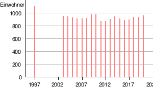
Population development
Bolungarvík, like many remote regions in Iceland, is particularly affected by migration to the capital region.
| date | Residents |
|---|---|
| Dec 1, 1997 | 1,094 |
| Dec. 1, 2003 | 944 |
| Dec. 1, 2004 | 934 |
| Dec 1, 2005 | 918 |
| Dec 1, 2006 | 905 |
| Dec. 1, 2007 | 904 |
From 2007 the data are available for January 1st.
| date | Residents |
|---|---|
| Jan. 1, 2008 | 908 |
| Jan. 1, 2009 | 966 |
| Jan. 1, 2010 | 970 |
| Jan. 1, 2011 | 865 |
| Jan. 1, 2012 | 866 |
| Jan. 1, 2013 | 894 |
| Jan. 1, 2014 | 933 |
| Jan. 1, 2015 | 906 |
| Jan. 1, 2016 | 882 |
| Jan. 1, 2017 | 888 |
| Jan. 1, 2018 | 924 |
| Jan. 1, 2019 | 931 |
| Jan. 1, 2020 | 955 |
The population decline from December 1, 1997 to January 1, 2020 is 12.7%.
traffic
The Djúpvegur, the national road 61, has been connecting Bólungarvík with Ísafjörður since 1950.
Since September 26, 2010, Bolungarvik has been safer to reach through the Bolungarvíkurgöng tunnel than before via the path along the steep coast at Óshlíð, which is notorious for its avalanches .
From Bolungarvík, the dirt road 630 leads west into the now uninhabited bay of Skálavík . However, due to snow conditions, the road is usually only open to car traffic from July 1st (and usually only until August 31st) (just like the junction on Mount Bolafjall); the current road conditions can be viewed online.
The distance to the capital Reykjavík is about 470 kilometers.
Personalities
- Einar K. Guðfinnsson (* 1955), Icelandic politician
- Andri Rúnar Bjarnason (* 1990), national soccer player
Web links
- Local government website (Icelandic)
- Bolungarvík in Nat.is (English)
- Bolungavík, Travelnet.is (English)
- Ósvör Museum
See also
Individual evidence
- ↑ bulungr . In: Richard Cleasby, Guðbrandur Vigfússon (Ed.): An Icelandic-English Dictionary . Oxford 1874, p. 86 ( online )
- ^ Hagstofa (Statistical Office of Iceland) (Icelandic); Accessed April 25, 2020
- ↑ a b c d e f g Íslandshandbókin. Náttúra, saga og sérkenni. 1. bindi. Edited by T. Einarsson, H. Magnússon. Örn og Örlygur, Reykjavík 1989, 265
- ^ HU Schmid: Dictionary Icelandic - German. Buske, Hamburg, 110
- ↑ cf. also: Information about the farm ( page no longer available , search in web archives ) Info: The link was automatically marked as defective. Please check the link according to the instructions and then remove this notice. (Icelandic); Accessed August 7, 2011
- ↑ Noi the Albino. Frumraun Dags Kára Péturssonar í fullri lengd. In: Morgunblaðið. February 23, 2001, Retrieved August 3, 2011 (Icelandic).
- ↑ cf. z. B. Off. tourist. Website ( Memento of August 9, 2011 in the Internet Archive ) (English); Accessed August 3, 2011
- ↑ cf. z. B. Vegurinn upp á Bolafjall opnaður. BB, July 4, 2002, archived from the original on October 18, 2014 ; Retrieved August 7, 2011 (Icelandic).
- ↑ Gönguskíðabraut troðin. (No longer available online.) In: www.bolungarvik.is. Bolungarvíkurkaupstaður municipality, February 13, 2008, formerly in the original ; Retrieved March 1, 2014 (Icelandic). ( Page no longer available , search in web archives )
- ↑ Hiking maps of the area ( Memento of November 8, 2014 in the Internet Archive ) (PDF file) (Icelandic); Accessed August 7, 2011
- ↑ cf. z. B. Overview map of trails in the Hnífsdalur and Ísarfjörður area (Icelandic); Accessed August 7, 2011
- ↑ Iceland Sea Angling (mainly German); Accessed May 24, 2012
- ↑ cf. z. B. Off. Congregation website ( September 20, 2011 memento on Internet Archive ) (Icelandic); Accessed August 7, 2011
- ↑ cf. Hagstofa (Statistical Office of Iceland) (Icelandic); Accessed April 25, 2020
- ↑ a b Vegahandbókin. Ed. Landmælingar Íslands, 2006, 294
- ↑ Bolungarvíkurgöng opnuð í dag. In: RÚV. September 25, 2010, archived from the original on March 5, 2014 ; Retrieved March 1, 2014 (Icelandic).
- ^ Icelandic Road and Coastal Administration: Road conditions and weather. June 16, 2015, accessed June 16, 2015 .