
Vestfirdir
| Vestfirdir | |
 map |
|
| Geographical location | |
 |
|
| Coordinates | 65 ° 44 ′ N , 22 ° 10 ′ W |
| Waters 1 | Húnaflói , Atlantic Ocean |
| Waters 2 | Breiðafjörður |
| surface | 9 409 km² |
 Bolungarvík at Ísafjarðardjúp |
|
The Vestfirðir ( German Westfjords ) encompass a peninsula and region with an area of 9409 km² in the north-west of Iceland .
European arctic
Vestfirðir is only connected to the “real” Iceland by a narrow neck of land. The peninsula is surrounded in the northwest by the Denmark Strait (Isl. Grænlandssund ) and in the northeast by the Greenland Sea . The Westfjords make up around 30% of the entire coastline of Iceland.
The eponymous fjords in the west extend deep into the country and jagged the inhospitable area. The land routes through the fjords are very long. There and back trips in one day are hardly possible. In severe weather and snow, the gravel roads are often impassable. Shelters with telephones and food can save lives. Nevertheless, domestic freight transport depends on the roads because there are no ferries . The boat trip is solely the fish processing industry in the remote port cities. Small planes can land on unfired gravel runways.
At the beginning of the 17th century, the Basques were the first European whalers to come to the Westfjords and set up fishing stations there. They used a mixture of Basque and Icelandic to communicate with Icelanders . They were followed by Norwegians , English , French , Dutch , Spanish and Germans .
Important places
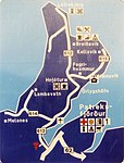
The most important places in the region are Ísafjörður and Bolungarvík . Also of importance are Þingeyri , Patreksfjörður , Suðureyri and Hólmavík , Tálknafjörður , Flateyri , Súðavík , Hnífsdalur , Bíldudalur , Reykhólar and Reykjanes .
population
The region is relatively sparsely populated with a total of 7,374 inhabitants (December 1, 2008), which corresponds to less than 3% of the total Icelandic population (around 1900 still around 16%) and a population density of 0.784 inhabitants / km².
The reasons for this extreme rural exodus lie on the one hand in the relatively isolated location of the individual places and on the other hand in the declining demand for labor in the agricultural and fishing industries, which are the main sources of income in the Westfjords. Transport connections are still relatively difficult today (especially in winter). Many roads consist only of gravel roads. And the often rainy or stormy weather hinders air traffic (to Ísafjörður and Gjögur ). The northern Hornstrandir peninsula is even completely uninhabited in winter.
Many people move to the capital region or emigrate to other countries, for example after an avalanche disaster in 1995 (see also: Súðavík ). In the second half of 2008, a direct reversal of the previous trend was discernible for the first time in a long time. While Vestfirðir, like most other regions far from the capital, has seen a more or less significant increase in population, the regions in and around the capital in the south-west, which have been growing until then, are clearly losing inhabitants. It remains to be seen whether this is related to the financial crisis, the banks concentrated in the metropolitan areas and a return to the “old Icelandic way of life”, or whether it is just a temporary phenomenon.
tourism
In the meantime, tourism is being expanded as a new line of business, as the fjords are very scenic. The area near the Dynjandi (also Fjallfoss ), the 100 m highest waterfall in the Westfjords, is not very well developed for tourism . Since 2006, fishing tourism in the Westfjords has increased significantly. The sea area at the exit of the Ísafjarðardjúp ice fjord offers very good opportunities for fishing for cod , halibut , wolffish and sometimes haddock , saithe and redfish .
Division into districts and municipalities
The Vestfirðir region is divided into four districts and two municipalities. The former Vestur-Ísafjarðarsýsla district (code no. 4700) has now been completely incorporated into the Ísafjarðarbær municipality .
| Code no. | Independent municipality | Residents 2006 | Area [km²] | Administrative headquarters |
|---|---|---|---|---|
| 4100 | Bolungarvíkurkaupstaður | 905 | 109 | Bolungarvík |
| 4200 | Ísafjarðarbær | 4,109 | 2,379 | Ísafjörður |
| Code no. | circle | Residents 2006 | Area [km²] | Administrative headquarters |
| 4500 | Austur-Barðastrandarsýsla | 251 | 1,090 | Patreksfjörður |
| 4600 | Vestur-Barðastrandarsýsla | 1,229 | 1,515 | Patreksfjörður |
| 4800 | Norður-Ísafjarðarsýsla | 229 | 749 | Ísafjörður |
| 4900 | Strandasýsla | 758 | 3,513 | Hólmavík |
Division into parishes
The Vestfirðir region is divided into ten municipalities.
| Code no. | local community | Residents 2006 | Area [km²] | bigger places |
|---|---|---|---|---|
| 4100 | Bolungarvíkurkaupstaður | 905 | 109 | Bolungarvík |
| 4200 | Ísafjarðarbær | 4,098 | 2,379 | Ísafjörður , Flateyri, Suðureyri, Þingeyri, Hnífsdalur |
| Austur-Barðastrandarsýsla | ||||
| 4502 | Reykhólahreppur | 251 | 1,090 | Reykhólar |
| Vestur-Barðastrandarsýsla | ||||
| 4604 | Tálknafjardarhreppur | 292 | 176 | Tálknafjörður |
| 4607 | Vesturbyggð | 937 | 1,339 | Bíldudalur , Patreksfjörður |
| Norður-Ísafjarðarsýsla | ||||
| 4803 | Súðavíkurhreppur | 229 | 749 | Súðavík |
| Strandasýsla | ||||
| 4901 | Árneshreppur | 50 | 707 | |
| 4902 | Kaldrananeshreppur | 101 | 387 | Urgency |
| 4908 | Bæjarhreppur | 100 | 513 | |
| 4911 | Strandabyggð | 507 | 1,906 | Hólmavík |
photos
signpost
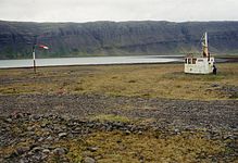
Landing runway with a trawler's bridge house as a "tower" in Vestfirðir (2002)

Peat farm in Dýrafjörður

Hrútafjörður

Hattardalur

Dýrafjörður fjord
Ósvör Maritime Museum in Bolungarvík

.JPG)


Individual evidence
Web links
- Official website (English / Icelandic)