
Bonnœuvre
| Bonnœuvre | ||
|---|---|---|
.svg)
|
|
|
| local community | Vallons-de-l'Erdre | |
| region | Pays de la Loire | |
| Department | Loire-Atlantique | |
| Arrondissement | Châteaubriant-Ancenis | |
| Coordinates | 47 ° 32 ′ N , 1 ° 14 ′ W | |
| Post Code | 44540 | |
| Former INSEE code | 44017 | |
| Incorporation | 1st January 2018 | |
| status | Commune déléguée | |

Bonnœuvre ( Breton : Banvre ; Gallo : Bonoevr ) is a town and commune Déléguée in the French community Vallons de l'Erdre with 558 inhabitants (as of January 1 2017) in the department of Loire-Atlantique in the Region Pays de la Loire . The inhabitants are called Bonnœuvriens .
On January 1, 2018, Bonnœuvre was merged with Freigné , Maumusson , Saint-Mars-la-Jaille , Saint-Sulpice-des-Landes and Vritz to form the municipality ( Commune nouvelle ) Vallons-de-l'Erdre. The common Bonnœuvre belonged to the Arrondissement of Châteaubriant-Ancenis and the Canton of Ancenis (until 2015: Canton Saint-Mars-la-Jaille ).
geography
Bonnœuvre is about 44 kilometers northeast of Nantes on the Erdre . Bonnœuvre is surrounded by the villages of Saint-Sulpice-des-Landes in the north, Saint-Mars-la-Jaille in the north and east, Maumusson in the southeast, Pannecé in the south and Riaillé in the west.
Population development
| year | 1962 | 1968 | 1975 | 1982 | 1990 | 1999 | 2006 | 2013 |
| Residents | 575 | 566 | 524 | 521 | 532 | 505 | 554 | 568 |
| Source: Cassini and INSEE | ||||||||
Attractions
- Saint-Martin church from 1863
- Former priory from the 12th century
- La Chèze mansion from the 15th century
- Watermill from 1820
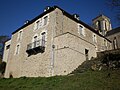
Former priory

Watermill


literature
- Le Patrimoine des Communes de la Loire-Atlantique . Flohic Editions, Volume 2, Charenton-le-Pont 1999, ISBN 2-84234-040-X , pp. 1125-1127.