
Freigné
| Freigné | ||
|---|---|---|
.svg)
|
|
|
| local community | Vallons-de-l'Erdre | |
| region | Pays de la Loire | |
| Department | Loire-Atlantique | |
| Arrondissement | Châteaubriant-Ancenis | |
| Coordinates | 47 ° 33 ′ N , 1 ° 7 ′ W | |
| Post Code | 49440 | |
| Former INSEE code | 49144 | |
| Incorporation | 1st January 2018 | |
| status | Commune déléguée | |

Freigné is a village and a commune déléguée in the French commune of Vallons-de-l'Erdre with 1,106 inhabitants (as of January 1, 2017) in the Loire-Atlantique department (until 2018: Maine-et-Loire department ) in the Pays region de la Loire . The inhabitants are called Freignéens .
On January 1, 2018, Freigné was merged with Bonnœuvre , Maumusson , Saint-Mars-la-Jaille , Saint-Sulpice-des-Landes and Vritz to form the municipality ( Commune nouvelle ) Vallons-de-l'Erdre. Vallons-de-l'Erdre belongs to the canton of Ancenis in the arrondissement of Châteaubriant-Ancenis . The municipality of Freigné belonged to the Arrondissement of Segré and the canton of Segré until January 1, 2018 (until 2015: Canton Candé ).
geography
Freigné is about 40 kilometers west-northwest of Angers and about 55 kilometers northeast of Nantes am Erdre .
Population development
| year | 1962 | 1968 | 1975 | 1982 | 1990 | 1999 | 2006 | 2013 |
| Residents | 1,528 | 1,415 | 1,187 | 1,118 | 1,017 | 985 | 1,119 | 1,131 |
| Source: Cassini and INSEE | ||||||||
Attractions
- Menhirs
- 19th century church Saint-Pierre
- Bourmont Castle from the 15th century
- Manor house La Grande-Maison (also manor house Ghaisne) from the 15th / 16th centuries century
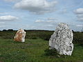
Menhirs

Bourmont Castle

Ghaisne manor house


Personalities
- Louis de Ghaisne (1773–1846), Marshal of France, Minister of War (1289/1830),
literature
- Le Patrimoine des Communes de Maine-et-Loire . Flohic Editions, Volume 1, Paris 2001, ISBN 2-84234-117-1 , pp. 360-361.