Brean Down

Brean Down is a headland off the coast of Somerset , England . It rises to 97 m (318 ft) and extends 2 km (1.5 mi) into the Bristol Channel at the east end of Bridgwater Bay between Weston-super-Mare and Burnham-on-Sea .
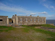
The elevation emerged from a limestone formation of the Dinantium and represents an extension of the Mendip Hills . If you continue the imaginary line, it is continued by the two islands of Steep Holm and Flat Holm . The cliffs on the north and south flanks of Brean Down are full of fossils from marine deposits dating from before 320-350 million. Years. The place has been inhabited by humans since the Bronze Age and there are remains of a Romano-Celtic temple. The Brean Down Fort , which was built in 1865 and expanded again during World War II , is facing the sea .
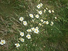
Brean Down is now owned by the National Trust for Places of Historic Interest or Natural Beauty . It is significant because it is home to a large number of protected animal and plant species and also because of its history and archaeological finds. It is designated as a Site of Special Scientific Interest . A particularly rare plant is the white rock rose (Helianthemum apenninum). It was also added to the list of Ancient Monuments .
geology
The Mendip Hills, the westernmost reaches of which are Brean Down and the two islands of Steep Holm and Flat Holm, form the southernmost mountainous formations of coal- bearing limestone in Britain . The deposits originated in the Mississippium , about 320-350 million years ago. Later in the Paleozoic , during the Variscan Orogeny, the originally horizontal plates unfolded and a complex system of mountains and ridges developed in Ireland and south-western England and in other regions of Europe. The Mendip area consists of at least four anticlinic folds , most of which run in an east-west direction, each characterized by a core of older Devonian sandstones and Silurian volcanic rocks. To the west of the main Mendip plateau, the formation continues in Bleadon Hill and Brean Down, as well as the islands mentioned above.
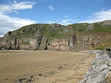
Brean Down is approximately 2 km (1.2 mi) long and runs in an east-west direction near the mouth of the River Ax across from Uphill Cliff . The elevation rises to 97 m above sea level . The cliffs in the north and south contain rich fossil deposits of corals, mussel shells and sea lilies . 13 distinguishable layers have been identified in the sand cliff on the south side.
history
Human settlement goes back to the time of the bell beaker culture . There is also evidence of an Iron Age hill fort and prehistoric barrows . There was already a place of worship in pre-Roman times, which was revived as the Romano-Celtic Temple in the middle of the 4th century. A Christian chapel (oratory) possibly followed later. Finds from Roman times include coins from Augustus , Nero and Drusus , two silver denarii from Vespasian and a carnelian .
Brean Down Fort was built on the headland between 1864 and 1871. The Royal Commission on the Defense of the United Kingdom in 1859 had recommended building a number of Palmerston forts as a line of defense on the Bristol Channel to protect Bristol and Cardiff from attack. To this end, four acres of land on Brean Down were requisitioned in 1862. Construction began in 1864 and was completed in 1871.
In the 1860s plans were made for a deep water port on the north coast. Originally, this port was supposed to replace Bristol as the embarkation port for transatlantic crossings and the export of raw materials and agricultural products from the Mendip Hills and Somerset. The foundations for the pier were laid, but a strong storm destroyed the foundations and the plan was again dropped. In 1897 Guglielmo Marconi set a new distance record for radiotelegraphy over the open sea when he made transmissions from Lavernock Point in Wales, and in 1912 Brean Down was leased as a bird sanctuary by the Royal Society for the Protection of Birds .
At the outbreak of World War II, the fort was armed with two 6-inch (15 cm) ex-naval guns and machine gun posts were set up on the Down . Birnbeck Pier was used by the Admiralty in 1941 as an outpost of the Department of Miscellaneous Weapons Development (DMWD). It was commissioned as HMS Birnbeck and was used for the secret storage and testing of weapons. The " bouncing bomb " was tested at Brean Down Fort on the opposite side of Weston Bay.
In 1954, the then Axbridge Rural District Council donated 59,685 hectares (147,480 acres) of Downaus to the National Trust for the Festival of Britain . The Major Aldermen and Burgesses of the Borough of Weston-Super Mare donated an additional 1,494 hectares (3,690 acres) in 1963 and an additional 1,371 hectares (3,390 acres) at Brean Down Cove were acquired by MD and M. Matthews in 2000. After the restoration of the 1,606 hectare (3,970 acres) fort, the Sedgemoor District Council gave it to the National Trust in 2002.
There were various plans for the construction of a Severn Barrage to generate electricity from tidal power. So far, the proposals had not found support, but there are always activists who advertise such a power plant.
ecology

In addition to the geological features, the vegetation in particular led to the classification as a Site of Special Scientific Interest . The rare white rock rose ( Helianthemum appenninum , Apennine sun rose) is common. There are some broomrapes (summer herbs), which are probably not "Oxtongue broomrape" ( Orobanche artemisiae-campestriae ), as originally thought , but rather specimens of the Ivy broomrape ( Orobanche hederae ). Other characteristic plants are Somerset hair grass , sand thyme (Thymus serpyllum), common horseshoe clover ( Hippocrepis comosa, horseshoe vetch) and horn clover (lotus, birds-foot-trefoil), which grow mainly on the southern slopes. The north side is characterized by Adler ferns (bracken), blackberry (bramble), privet (privet), Crataegus monogyna (Crataegus monogyna, hawthorn), Cowslip (Primula Veris, cowslip) and Erica cinerea (Erica cinerea, bell heather).
The bird world includes peregrine falcon , jackdaw , kestrel , turkish dove and stock dove , blackcap , bloodline , meadow treacher , dunnock , beach pipit and - in 2007 - the first and only yellow-nosed albatross in Britain. are remarkable also some types of butterflies: Chalkhill Blue (Chalkhill blue), dark green fritillary (dark green fritillary), Meadow Brown (meadow brown), checkerboard (Butterfly) (Melanargia galathea, marbled white), Small Heath (Small Heath) and Common Blue .
Individual evidence
- ↑ Multi-period site on Brean Down . English Heritage. Archived from the original on May 2, 2014. Retrieved June 7, 2014.
- ↑ Faulkner 1989. pp. 93-106
- ^ GCR block - Variscan Structures of South-West England . Joint Nature Conservation Committee. Retrieved March 5, 2010.
- ↑ Kellaway, Welch, 1948. pp. 7, 10-11, 16 & 34-38
- ↑ Haslett 2010. pp. 25-28
- ↑ Coysh, Mason, Waite 1977. p. 67
- ^ Hugh Prudden: Somerset Geology - a good rock guide (PDF) Bath Geological Society. Retrieved February 6, 2014.
- ↑ Haslett 2010. pp. 128-132.
- ↑ Atthill 1976. pp. 52-53
- ↑ Goldberg 2009. pp. 43-46
- ↑ Adkins 1992. pp. 27-29; Quinn 2008. pp. 21-22
- ↑ ApSimon 1958. pp. 106-109; ApSimon 1965. pp. 195-258
- ↑ Aston, Burrow 1991; Atthill 1976. pp. 72-73
- ↑ Hillfort, Brean Down . In: Somerset Historic Environment Record . Somerset County Council . Archived from the original on August 7, 2011. Retrieved July 7, 2011.
- ^ Victorian artillery battery, Brean Down . In: Somerset Historic Environment Record . Somerset County Council. Archived from the original on May 19, 2011. Retrieved May 6, 2008.
- ^ Chris Newton: Exploring the Secrets of Brean Down, Western extremeties of the Mendips on the River Ax Estuary . In: Somerset Life , January 27, 2010. Retrieved March 2, 2014.
- ↑ Brean Down . In: Western Daily Press , British Newspaper Archive, October 6, 1862. Retrieved July 7, 2014.
- ↑ Dunning 2003. p. 116
- ^ Marconi: Radio Pioneer . In: BBC South East Wales . Retrieved April 12, 2008. Marconi at Brean Down (near Bristol) . International Marconi Day. Archived from the original on February 19, 2014. Retrieved February 6, 2014 .; Garratt 1994. p. 86.
- ↑ Brean Down . In: Gloucester Journal , British Newspaper Archive, September 14, 1912. Retrieved July 7, 2014.
- ↑ van der Bijl 2000. pp. 119-123
- ↑ Birnbeck Pier . In: The Heritage Trail . Archived from the original on February 18, 2010. Retrieved April 18, 2010.
- ↑ Experimental weapon rails, Brean Down . In: Somerset Historic Environment Record . Somerset County Council. Archived from the original on May 19, 2011. Retrieved May 6, 2008 .; Evans 2004. pp. 5-11.
- ↑ a b c Acquisitions Up to December 2011 . National Trust. Archived from the original on July 14, 2014. Retrieved on February 6, 2014.
- ^ Gerry Brooke: Back to the drawing board . In: Western Daily Press . This is Bristol. August 4, 2008. Archived from the original on May 3, 2012. Retrieved on December 12, 2009.
- ^ Clare Hutchinson: 'Real cost' of Severn Barrage £ 34bn . In: WalesOnline , October 19, 2010. Retrieved September 18, 2012.
- ↑ Bethan Evans: Barrage bid to be looked at - again . In: The Weston & Somerset Mercury , September 9, 2012. Retrieved July 12, 2014.
- ↑ a b Brean Down (PDF) In: English Nature . Retrieved March 2, 2014.
- ^ Twist 2001.
- ↑ Green, Green, Crouch, 1997.
- ^ 1st Sighting of a Molly in Britain - A Mega Event for Twitchers . Tristan da Cunha. Archived from the original on April 21, 2012. Retrieved February 6, 2014.
- ↑ Brean Down Butterflies . Brean Down Fort. Archived from the original on December 17, 2013. Retrieved March 2, 2014.
literature
- Lesley and Roy Adkins: A field Guide to Somerset Archeology . Dovecote press, Stanbridge 1992, ISBN 0-946159-94-7 .
- AM ApSimon: The Roman temple on Brean Down, Somerset: An Interim Report on the 1957 Excavations . (PDF) In: UBSS Proceedings . 8, No. 2, 1958, pp. 106-109.
- AM ApSimon: The Roman Temple on Brean Down, Somerset . (PDF) In: UBSS Proceedings . 10, No. 3, 1965, pp. 195-258.
- Mick Aston, Ian Burrow: The Archeology of Somerset . Somerset County Council, Taunton 1991, ISBN 978-0-86183-028-2 .
- Robin Atthill: Mendip: A New Study . David & Charles, 1976, ISBN 978-0-7153-7297-5 .
- Martin Bell: Brean Down: Excavations 1983-1987 (= Archaeological Report. Number 15). Historic Buildings and Monuments Commission for England, London 1990, ISBN 1-850-74268-5 ( digitized ).
- AW Coysh, EJ Mason, V. Waite: The Mendips . Robert Hale Ltd, London 1977, ISBN 0-7091-6426-2 .
- Robert Dunning: A History of Somerset . Somerset Books, Tiverton 2003, ISBN 0-86183-476-3 .
- Roger Evans: Somerset tales of mystery and murder . Countryside Books, Newbury 2004, ISBN 978-1-85306-863-8 .
- TJ Faulkner: The early Carboniferous (Courceyan) Middle Hope volcanics of Weston-super-Mare: development and demise of an offshore volcanic high . In: Proceedings of the Geologists' Association . 100, No. 1, 1989, pp. 93-106. doi : 10.1016 / S0016-7878 (89) 80068-9 .
- GRM Garratt: The Early History of Radio: From Faraday to Marconi . IET, 1994, ISBN 978-0-85296-845-1 .
- Paul Goldberg: Practical and Theoretical Geoarchaeology . John Wiley & Sons, 2009, ISBN 978-1-4443-1225-6 .
- Paul R. Green, Ian P. Green, Geraldine R. Crouch: The Atlas Flora of Somerset . PR Green, IP Green, and GA Crouch, 1997, ISBN 978-0-9531324-0-9 .
- Simon K. Haslett: Somerset Landscapes: Geology and Landforms . Blackbarn Books, Usk 2010, ISBN 978-1-4564-1631-7 .
- GA Kellaway, FBA Welch: Bristol and Gloucester District (= British Regional Geology), Second. Edition, HMSO for Natural Environment Research Council, Institute of Geological Sciences, Geographical Survey and Museum, London 1948, ISBN 0-11-880064-7 .
- Tom Quinn: Hidden Britain . New Holland Publishers, 2008, ISBN 978-1-84773-129-6 .
- Colin Twist: Rare Plants in Great Britain - a site guide . Colin Twist, 2001.
- Nicholas van der Bijl: Brean Down Fort: Its History and the Defenses of the Bristol Channel . Hawk Editions, Cossington 2000, ISBN 978-0-9529081-7-3 .
Web links
Coordinates: 51 ° 19 '32.2 " N , 3 ° 1' 44.4" W.


