Breetze
|
Breetze
City of Bleckede
Coordinates: 53 ° 15 ′ 52 ″ N , 10 ° 42 ′ 30 ″ E
|
||
|---|---|---|
| Residents : | 214 (Nov 16, 2004) | |
| Incorporation : | March 1, 1974 | |
| Postal code : | 21354 | |
| Area code : | 05852 | |
|
Location of Breetze in Lower Saxony |
||
Breetze ( Low German Breitz ) is a rural part of the Lower Saxon town of Bleckede in the Lüneburg district with 214 inhabitants (as of November 16, 2004).
geography
Breetze is about 90 m above sea level on a ridge within the Breetzer Mountains , where the Telegraphenberg is not far from Breetze. The Breetz Mountains are counted among the terminal moraines . Geographically, Breetze is roughly halfway between the villages of Neu Süttorf, Nindorf, Ellringen and the main town of Bleckede.
Breetze is divided into an upper and a lower village. The lower village lies in the direction of Bleckede at the foot of the Geest and is often referred to as the "brickworks". It was named after a brickyard (which has since been demolished) . Breetze has a volunteer fire brigade (90 members) and a restaurant "Zurmühlen". Otherwise there are no other public institutions or companies; except for some private pensions.
history
The census of September 13, 1950 showed that there were 293 residents in 84 households. On March 1, 1974 Breetze was incorporated into the city of Bleckede.
Attractions

Telegraphenberg
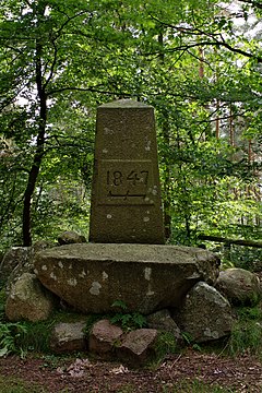
At the beginning of the 19th century, the name of the mountain was different according to its use at the time: the excrement left behind by the cattle, which the farmers grazed in the heather and forest areas, gave the mountain the name "Köttelberg". The current name still refers to a use, but to a different one, which took place only a little later: During the Russian campaign of Napoleon I (1812), an optical telegraphy station was located on the mountain that led to Paris . Remnants of this station are no longer present on the mountain, so that only the name Telegraphenberg reminds of it. The current shape of the mountain is no longer based on the French era , but is connected to the so-called Ernst-August-Rex stone . The nearly head-high obelisk made of granite adorned on its south side, the royal crown and including the letter "EAR" meaning: E : Ernst , A : August , and R : Rex (= lat. King ). The stone, together with the year “1847” on the north side of the stone, refers to Ernst August I (King of Hanover, Duke of Braunschweig-Lüneburg from 1837–1851). The wolf tang, which can also be seen on the north side of the stone - a symbol of domination in the forestry context - illustrates the broader context of the stone setting: "The establishment of the state forests in connection with the coupling , the replacement of the obligations on the farms and the rights to graze ". Erich Hessing explains that after the coupling in 1838, the farmers began to cancel the obligations on the farms by paying “twenty-five times the annual tax”. For this purpose, they sold their heather areas in the Breetz mountains to the “Royal Domain Treasury” in 1847; the state forest administration soon started to reforest the area. In the same year, after the acquisition of 3 farms in Bargmoor (about 2.5 km south-southeast of Telegraphenberg) by the tax authorities, the farms were merged into a forester's office . The memorial on the Telegraphenberg is therefore "nothing more than the documentation of an occupation and brings a piece of Breetze's village history to life". After 1945, a 16 m high fire watch tower was erected on the mountain top , but it was demolished in the late 1970s and early 1980s due to its dilapidation . Next to the monument there are four heavy " foundation stones ".
Individual evidence
- ↑ Günther Wagener: Directory of the cities, integrated communities, the member communities and districts in the Hanseatic city and the district of Lüneburg with the entry of the Low German place names. (pdf) In: www.landkreis-lueneburg.de. August 27, 2015, p. 2 , accessed December 20, 2018 .
- ^ Federal Statistical Office (ed.): Official municipality directory for the Federal Republic of Germany. Final results after the census of September 13, 1950 (= Statistics of the Federal Republic of Germany . Volume 33 ). W. Kohlhammer, Stuttgart / Cologne 1952, p. 45 ( digital version [PDF; 27.1 MB ]).
- ^ Federal Statistical Office (ed.): Historical municipality directory for the Federal Republic of Germany. Name, border and key number changes in municipalities, counties and administrative districts from May 27, 1970 to December 31, 1982 . W. Kohlhammer, Stuttgart / Mainz 1983, ISBN 3-17-003263-1 , p. 234 .
- ↑ a b c d Erich Hessing : Monuments, people and stories in the Lüneburg district . Ed .: District of Lüneburg. Stern-Verlag, Lüneburg 1981, p. 43 .
- ↑ a b Erich Hessing: Monuments, people and stories in the Lüneburg district . Ed .: District of Lüneburg. Stern-Verlag, Lüneburg 1981, p. 44 .
- ↑ a b Ulf Amelung: Around Lüneburg. Small hiking guide and local excursion guide for the Lüneburg district . Edmund Hahn printing house, Lüneburg 1986, p. 135 .


