Brossen
|
Brossen
City of Meuselwitz
Coordinates: 51 ° 2 ′ 32 " N , 12 ° 15 ′ 54" E
|
||
|---|---|---|
| Height : | 180 m above sea level NN | |
| Residents : | 270 | |
| Incorporation : | July 1, 1950 | |
| Incorporated into: | Zipsendorf | |
| Postal code : | 04610 | |
| Area code : | 03448 | |
|
Location of Brossen in Thuringia |
||
|
In the town
|
||
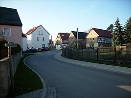
Brossen is a district of Meuselwitz in the Altenburger Land district in Thuringia .
Location and traffic
Brossen is located three kilometers west of Meuselwitz on the federal highway 180 in the Altenburg-Zeitz loess hill country . The state border with Saxony-Anhalt runs in the west of the district. Further to the west is the Sprossen airfield and the water-filled residual hole of the Zipsendorf opencast mine . Brossen does not border on Saxony, however, the triangle is located in the north on the edge of Prößdorf .
The demarcation is docked. Green erosion channels loosen up the landscape.
history
The village was first mentioned on April 26, 1296. Brossen is one of the few places in today's Altenburger Land district that historically did not belong to Saxony-Altenburg . Together with today belonging also to Thuringia Meuselwitz places Zipsendorf , Falkenhain and Rusendorf was Brossen to 1815 in the office Zeitz , which as part of the Bishopric of Naumburg-Zeitz since 1561 under electoral Saxon stood sovereignty and between 1656/57 and 1718 for Sekundogenitur -Fürstentum Saxe-Zeitz belonged to. Due to the resolutions of the Congress of Vienna , the place came to Prussia in 1815 and was assigned to the Zeitz district in the administrative district of Merseburg of the province of Saxony in 1816.
Since the second half of the 19th century, lignite mining around the place was of increasing importance. Brossen was in the Prussian western part of the Meuselwitz-Altenburg lignite mining area . In the east and north of the place between 1931 and 1939/40 the open- cast brown coal mine "Schädegrube II" extended. West of Brossen, the Zipsendorf-Süd opencast mine was in operation between 1948 and 1964 .
Brossen, which came to the newly founded state of Saxony-Anhalt in 1947 with the former Prussian district of Zeitz , was incorporated into Zipsendorf on July 1, 1950. With the territorial reform in the GDR in 1952 , Zipsendorf and its Brossen district were assigned to the newly cut Zeitz district in the Halle district . On December 4, 1952, the communities of Zipsendorf with Brossen, Falkenhain with the corridor of Rusendorf and Mumsdorf, which only came to the Zeitz district in 1950, were reclassified to the Altenburg district in the Leipzig district .
On January 1, 1973, Zipsendorf and Brossen became districts of Meuselwitz through incorporation. With the re-establishment of the Free State of Thuringia Brossen came as a district of Meuselwitz to the Thuringian district of Altenburg, which merged in 1994 to form the district of Altenburger Land.
Events
The Brossen village festival takes place annually on the first weekend in August.
Personalities
- Rudolf Brazda (1913–2011), survivor of Buchenwald concentration camp , the last living gay concentration camp inmate before his death
Individual evidence
- ^ Wolfgang Kahl: First mention of Thuringian towns and villages. A manual. Rockstuhl Verlag, Bad Langensalza 2010, ISBN 978-3-86777-202-0 , p. 42.
- ^ Karlheinz Blaschke , Uwe Ulrich Jäschke : Kursächsischer Ämteratlas , Leipzig 2009, ISBN 978-3-937386-14-0 , p. 86 f.
- ^ The Zeitz district in the municipal directory 1900
- ↑ The Altenburg / Meuselwitz lignite district, LMBV publication
- ↑ [1]
- ^ Zipsendorf on gov.genealogy.net
Web links


