Bunger Hills
| Bunger Hills | ||
|---|---|---|
|
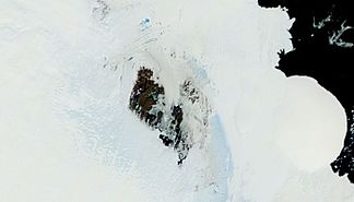
MODIS satellite image of the Bunger Hills |
||
| location | Wilkesland , East Antarctica | |
|
|
||
| Coordinates | 66 ° 17 ′ S , 100 ° 47 ′ E | |
The Bunger Hills are a group of relatively flat and moraine superimposed hill with rounded crests, that of the ice-free in the summer months south High Jump archipelago directly on the Knoxküste the East Antarctic Wilke Lands lie. They are characterized by numerous meltwater pools and are almost halved by Algae Lake in an east-west direction. The hills are part of the bungy oasis .
They were mapped using aerial photographs taken during Operation Highjump (1946–1947) under the direction of the US polar explorer Richard Evelyn Byrd . The Advisory Committee on Antarctic Names named them after Lieutenant Commander David Eli Bunger (1909–1971) of the United States Navy , who was involved in the making of said aerial photographs in Operation Highjump as an aircraft commander and in February 1947 on one of the non-frozen lakes in dared a splash in the hills .
geology
The Bunger Hills are combined with the Obruchev Hills to the southwest and the Highjump Archipelago to the northeast to form a geologically related unit. It extends about 150 kilometers northeast of Cape Jones , which is on the eastern edge of Denman Glacier . The actual Bunger Hills emerge in an area of around 300 square kilometers.
They consist mainly of Felsic orthogneiss with an overprinting metamorphic to granulite facies as well as subordinate mafic granulites and paragneiss . The latter are made up of quartzites and aluminous metapelites with significant proportions of garnets , sillimanites and cordierites, as well as insignificant calcium silicate rocks and marbles . The igneous protoliths (parent rocks) of the granodioritic orthogneiss took place between 1,700 and 1,500 mya. The oldest rocks are neo-archaic 2,640 mya old tonalitic orthogneiss that occur in the southwestern Obruchev Hills . The strongest metamorphosis occurred before 1,190 mya and the first was accompanied by three deformations.
Between 1,170 and 1,150 mya, voluminous plutonites , mainly derived from the Earth's mantle , intruded . Their rock spectrum ranges from gabbros to diorite to granite , each with different mineral components. The penetration of numerous dolerite dykes from four chemically separated rows occurred around 1,140 mya. This was associated with the formation of shear zones , suggesting at least limited crust elevation. All subsequent deformations were brittle to ductile. Alkaline mafic dykes intruded 500 mya before.
Clear geochronological similarities with the Albany-Fraser Orogen in Western Australia suggest that a high-grade metamorphosis occurred during the collision between the Australian Yilgarn Craton and the East Antarctic Shield about 1,200 mya (see also → Albany Fraser Orogen ). During this period Rodinias formed and correlated roughly with the Grenville orogeny .
Another hypothesis is that the Bunger Hills area formed as a volcanic island arc with an active continental margin and then collided with Western Australia.
The tectono-magmatic events around 500 mya could have their cause in the merging of East Gondwana and / or the long-range action of the Ross orrogens .
Individual evidence
- ↑ JW Sheraton, RJ Tingey, RL Oliver and LP Black: Geology of the Bunger Hills-Denman Glacier region, East Antarctica. In: Australian Geological Survey Organization, Department of Primary Industries and Energy, Bulletin 244. PDF
- ^ MH Monroe: Yilgarn Craton, Western Australia. In: Australia: The Land Where Time Began, A biography of the Australian continent. Online article
- ↑ CV Spaggiari, C. L Kirkland, MJ Pawley, RH Smithies, MTD Wingate, MG Doyle and others: The geology of the east Albany – Fraser Orogen - a field guide. In: Government of Western Australia, Department of Mines and Petroleum, Record 2011/23, 97 p. Online article
Web links
- Bunger Hills in the Geographic Names Information System of the United States Geological Survey (English)
- Bunger Hills on geographic.org (English).

