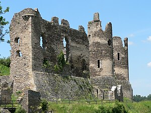
Rocher Castle
| Rocher Castle | |
|---|---|
|
The castle ruins from the southeast |
|
| Creation time : | 13th Century |
| Castle type : | Hilltop castle |
| Conservation status: | ruin |
| Place: | Saint-Rémy-de-Blot |
| Geographical location | 46 ° 5 '22 " N , 2 ° 55' 41" E |
The ruins of Rocher Castle , known in French as Château Rocher or Château de Blot-le-Rocher , are the ruins of a hilltop castle in the French Auvergne in the municipality of Saint-Rémy-de-Blot . Since January 20, 1913 is available as a monument historique under monument protection .
The castle was built by the Bourbons in the 13th century to protect the Menat Bridge , the only river crossing between Ébreuil and Châteauneuf-les-Bains . Abandoned in the 18th century, it fell into ruin. This towers over the Sioule valley and can be reached from Menat via a hiking trail.
Web links
Commons : Burg Rocher - Collection of images, videos and audio files
- Homepage of the friends' association
- Rocher Castle in the Base Mérimée of the French Ministry of Culture (French)
- Photos of the ruin
- Photos from Base Mémoire
- Rocher Castle on richesheures.net (French)
- Video of the castle complex on Wehrbauten.de
Individual evidence
- ↑ Brief information on the castle ruins , as of January 19, 2009.

