Candida (Campania)
| Candida | ||
|---|---|---|

|
|
|
| Country | Italy | |
| region | Campania | |
| province | Avellino (AV) | |
| Coordinates | 40 ° 57 ' N , 14 ° 53' E | |
| height | 579 m slm | |
| surface | 5.43 km² | |
| Residents | 1,105 (Dec 31, 2019) | |
| Population density | 203 inhabitants / km² | |
| Post Code | 83040 | |
| prefix | 0825 | |
| ISTAT number | 064016 | |
| Popular name | Candidesi | |
| Patron saint | San Filippo Neri | |
| Website | Candida | |
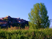
Candida is an Italian commune with 1105 inhabitants (as of December 31, 2019) in the province of Avellino in the Campania region . The municipality is economically shaped by agriculture.
geography
The place is located on a hill about 580 m above sea level. The distance to the southwestern provincial capital Avellino is about ten kilometers, Naples is about 70 km to the west.
The neighboring municipalities are Lapio , Manocalzati , Montefalcione , Parolise , Pratola Serra and San Potito Ultra .
history
Archaeological finds show that as early as the 4th century BC BC people must have lived in the area of the church. The first written mention comes from 1045 when it came under the sovereignty of Avellino during the rule of the Lombards.
Web links
Commons : Candida (Campania) - Collection of images, videos and audio files
Individual evidence
- ↑ Statistiche demografiche ISTAT. Monthly population statistics of the Istituto Nazionale di Statistica , as of December 31 of 2019.


