
Arrecife
| Arrecife municipality | |||
|---|---|---|---|
 Aerial photo 2011, looking northeast
|
|||
| coat of arms | Map of the Canary Islands | ||

|
|
||
| Basic data | |||
| Autonomous Community : | Canary Islands | ||
| Province : | Las Palmas | ||
| Island: | Lanzarote | ||
| Coordinates | 28 ° 58 ′ N , 13 ° 33 ′ W | ||
| Height : | 30 msnm | ||
| Area : | 22.72 km² | ||
| Residents : | 62,988 (Jan 1, 2019) | ||
| Population density : | 2,772.36 inhabitants / km² | ||
| Postal code : | E-35500 | ||
| Municipality number ( INE ): | 35004 | ||
| administration | |||
| Mayor : | Manuel Fajardo Feo ( CC ) (2014) | ||
| Address of the municipal administration: | Avda. de Vargas, 1 35500 - Arrecife |
||
| Website : | www.arrecife.es | ||
| Location of the municipality | |||

|
|||

Arrecife is the since 1852 capital of about Spain belonging Canary Island of Lanzarote . The old capital was previously Teguise inland. Arrecife also forms one of the seven municipalities of the island and with 62,988 inhabitants (January 1, 2019) is home to almost half of all Lanzaroteños.
character
The cityscape of Arrecifes is shaped by its residents, tourists play a subordinate role here. The city center with the town hall and the pedestrian street Calle de Leon y Castillo borders the Atlantic Ocean with the promenade. From there, a drawbridge leads to the fortress Castillo de San Gabriel, which is located on an island and dates back to the 16th century. On the coast to the south follows the tallest building on the island, the Gran Hotel , which was completed in the late 1960s , but which was closed in 1991 for economic reasons and burned out in 1994. In July 2004 it was reopened after being rebuilt. Further south follows the beach of Playa del Reducto , the bus station and the Cabildo Insular de Lanzarote , the building of the island's government. North of the city center is the Charco de San Ginés , the tidal lagoon that extends into the urban area. This is where the beginnings of Arrecife lie. Further north on the coast are the fishing port of Puerto de Naos , the fortress Castillo de San José from the 18th century and the commercial port of Los Mármoles, which is important for the entire island . To the north of this is the seawater desalination plant built in 1964 for the entire island, which is still in operation today.
Arrecife is made up of the following districts:
Arrecife Centro, Argana Alta, Argana Baja, El Cable, La Concha, Maneje, Los Alonso, Altavista, Parque Maneje, Las Salinas, San Francisco Javier, Tenorio, Titerroy, Valterra, La Vega, Puerto Naos, Punta Grande.
In 1974, César Manrique opened the El Almacén multi-purpose cultural center to promote culture in the island's capital. It should be a meeting place for artists of all nationalities. The first opportunity to exhibit was offered in the El Aljibe art gallery on the island of Lanzarote. El Almacén also includes the Pablo Ruíz Picásso restaurant, named after Manrique's friend, and later a cinema. In 1989 the island government acquired the loss-making center and placed a cultural department there.
The football club Unión Deportiva Lanzarote is based in the Arrecifer stadium Ciudad Deportiva de Lanzarote and currently plays in the third highest division. The 7,000-seat stadium was inaugurated in 1968. The previous stadium was called Avendaño Porrúa .
The Brazilian city of Recife has been a twin town since 2010 .
traffic
About five kilometers south of Arrecife is the Lanzarote international airport , which is already in the neighboring community of San Bartolomé . Charter and scheduled flights from all over Europe and regional flights to the other Canary Islands are handled here.
Arrecife owns the Los Mármoles seaport, which is important for Lanzarote . It is a transshipment point for important goods on the island. There are also some ferries from here to the neighboring islands of Tenerife , Gran Canaria and Fuerteventura as well as to Cádiz on the Spanish mainland. Cruise ships dock here or at Puerto de Naos, which is closer to town .
Public buses, known as guaguas , run from a bus station south of the promenade to several places on the island.
Picture gallery
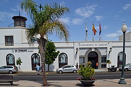
town hall
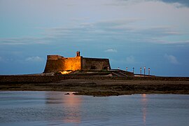
Castillo de San Gabriel
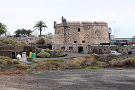
Castillo de San José

Iglesia de San Gines

The Charco de San Ginés lagoon

Gran Hotel Arrecife

Waterfront

Pedestrian street, Calle de Leon y Castillo

Buildings of the Cabildo Insular de Lanzarote


history
Arrecife was first mentioned in the 15th century as a small fishing village. The city owes its name to the Arrecifes , the black volcanic reefs behind which boats could hide to protect themselves from pirate attacks.
Towards the end of the 16th century, Arrecife began to grow, as it had become necessary to build houses and warehouses for the dockworkers and employees for trade between the Old and New World (America). As a result, the place became a sought-after pirate destination. In 1571 the pirate Dogan plundered and almost completely destroyed the port town.
A few years later, work began on the Castillo de San Gabriel on the offshore, small island of Islote de Fermina , which was expected to provide a high level of protection against pirate attacks. But as early as 1586 the pirate Morato Arraez landed in the city, practically put an end to it and in the process destroyed the first fortress, which was built in 1574. Today's Castillo de San Gabriel , with its bell tower and sentry box, was built around 1590 by order of the Spanish King Philip II and according to plans by Leonardo Torriani . The Castillo de San Gabriel is now the Museo Arqueológico y Etnográfico Castillio de San Gabriel , in which finds from the time before 1402 are shown, when the island was not yet integrated into the Castilian culture. A landmark of Arrecife is the drawbridge Puente de las Bolas , which connects Arrecife with the Castillo.
A little to the north, it is located in 1776 at the instigation of King Karl III. built Castillo de San José . It is located on the peninsula, the Cueva de Inés , eight meters above the steep coast , and is also called Hungerburg by the locals , as the population suffered from hunger after the massive volcanic eruptions on the island in the middle of the 18th century. The construction was designed by the civil engineer Alfonso Ochando to provide work and protection from pirate attacks . Since these no longer took place, the Hungerburg lost its importance. In 1974 the Castillo de San José was converted into the Museum of Contemporary Art ( Museo Internacional de Arte Contemporáneo ) by the artist and environmentalist César Manrique . This includes a restaurant with a panoramic view of the sea and a newly formed hall for concerts and conferences. The gallery houses paintings by Spanish artists. Works by Joan Miró and Manolo Millares , Óscar Domínguez and Gerardo Rueda , Eusebio Sempérez , Augustín Cárdena and Manrique himself can be seen, among others .
In 1792 the Muelle de las Cebollas (the pier of the onions) was built as part of the new port. It granted protection from the waves of the Atlantic and served as a pier for the ships.
San Ginés Church
,_Arrecife,_Lanzarote.jpg)
In 1574 the first church in Arrecife was built and consecrated to Saint Genesius, Bishop of Clermont (San Ginés). After being completely flooded, it had to be rebuilt in 1665. On the occasion of the opening of the port on June 25, 1798, the first mass was held in the church, which had been declared an independent parish . At the beginning of the 19th century two naves were added one after the other and the church tower was the last to be built in 1842. With its three-aisled interior and carved wood ceiling, the Iglesia de San Ginés in the Plaza de las Palmas is the oldest church on Lanzarote.
Population development
Demographic evolution of the population of Arrecife since 1842:

- Source: INE
sons and daughters of the town
- César Manrique (1919–1992), artist, architect, sculptor and environmentalist
- Goya Toledo (* 1969), actress and photo model
- Rosana (* 1963), singer
literature
- Antonio Jesús Montelongo Franquiz, Marcial Alexis Palero Lemes: El Puerto del Arrecife . Cabildo de Lanzarote y Ayuntamiento de Arrecife, Arrecife 2000, ISBN 84-87021-75-1 , p. 414 (Spanish, ulpgc.es [accessed December 14, 2017]).
- José Manuel Clar Fernández: La Iglesia de San Ginés en el Puerto del Arrecife . Ed .: M. Carmen Otero Alonso. Centro de la Cultura Popular Canaria, Gran Canaria 2002, ISBN 84-7926-417-9 (Spanish, ulpgc.es [accessed September 20, 2018]).
Web links
Individual evidence
- ↑ Cifras oficiales de población resultantes de la revisión del Padrón municipal a 1 de enero . Population statistics from the Instituto Nacional de Estadística (population update).
- ↑ Fernando Gabriel Martín Rodríguez: La primera imagen de Canarias / Los dibujos de Leonardo Torriani . Colegio Oficial de Arquitectos de Canarias (COAC), Santa Cruz de Tenerife 1986, ISBN 84-600-4660-5 , p. 63 (Spanish, ulpgc.es [accessed December 13, 2017]).
- ↑ a b c Trilingual information board on the church square
- ↑ Municipio: 35004 Arrecife . Alteraciones de los municipios en los Censos de Población desde 1842, INEbase. Cuando se dispone del dato de población de hecho y de derecho se ha tomado la cifra más alta. Consultado el 15 de noviembre de 2013.