Chickasaw, Alabama
| Chickasaw | |
|---|---|
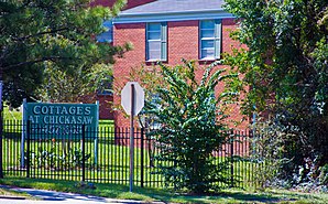
 Chickasaw Shipyard Village Historic District (2012) |
|
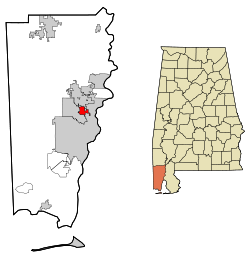
| Location in County and Alabama | |
| Basic data | |
| Foundation : | 1946 |
| State : | United States |
| State : | Alabama |
| County : | Mobile County |
| Coordinates : | 30 ° 46 ′ N , 88 ° 5 ′ W |
| Time zone : | Central ( UTC − 6 / −5 ) |
| Residents : | 6,106 (as of 2010) |
| Population density : | 531 inhabitants per km 2 |
| Area : | 11.9 km 2 (approx. 5 mi 2 ) of which 11.5 km 2 (approx. 4 mi 2 ) is land |
| Height : | 162 m |
| Postcodes : | 36611, 36671 |
| Area code : | +1 251 |
| FIPS : | 01-14392 |
| GNIS ID : | 0116030 |
| Website : | www.cityofchickasaw.org |
Chickasaw is a city in Mobile County in the state of Alabama in the United States . In 2010 about 6100 people lived here.
geography
Chickasaw is located in southwest Alabama in the southern United States. The city is about 30 kilometers east of the Mississippi border and 9 kilometers north of Mobile Bay . It is also less than a kilometer west of the Mobile River , which flows a few kilometers south into Mobile Bay and the Gulf of Mexico .
Nearby places include Saraland (immediately to the north), Prichard (immediately to the west and south), Mobile (immediately to the east), Satsuma (5 km north) and Kushla (6 km north-west).
history
The city was founded as a workers' settlement in the 1920s . The name was chosen in memory of a tribe of Muskogee Indians who lived in the area. A post office was founded in 1924, and the incorporation followed in 1946.
One site in Chickasaw is listed on the National Register of Historic Places (as of December 11, 2019), the Chickasaw Shipyard Village Historic District .
traffic
To the west of the city is Interstate 65 , which runs 1,436 kilometers from Alabama to Indiana . US Highway 43 runs roughly through the center of the city . There is a connection to US Highway 45 2 kilometers southwest, and US Highway 98 6 kilometers southwest . Interstate 10 also runs 7 kilometers south of the city .
Mobile Regional Airport is located around 16 kilometers to the southwest .
To the east of the city is the port of Chickasaw.
Demographics
The 2000 census showed a population of 6,364, divided into 2,747 households and 1,747 families. The population density was 555 people per square kilometer. 88.9% of the population were white, 8.1% black, 1.4% American Indians and 0.2% Asian. 0.3% were of a different ethnicity , 1.1% had two or more ethnicities, and 1.2% were Hispanics or Latin Americans of any ethnicity. For every 100 women there were 86 men. The median age was 39 years and the per capita income was 14,190 US dollars, which put about 17.1% of the population below the poverty line.
By the 2010 census , the population had dropped to 6,106.
sons and daughters of the town
- Ray Sawyer (1937-2018), musician (Dr. Hook & the Medicine Show)
Web links
- Official website of the city (Engl.)
- Chickasaw in the Encyclopedia of Alabama (Engl.)
- Statistical data on Chickasaw (Engl.)
Individual evidence
- ↑ Place Names in Alabama , University of Alabama Press, Tuscaloosa 1989, p. 32 ( on Google Books )
-
↑ Search mask database in the National Register Information System. National Park Service , accessed December 11, 2019.
Weekly List on the National Register Information System. National Park Service , accessed December 11, 2019. - ↑ a b site of the United States Census Bureau , accessed on July 8, 2015
