Churubamba district
| Churubamba district | |
|---|---|
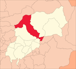
 Location of the district in the province of Húanuco |
|
| Basic data | |
| Country | Peru |
| region | Huánuco |
| province | Huánuco |
| Seat | Churubamba |
| surface | 552.3 km² |
| Residents | 15,670 (2017) |
| density | 28 inhabitants per km² |
| founding | October 4, 1921 |
| ISO 3166-2 | PE-HUC |
| Website | munichurubamba.gob.pe (Spanish) |
| politics | |
| Alcalde District | Elber Leandro Zuñiga (2019-2022) |
Coordinates: 9 ° 50 ′ S , 76 ° 8 ′ W
The Churubamba District is located in the Huánuco Province in the Huánuco Region in central Peru . The district was founded on October 4, 1921. It has an area of 552.27 km². In 2017 the population was 15,670. In 1993 the population was 16,570, in 2007 24,573. The administrative seat of the district is the village of Churubamba , which is about 1920 m high and has 446 inhabitants (as of 2017).
Geographical location
The district of Churubamba is located in the Peruvian Central Cordillera 15 km northeast of the regional capital Huánuco . The district has a longitudinal extension in NNW-SSE direction of 45 km. It stretches from the river valley of the Río Huallaga in the southeast to the Río Jarahuasi in the northwest and north.
The Churubamba district borders on the Santa María del Valle district to the west, the Marías district ( Dos de Mayo province ) to the northwest and north, the Chinchao district to the east and the Umari district ( Pachitea province ) to the south .
Individual evidence
- ↑ a b c PERU: Huánuco region - provinces and districts . www.citypopulation.de. Retrieved February 19, 2020.