Dos de Mayo province
| Dos de Mayo province | |
|---|---|
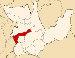
 Location of the province in the Huánuco region |
|
| Basic data | |
| Country | Peru |
| region | Huánuco |
| Seat | La Unión |
| surface | 1439 km² |
| Residents | 33,258 (2017) |
| density | 23 inhabitants per km² |
| founding | November 5, 1870 |
| ISO 3166-2 | PE-HUC |
| politics | |
| Alkalis | Luis Maldonado Rivera (2019-2022) |
| View of La Unión and Ripán | |
Coordinates: 9 ° 39 ′ S , 76 ° 43 ′ W
The province of Dos de Mayo ( Dos de Mayo Spanish for "May 2nd") is one of eleven provinces in the Huánuco department in central Peru . The province has an area of 1439 km². In the 2017 census, the population was 33,258. The capital of the province is La Unión .
Geographical location
The province of Dos de Mayo is located in the west of the Huánuco region. The Río Marañón flows through the province over a length of 15 km in a northerly direction and divides it into a western and an eastern part. The western part of the province extends over the catchment area of the Río Vizcarra and extends in the west to the Peruvian Western Cordillera . The eastern part of the province lies on the course of the Quebrada Huashpay , which flows into the Río Marañón, and on the upper reaches of the Río Jarahuasi , a tributary of the Río Huallaga . The mountains of the Peruvian Central Cordillera rise in the eastern part of the province.
structure
The province of Dos de Mayo is divided into nine districts. The district of La Unión is the seat of the provincial administration.
| District | Administrative headquarters |
|---|---|
| Chuquis | Chuquis |
| La Unión | La Unión |
| Marías | Marías |
| Pachas | Pachas |
| Quivilla | Quivilla |
| Ripan | Ripan |
| Shunqui | Shunqui |
| Sillapata | Sillapata |
| Yanas | Yanas |
Individual evidence
- ↑ Dos de Mayo, Province in Huánuco Region . www.citypopulation.de. Retrieved October 29, 2019.
