Cima Brenta Alta
| Cima Brenta Alta | ||
|---|---|---|
|
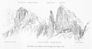
Cima Brenta Alta (far right), viewed from the west, drawing by Edward Theodore Compton |
||
| height | 2960 m slm | |
| location | Trentino , Italy | |
| Mountains | Brenta Group | |
| Notch height | 340 m ↓ Bocchetta del Campanile Basso | |
| Coordinates | 46 ° 9 '37 " N , 10 ° 53' 46" E | |
|
|
||
| Type | Felsberg | |
| rock | Main dolomite | |
| First ascent | August 19, 1880 by Annibale Appollonio and Giorgio Rossaro, led by Bonifacio and Matteo Nicolussi | |
The Cima Brenta Alta (Italian: Cima alta , high peak) is a 2960 meter high mountain in the Brenta Group , a mountain range in the southern Limestone Alps in the Italian province of Trento . It belongs to the so-called Sfulmini group , a series of needle- shaped or tower-shaped rock peaks that extend in a north-south direction. The mountain appears from northeast seen as a huge boulder, the high with its about 600 meters north-east wall, the area dominated . Like all the peaks of the Brenta, the Alta also consists of solid main dolomite rock, which makes it an attractive destination for climbers in particular ; numerous routes lead to the summit. The mountain was first climbed on August 19, 1880 by the Italian alpinists Annibale Appollonio and Giorgio Rossaro, led by the brothers Bonifacio and Matteo Nicolussi from Molveno . Due to its easy accessibility via the normal route , which is easy to climb , the Cima Brenta Alta is a popular destination from the Rifugio Tomaso Pedrotti (Pedrotti Hut).
geology
See: Crozzon di Brenta
Surroundings
The Cima Brenta Alta lies in the Sfulmini mountain range , which is bordered in the south by the Bocca di Brenta crossing (altitude 2549 m) and in the north by the Bocchetta di Molveno , which is at an altitude of 2746 meters. The highest neighboring mountain is in the south, beyond the Bocca di Brenta, the 2809 meter high Cima Brenta Bassa ( basso , low). Northern neighbors are the needle-shaped "bell towers" Campanile Basso and C. Alto , 2877 and 2937 meters high. To the east the terrain slopes down into the Val delle Seghe , to the south into the Val d'Ambiéz and to the west into the Val Brenta . Nearest towns are in the northwest, the well 7.5 km in a straight line away Madonna di Campiglio in Campigliotal , in the southeast, the about 6.5 km away is Molveno on Lake Molveno and about 12 km to the south, San Lorenzo in Banale .
Bases and routes
Today's normal route , the easiest climb, follows the first climbers. The starting point is the Pedrotti Hut, located southeast of the Cima, at an altitude of 2,496 meters, to the west above Molveno. From the hut, path no. 318 leads up to Bocca di Brenta and then in a northerly direction up to a chimney at the entrance . In easy climbing with difficulty levels UIAA I and II , it goes over rubble terraces and the bands characteristic of the main dolomite rock to the summit in a walking time of, according to literature, two hours.
Serious climbing routes have been leading over the southern edge since the 1920s (UIAA V-, first ascent Miori and Prati 1926) and through the west face ( Steger route , UIAA III, Agostini and Steger 1928). In 1972, when technical climbing was widespread, Anghileri, Gogna and Rava climbed over the northeastern edge to the summit of the Cima Brenta Alta. They set 85 rock hooks in the vertical, 470 meter high route. More challenging climbs can be found on the northeast face.
Literature and map
- Karl Schulz in Eduard Richter (ed.): The development of the Eastern Alps , III. Volume, Berlin 1894
- Heinz Steinkötter: Alpine Club Leader Brenta Group , Munich 1988, ISBN 3-7633-1311-7
- Alpine Club Map 1: 25,000, sheet 51, Brenta group

