Corvallis (Oregon)
| Corvallis | |
|---|---|
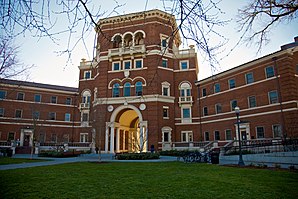
 Weatherford Hall in the Oregon State University Historic District |
|
| Location in county and state | |
| Basic data | |
| Foundation : | 1845 |
| State : | United States |
| State : | Oregon |
| County : | Benton County |
| Coordinates : | 44 ° 34 ′ N , 123 ° 16 ′ W |
| Time zone : | Pacific ( UTC − 8 / −7 ) |
|
Inhabitants : - Metropolitan Area : |
54,462 (as of 2010) 89,385 (as of 2016) |
| Population density : | 1,547.2 inhabitants per km 2 |
| Area : | 35.7 km 2 (approx. 14 mi 2 ) of which 35.2 km 2 (approx. 14 mi 2 ) is land |
| Height : | 68.3 m |
| Postal code : | 97339 |
| Area code : | +1 (541) 766 |
| FIPS : | 41-15800 |
| GNIS ID : | 1140162 |
| Website : | www.ci.corvallis.or.us |
| Mayor : | Biff Trotter |
Corvallis [ kɔːrˈvælɪs ] is a city in Benton County in the US state of Oregon . The city had a population of 54,462 at the 2010 census . It is the county seat of Benton County and was registered as a city in 1857. Corvallis is home to Oregon State University with over 26,000 enrolled students.
The National Park Service has 43 structures and sites for Corvallis on the National Register of Historic Places (NRHP) as of December 25, 2018, including the Oregon State University Historic District .
sons and daughters of the town
- Harry Lane (1855-1917), politician
- Vance Tartar (1911–1991), biologist and embryologist
- Jolene Unsoeld (* 1931), politician
- Barbara Roberts (* 1936), politician
- Timothy J. Richmond (* 1948), molecular biologist
- Carl Edwin Wieman (* 1951), physicist and Nobel Prize winner
- Harley Jessup (* 1954), production designer and special effects artist
- Wayne Krantz (* 1956), guitarist
- JR Reed (* 1967), actor and musician
- Eyvind Kang (* 1971), composer and multi-instrumentalist
- Jordan Smotherman (born 1986), ice hockey player
- Madeleine Thompson (* 1990), soccer player
- Noah Seitz , cellist and music teacher
Web links
Commons : Corvallis, Oregon - Collection of pictures, videos, and audio files
Individual evidence
- ↑ Search mask database in the National Register Information System. National Park Service , accessed December 25, 2018.
