
Dâmbovița (river)
| Dâmbovița | ||
 Dâmbovița |
||
| Data | ||
| location | Districts Argeș , Dâmbovița , Ilfov , Călărași , City of Bucharest ( Romania ) | |
| River system | Danube | |
| Drain over | Argeș → Danube → Black Sea | |
| source | in the Făgăraș Mountains ( Argeș County ) 45 ° 29 ′ 54 ″ N , 24 ° 56 ′ 14 ″ E |
|
| Source height | 2100 m | |
| muzzle | At Budești ( Călărași district ) in the Argeș coordinates: 44 ° 13 ′ 40 " N , 26 ° 28 ′ 14" E, 44 ° 13 ′ 40 " N , 26 ° 28 ′ 14" E |
|
| Mouth height | 20 m | |
| Height difference | 2080 m | |
| Bottom slope | 8.8 ‰ | |
| length | 237 km | |
| Catchment area | 2837 km² | |
| Left tributaries | Colentina | |
| Reservoirs flowed through | Pecineagu | |
| Big cities | Bucharest | |
| Small towns | Budeşti | |
| Communities | Rucăr , Dragoslavele , Stoeneşti , Cetățeni , Cândeşti , Vulcana-Băi , Tătărani , Dragomireşti , Lucieni , Nucet , Lungulețu , Dragomireşti-Vale , Cernica , Plătăreşti , Vasilați | |
 The Dâmbovița in Romania |
||
The Dâmbovița ( ) is a left tributary of the Argeș in Romania .
Its two source rivers, the Râul Valea Vladului and the Râul Boarcășu , arise in the Făgăraș Mountains and in the Iezer-Păpușa Mountains . On the upper reaches, on the area of the municipality of Dâmbovicioara , the river is dammed with the 105 meter high and 276 meter long Pecineagu dam ( ⊙ ). The Dâmbovița near Pucioasa forms another reservoir , then the Dridu reservoir at Fierbinți-Târg and before it flows through the capital Bucharest with the reservoir Lacul Morii , it flows into the Argeș river near Budeşti in the Călărași district .
photos
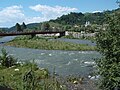
Dâmbovița at Malu cu Flori
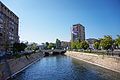
Dâmbovița in Bucharest

Dâmbovița Canal


Web links
Commons : Dâmbovița - collection of images, videos and audio files
- Article Dâmbovița in the Great Soviet Encyclopedia (BSE) , 3rd edition 1969–1978 (Russian)
Individual evidence
- ↑ Information on the dam and lake Pecineagu from muscelpedia.ro accessed on August 18, 2018 (Romanian)