
Dättnau
 district of Winterthur |
|
|---|---|
 |
|
| Coordinates | 694 471 / 260 068 |
| height | 479 m |
| surface | 2.78 km² |
| Residents | 3512 (Dec. 31, 2019) |
| Population density | 1263 inhabitants / km² |
| BFS no. | 230-420 |
| Post Code | 8406 |
| Urban district | Töss (District 4) |

Dättnau is a district of the city of Winterthur with 3,500 inhabitants. In addition to the actual Dättnau, the district also includes the Steig settlement, a settlement consisting of a few prefabricated buildings on Steigstrasse towards Brütten. Together with the Schlosstal , Eichliacker and Rossberg quarters, the quarter forms urban district 4 ( Töss ).
geography
Geographical location
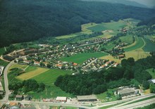
Dättnau is located on the southwestern outskirts of Winterthur in a side valley in a slightly elevated position southwest above Töss. It is almost completely enclosed by forest: in the southwest of the Dättnauerberg and in the north of the Ebnet , which encloses the quarter with a narrow spur to the east. In the north-west there is the Dättnauerweiher in a former gravel pit, which has made a name for itself through fossil deposits . Together with its immediate surroundings, this forms a nature reserve. Most of the built-up part of the quarter is located on a slope sloping to the southwest.
The independent Steig settlement is located in a clearing on Zürcherstrasse in the direction of Brütten and consists of seven apartment blocks, three with 8 floors and four with 4 floors. The quarter also includes the car garages and the music store near the Steigmühle between Steig and Dättnau.
geology
The Dättnauertal was formed when the glaciers retreated in the last ice age 18,000 years ago. The meltwater from the retreating glaciers ate its way into the freshwater molasse layer and a 170 meter deep valley was created. As the glacier retreated further, it became a dry valley . The moraine material left behind on the slopes of the glacier slowly slipped into the valley floor and filled the valley again by 50 meters. The top layer of about 10 meters was enriched with clay .
12,400 years ago, the valley was birch forested, but relatively quickly from pine into the underbrush were displaced. However, this forest disappeared again 10,800 years ago when another cold spell began. After the cold phase, which lasted 800 years, the Dättnau was forested again in the same order. Again 1,000 years later, the pine forests had finally Book - oak mixed forests soft. These findings about the forest cover of the Dättnau could be made by the Keller Ziegeleien AG from 1968 to 1988 in the area of today's Dättnauerweiher as a result of fossil tree remains found during clay mining.
population
Dättnau is still a relatively young quarter and was only created in the middle of the 20th century. Previously there were only farms and vines in this side valley. Since the construction of the Rieter workers' housing estate in the 1940s, the population in the quarter has increased rapidly and Dättnau is still one of the city's main development areas.
At the end of 2011, Dättnau had exceeded the 3,000-inhabitant mark, of which 800 inhabitants are in the Steig settlement. There are striking socio-cultural differences between the Steig settlement and the rest of Dättnau. Steig is a prefabricated housing estate from the 1960s with a proportion of foreigners of over 55% (2007) with many people from the same language area and from low-income groups. This difference is also evident in the level of education: while in Steig 51.7% have an elementary school certificate as the highest educational qualification, in the rest of Dättnau there are significantly fewer with 20.8% (2005) who have only completed compulsory elementary school.
Seen across the whole of Dättnau, the district has an average of 36.7% foreigners (2016), this value is slightly higher than the average for the city as a whole, but below the proportion of foreigners in the rest of the city district. Dättnau and Steig are popular with families, so the quarter has one of the highest proportions in the city with a child and youth quota of 25% (2016) - 5% higher than the municipal average. The number of one-person households is correspondingly low, in Dättnau (without Steig) it is just 6.9% (2005). In the municipal social monitoring published in 2016, which is based on income data, employment and social welfare status, among other things, the district is within the Winterthur average.
coat of arms

The blazon of the coat of arms reads: "In blue a silver, erect bear". This is the traditional coat of arms of the von Dättnau knight family. Dättnau was allowed to wear this coat of arms in 1990 by the city of Winterthur.
In addition to this official coat of arms there is, however, a second version, which has been handed down by Anders Edlibach and on the Gyger map (see picture) as a coat of arms divided three times to the left in red and silver.
education
There are three kindergartens and a primary school in the neighborhood, which together form the Laubegg school unit within the Töss primary school, named after the primary school. These include the Laubegg primary school, the Dättnau kindergarten, which is right next to the school building, and the “am Weiher” kindergarten at the Dättnau bus terminus. There is also its own kindergarten in the Steig.
The high school for all of Töss is the Rosenau schoolhouse in the Eichliacker quarter , which can be reached by the students either by bus, bike or on foot. The secondary canton schools can be found in the city center.
history
It is believed that the Alemanni first built a farm in today's Dättnau in the 6th century. The name Dättnau itself can be derived from Tattinowa, which in turn means something like the Au des Tatto. It can therefore be assumed that the land on which the first farm was built belonged to a certain Tatto.
In the Middle Ages, on June 9, 1271 or 72, a "Knight of Dättnau" is mentioned for the first time, who belongs to the Habsburg ministries . This is then probably the same as the one handed down from 1282 to 1288 as the knight Peter von Dättnau , who lived in a Weiherburg or swamp castle in the form of a residential tower ( Burg Dättnau ) near the intersection between the Brüttemer footpath and the then Dättnauerstrasse, which already existed in Roman times should have. Peter von Dättnau was Ammann von Zug from 1282 to 1294 . Also known is his son Welti von Dättnau , who in 1339 was one of the citizens of Zurich who captured and kidnapped the knights Wisso, Heinrich Stagel and their allies when the Zurich guild constitution was introduced in 1336. He is also the last known representative of the von Dättnau family. In the 13th century, above the Dättnau, on a spur of the terrain of the Dättnauerberg, was the Buch castle , seat of the Brütten family of miners, who were followers of the Einsiedeln monastery.
The court settlement of Dättnau, first mentioned in the 13th century, consisting of two courtyards, was sold to the Töss monastery on December 16, 1272 by the Habsburg ministerial Ulrich von Adlikon. In the 1270s, the Töss monastery also bought the Lüchental farm, which grew hemp and flax and can be found in the documents until 1420. In addition, the nuns had a fish pond built in Dättnau. With the Reformation in 1525, the monastery was finally abolished and the management of its properties was taken over by the Töss Monastery Office. The municipality of Töss bought the Dättnau farm from him three years later for 3,000 pounds in order to offer its citizens agricultural land. After the purchase, the municipality issued a building ban for the Dättnau, only the construction of a barn was allowed to the local farmers. The opening only lost its importance after Napoleon's invasion in 1798. Soon afterwards, two new houses were built in Dättnau, but the residents of Dättnau were not citizens of the municipality of Töss. This circumstance led to the establishment of a separate civil parish in 1820. In 1850, 43 residents are recorded in Dättnau. The civil parish of Dättnau was unable to meet its obligations in the long run despite high taxes, so that it was repealed in 1874 and the corresponding tasks were taken over by the political municipality of Töss. 1896 built Keller-Liechti one to repeatedly existing brick hut in a to repeatedly operated still with steam brickworks, which operated in what is now Dättnauerweihers clay mining and delivered it also historically valuable insights on the vegetation during the Ice Age in Dättnau. In a lexicon from 1902, the Dättnau has 69 inhabitants in 11 houses.
The development of the area began in 1942 with the construction of workers ' apartments by the Rieter machine factory on Dammwiesenstrasse - in 1950 the quarter had around 250 residents thanks to the workers' settlement. Since then, the population of the quarter has grown steadily, which continues to this day. In 1959 a neighborhood association was founded, which from then on campaigned for the interests of the neighborhood. In the 1960s, the Steig Plattensiedlung was built in the spirit of compact building. Further milestones in the neighborhood's history were the establishment of the kindergarten in 1992 and the opening of a separate bus line to the up-and-coming neighborhood on May 23, 1993. The Laubegg primary school opened in 2001; However, as this was made smaller than originally planned after a budget cut by the bourgeois majority in the municipal council, it had to be expanded after only two years and today still has a lack of space, especially with regard to the constant growth of the quarter. This budget cut has increased the price of the school house many times over.
Culture and leisure

In Dättnau there is a BMX track which is used by Powerbike Winterthur and which was the venue for two European Championship races for the fifth time in 2011. The association produced several Olympic athletes. The local Hornussenclub has had its playing field and clubhouse in Dättnau since 1978 and currently plays in the third-class first division.
As a local recreation area, in addition to the forests that extensively surround the quarter, there is also the «Dättnauerweiher» nature reserve, which is located in a former gravel pit. Dättnau is also the starting point of a 5 km long nature trail with 12 information boards that leads from the Dättnau bus terminal to the Wülflingen train station . There is an adventure playground in the Steig and a leisure facility with a playground in Dättnau, which is used and rented out for events by the Dättnau-Steig district association. Between Steigmühle and Steig is the "Freizeitarena Steig" with a 400 meter long go- kart track and a children's paradise.
In terms of gastronomy, there is the “Cooking Fellows” club in Dättnau on Dättnauerstrasse, which is open every Friday evening, and at the Steigmühle with the “Mangalbasi”, the first Royal Döner restaurant .
economy

The Dättnau and the Steig are both residential areas without large industrial or commercial zones. Before the cellar brickworks in Dättnau began mining the clay in 1896, the valley was used for agriculture and there were vineyards on the steep slopes, which have now completely disappeared.
Today there are still several car dealerships in the Steigmühle and the Steigmühle music house, which houses rehearsal rooms for bands and business premises. At the former headquarters of the Keller Ziegeleien in Dättnau is the branch of a company active in the construction trade and two other SMEs are based in the residential area.
Transport links
The main line to Dättnau is bus line 5 (Technorama - HB - Dättnau) from Stadtbus Winterthur , which serves the district every quarter of an hour, in the evenings and on Sundays every half hour. The Steig settlement is served by line 11 (HB - Steig) and the regional bus 660 (HB - Brütten - Nürensdorf - Bassersdorf). At the weekend, Dättnau is served by the N66 night line (HB - Töss - Brütten - Nürensdorf - Bassersdorf - Lindau - Kemptthal).
The Dättnauerstrasse connects the Dättnau via Neuburg with Wülflingen . The Steig settlement is located on Zürcherstrasse, which leads up to Brütten . The Winterthur-Töss motorway junction on the A1 / A4 is in the immediate vicinity of the quarter.
A bicycle lift is provisionally drawn in the urban traffic concept , which should lead to Dättnau.
An important connection to Dättnau for pedestrians is the Auenrainstutz, which is the fastest connection to Töss on foot. It is also often used by cyclists, although there is a general driving ban on this route.
literature
- Niklaus Felix Johannes Kaiser: A late Ice Age forest in Dättnau near Winterthur / Switzerland . Ziegler Druck- und Verlags-AG , Winterthur 1979, p. 90 .
- Rainer Brambach: Dättnau, spring awakening in the clay pits . ZKB, Zurich 1995.
Individual evidence
- ↑ Michael Wiesner : Forest time: forests for Winterthur . Naturwissenschaftliche Gesellschaft Winterthur, Winterthur 1997, ISBN 3-9521356-0-7 , Chapter 4 ( waldzeit.ch [accessed on May 6, 2018]).
- ^ A b Sonya Kuchen, Johanna Brandstetter: Final report on the social space analysis Dättnau-Steig . Ed .: University of Applied Sciences St. Gallen . Rorschach September 1, 2012 ( stadt.winterthur.ch [PDF; 1.4 MB ; accessed on May 6, 2018]).
- ↑ a b Katharina Prelicz-Huber , Hanspeter Hongler, Markus Kunz, Richard Wolff (geographer) , Jonas Fricker : Participatory district development Winterthur-Töss . Report to the city council. Winterthur / Zurich / Lucerne March 2006 ( stadt.winterthur.ch [PDF; 822 kB ; accessed on May 6, 2018]).
- ↑ Statistical quarterly mirror 2017. (PDF; 1.23 MB) (No longer available online.) City of Winterthur, urban development, archived from the original on February 19, 2017 ; accessed on May 6, 2018 . Info: The archive link was inserted automatically and has not yet been checked. Please check the original and archive link according to the instructions and then remove this notice.
- ↑ Till Hirsekorn: In which Winterthur neighborhoods the social burden increased and where it sank. In: landbote.ch. May 6, 2016. Retrieved August 11, 2016 .
- ↑ a b c Regina Speiser: Once there was clay, then the rubbish stank: Cover closed, house on . In: De Tössemer . 43rd volume, no. March 1 , 2000.
- ↑ a b Dr. Emil Stauber: The castles of the Winterthur district and their families (= New Year's Gazette of the City of Winterthur . No. 285 ). Winterthur 1953, p. 49−51 .
- ↑ Article "From Thosa to Töss, from Crugental to Chrugeler" by Henry Müller in Tössemer from June 2011.
- ↑ a b Walter Bossert: Inauguration of the new streets in Dättnau . In: Euses Blättli . 22nd year, no. 86 , September 2008 ( daettnau.ch [PDF; 8.1 MB ; accessed on May 6, 2018]).
- ^ Emil Stauber: History of the community of Töss (= New Year's Gazette of the City of Winterthur . No. 240 ). Buchdruckerei Geschwister Ziegler, Winterthur 1926, p. 54-55; 60-61 .
- ^ Marie-Claire Däniker-Gysin: History of the Dominican convent Töss 1233-1525 (= New Year's Gazette of the City of Winterthur . No. 259 ). 1958, p. 90-91 .
- ↑ Silvia Volkart: A journey through time to old Dättnau . In: Euses Blättli . 30th year, no. 117 , September 2016, p. 18–20 ( daettnau.ch [PDF; 2.5 MB ; accessed on May 6, 2018]).
- ↑ Meinrad Suter: Töss (community). In: Historical Lexicon of Switzerland .
- ^ Archive guide of the Canton of Zurich, article on Töss, documents on parchment of the former municipality of Töss (kept in the Winterthur City Archives)
- ^ Emil Stauber: History of the community of Töss (= New Year's Gazette of the City of Winterthur . No. 240 ). Buchdruckerei Geschwister Ziegler, Winterthur 1926, p. 220 .
- ^ Emil Stauber: History of the community of Töss (= New Year's Gazette of the City of Winterthur . No. 240 ). Buchdruckerei Geschwister Ziegler, Winterthur 1926, p. 2 .
- ^ Charles Knapp, Maurice Borel, Victor Attinger, Heinrich Brunner, Société neuchâteloise de geographie (editor): Geographical Lexicon of Switzerland . Volume 1: Aa - Emmengruppe . Verlag Gebrüder Attinger, Neuenburg 1902, p. 584 f., Keyword Dättnau ( scan of the lexicon page ).
- ↑ Roger Tacheron: Expensive reworking in «Laubegg» . In: The Landbote . March 11, 2004.
- ↑ Dättnau-Wülflingen nature trail. City of Winterthur, accessed on August 14, 2018 .
- ^ Website of the Cooking Fellows
- ↑ Martin Gmür: So that buses soon roar over boulevards . In: The Landbote . 17th August 2011.