Döbritschen (Dornburg-Camburg)
|
Dobrich
City of Dornburg-Camburg
Coordinates: 51 ° 2 ′ 39 ″ N , 11 ° 40 ′ 30 ″ E
|
|
|---|---|
| Height : | 125 m above sea level NN |
| Incorporation : | October 1, 1967 |
| Incorporated into: | Camburg |
| Postal code : | 07774 |
| Area code : | 036421 |
|
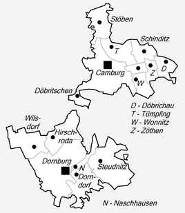
Location of Döbritschen in Dornburg-Camburg
|
|
|
Dobrich
|
|
Döbritschen is a district of the city of Dornburg-Camburg in Thuringia .
geography
The hamlet is located on the western bank of the Saale , at the foot of the Rodeberge , about two kilometers southwest of Camburg . To the south of the locality is the place Wichmar and its district Würchhausen . The floodplain is alluvial land of the Saale. With their wooded steep slope of about 100 meters high, the Rodeberge mark an east-facing bend in the river Saale. On the slopes there is shell limestone , which is overlaid on the heights of the loess plateau . One speaks of degraded black earth-like soils. The Naumburg – Camburg – Jena railway line runs through the corridor.
history
The place was first mentioned in a document in 1219. Some of the ministerials who named themselves after the place were subordinate to the Reich, later increasingly to the Margraves of Meissen. The aristocratic Münch family appeared here from the 14th century. For the first time, residents are mentioned by name around 1420. During the Count's War in the middle of the 14th century, the place and the castle were destroyed.
The manor with 96 hectares of farmland was managed by Albin Gellert in 1923. Döbritschen belonged to the Wettin office of Camburg at the latest in the 14th century , which due to several divisions in the course of its existence belonged to various Wettin duchies . From 1922 to 1939 the place belonged to the Camburg district department .
After the Second World War it was subject to the laws of agricultural development in the Soviet Zone and GDR. Now the property is privately owned again.
Environment, nature and economy
Immediately on the site of the hydropower plant , which was put back into operation after a general renovation, there is a fish ladder at the weir to protect the fish stocks . For the increasing tourism along the Saale, a tent and rest area was created on the river bank. Guided tours are organized by the Heimatverein. The meadow landscape south of Camburg still offers orchards with many old trees and rare animal and plant species.
Individual evidence
- ↑ Official topographic maps of Thuringia 1: 10,000. LK Weimarer Land, Saale-Holzland-Kreis, district-free cities Weimar and Jena (= CD-ROM series Top10 . CD 4). Thuringian Land Surveying Office, among others, Erfurt 1999, ISBN 3-86140-286-6 .
- ↑ Otto Dobencker [edit.]: Regesta diplomatica nec non epistolaria historiae Thuringiae, Vol. 2: 1152-1227, Jena 1900, No. 1849.
- ^ Andrei Zahn: The inhabitants of the offices of Burgau, Camburg and Dornburg. A prayer register from around 1421–1425 (= AMF series of publications. 55). Printed as a manuscript. Working Group for Central German Family Research, Mannheim 1998.
- ↑ Jürgen Gruhle: Black Book of Land Reform Thuringia. Internet, 2011
- ^ Johann Ernst Fabri : Geography for all estates. Part 1, Volume 4: Which contains the continuation and the resolution of the Upper Saxon Circle. Schwickert, Leipzig 1793, p. 224 f.

