Dümmer (nature reserve)
|
dumber
|
||
|
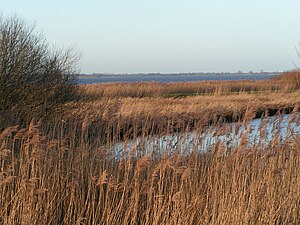
Reed zone on the south bank of the Dümmers |
||
| location | South of Diepholz and east of Damme , districts of Diepholz , Vechta and Osnabrück | |
| surface | 615.4 ha | |
| Identifier | NSG HA 024 | |
| WDPA ID | 81558 | |
| FFH area | 615 ha | |
| Bird sanctuary | 611.3 ha | |
| Geographical location | 52 ° 31 ' N , 8 ° 19' E | |
|
|
||
| Sea level | from 37 m to 38 m | |
| Setup date | March 22, 1952 | |
| administration | NLWKN | |
Dümmer is the name of a former nature reserve in the Lower Saxony municipalities of Lembruch and Hüde in the combined municipality of Altes Amt Lemförde in the district of Diepholz , the town of Damme in the district of Vechta and the municipality of Bohmte in the district of Osnabrück .
General
The nature reserve with the registration number NSG HA 024 was 615.4 hectares in size. Of this, 550.1 hectares were in the Diepholz district, 54.7 hectares in the Vechta district and 10.6 hectares in the Osnabrück district. The former nature reserve was for the most part part of the FFH area “Dümmer” and the EU bird sanctuary “Dümmer”. The former nature reserve borders in the north on the nature reserve " Huntebruch and Huntebruchwiesen ", in the west on the nature reserve " Westliche Dümmerniederung " and in the south on the former nature reserve " Ochsenmoor ". To the east it borders on the landscape protection area "Dumber". The area has been under nature protection since March 22, 1952. With the ordinance of December 14, 2007, an approximately 125 hectare part of the “Dümmer” nature reserve, which overlapped with the “Westliche Dümmerniederung” nature reserve, was deleted. The area remained part of the "Westliche Dümmerniederung" nature reserve. On August 16, 2019, the area was added to the newly designated nature reserve “Dümmer, Hohe Sieben and Ochsenmoor”. Responsible lower nature conservation authorities were the districts of Vechta, Osnabrück and Diepholz. Most of the lowland is protected by nature conservation law through the nature reserve “Dümmer, Hohe Sieben and Ochsenmoor”, the nature reserve “Westliche Dümmerniederung” and the nature reserve “Huntebruch and Huntebruchwiesen” .
The area was part of the LIFE-Nature project “Re-wetting of the western Dümmeniederung”, which was carried out from 2002 to 2007, aimed at upgrading the area for nature conservation and especially through the development of moist tall herbaceous vegetation and reeds.
description
The former nature reserve is located in the west of the Dümmers and includes areas of water as well as the banks of the Dümmers up to the dike surrounding the lake. In the Dümmer there are partly extensive floating leaf carpets made of pond and water lilies near the shore. The bank areas are occupied by reed zones.
The area where the Hunte flows into the Dümmer and the area near the Olgahafen in Dümmerlohausen were not in the nature reserve . The boundary between the former nature reserve and the navigable part of the Dümmers is marked by buoys, easily recognizable for boaters.
The lake and the meadow landscape surrounding it with extensive water areas and siltation zones and the adjacent wet grassland in the fens and swamp forests are particularly important habitats for meadow and water birds. So here are u. a. Lapwing , curlew , black-tailed godwit and common snipe as well as various ducks and walruses are native. Reeds and bushes are habitats for the reed warbler, reed bunting, reed swirl, bluethroat and nightingale.
At times of bird migration, numerous geese and ducks rest on the Dümmer, including table ducks, herons, whistling, gadgets, teal and shovelers.
Large parts of the area can be seen from the dike around the Dümmer. At its edge there are observation towers in the north, west and south.
Web links
- Nature conservation at Dümmer , North German Biotopes 19/04, Nature Conservation Association Lower Saxony / Biological Protection Association Hunte Weser-Ems / Nature Conservation Forum Germany (PDF; 176 kB)
- LIFE-Nature projects for rewetting the Dümmerniederung , Lower Saxony State Agency for Water Management, Coastal and Nature Conservation (PDF, 1.3 MB)
Individual evidence
- ↑ LIFE-Nature project "Re-wetting of the western Dümmerniederung" , Lower Saxony State Agency for Water Management, Coastal Protection and Nature Conservation . Retrieved October 10, 2019.
- ↑ Re-wetting , LIFE-Nature project “Re-wetting of the western Dümmerniederung”, Lower Saxony State Office for Water Management, Coastal Protection and Nature Conservation. Retrieved October 10, 2019.
- ↑ Dümmer-Ufer nature discovery trail (short distance): Bird concert at the lake , Geolife.de Navigator, State Office for Geoinformation and Land Surveying Lower Saxony . Retrieved October 10, 2019.
- ↑ a b observation tower on the north bank of the Dümmers , Geolife.de-Navigator, State Office for Geoinformation and Land Surveying Lower Saxony. Retrieved October 10, 2019.
- ↑ Observation tower on the west bank of the Dümmers , Geolife.de-Navigator, State Office for Geoinformation and State Surveying Lower Saxony. Retrieved October 10, 2019.
- ↑ Observation tower on the south bank of the Dümmers , Geolife.de-Navigator, State Office for Geoinformation and Land Surveying Lower Saxony. Retrieved October 10, 2019.


