Ox moor
|
Ox moor
|
||
|
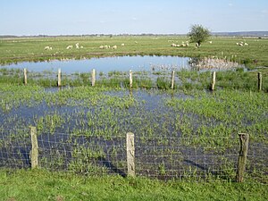
Ochsenmoor, viewed from the Huntedeich at the Schäferhof |
||
| location | South of the Dümmers , Diepholz district , Lower Saxony | |
| surface | 1,029 ha | |
| Identifier | NSG HA 172 | |
| WDPA ID | 164912 | |
| FFH area | 1,029 ha | |
| Bird sanctuary | 1,029 ha | |
| Geographical location | 52 ° 29 ′ N , 8 ° 19 ′ E | |
|
|
||
| Sea level | from 37 m to 39 m | |
| Setup date | February 16, 1995 | |
| administration | NLWKN | |
The Ochsenmoor is a former nature reserve in the Lower Saxony municipalities of Hüde , Marl and Stemshorn in the combined municipality of Altes Amt Lemförde in the Diepholz district .
General
The nature reserve with the sign NSG HA 172 was approximately 1,029 hectares . It was completely part of the FFH area “Dümmer” and the EU bird sanctuary “Dümmer”. The former nature reserve borders in the west on the nature reserve " Westliche Dümmerniederung " and in the north on the former nature reserve " Dümmer ". Furthermore, the nature reserve in the east borders in places, and to the west the sheep farm to the conservation area "Ochsenbruch". The area has been under nature protection since February 16, 1995. On August 16, 2019, the newly designated nature reserve "Dümmer, Hohe Sieben and Ochsenmoor" opened. The responsible lower nature conservation authority was the district of Diepholz. Most of the lowland is protected by nature conservation law through the nature reserve “Dümmer, Hohe Sieben and Ochsenmoor”, the nature reserve “Westliche Dümmerniederung” and the nature reserve “ Huntebruch and Huntebruchwiesen ” north of the Dümmer .
description
The former nature reserve is located south of the Dümmers and east of the Hunte in the Dümmerniederung. At the end of the 1980s, large parts of the ox bog were rewetted and significantly upgraded for nature conservation. The project was completed in 2000.
The area is characterized by fens with grassland used as pastures and hay meadows , wet and wet meadows, small and large sedge areas , reeds and occasional swamp forests . Central sections of the former protected area will be flooded with water until early summer. Parts of the nature reserve are grazed with sheep for care.
The lowlands is the habitat of various waders such as snipe , black-tailed godwit , redshank , curlew and lapwing and various songbirds , including Wagtail , Meadow Pipit , Whitethroat , black and Bluethroat , grasshopper warbler , skylark , marsh warbler and reed bunting . In addition, among other things, white stork and osprey home here.
The area is an important resting area for various Nordic geese , Limikolen and other migratory birds .
In the east of the former nature reserve, the Lower Saxony State Office for Water Management, Coastal and Nature Conservation has been operating a nature reserve station since 1993. There is also a nature trail here with an observation tower from which parts of the area can be viewed. Another observation tower is located on the dike in the south of the Dümmers.
Web links
- Through the Ochsenmoor to the lake , leaflet, Dümmer nature conservation station (PDF, 1 MB)
- LIFE-Nature projects for rewetting the Dümmerniederung , Lower Saxony State Agency for Water Management, Coastal and Nature Conservation (PDF, 1.3 MB)
Individual evidence
- ↑ The Ochsenmoor rewetting area is one of the largest wet meadow protection projects in Germany , Federal Agency for Nature Conservation , August 2013. Accessed on July 22, 2019
- ↑ LIFE-Nature project "Re-wetting of the western Dümmerniederung" , Lower Saxony State Agency for Water Management, Coastal Protection and Nature Conservation. Retrieved October 10, 2019.
- ↑ Ochsenmoor , Dümmer Nature Park e. V. Accessed July 22, 2019.
- ↑ a b c Dümmer Nature Experience Trail : Through the Ochsenmoor to the lake , Geolife.de Navigator, State Office for Geoinformation and Land Surveying Lower Saxony . Retrieved July 22, 2019.
- ↑ The Ochsenmoor , Naturschutzring Dümmer e. V. Accessed July 22, 2019.
- ↑ Nature conservation on site - The Dümmer nature conservation station , Lower Saxony State Agency for Water Management, Coastal and Nature Conservation. Retrieved July 22, 2019.
- ↑ Lookout tower on Ochsenmoor , Geolife.de-Navigator, State Office for Geoinformation and State Surveying Lower Saxony. Retrieved July 22, 2019.

