Dadra and Nagar Haveli
| Dadra and Nagar Haveli | |
|---|---|

|
|
| Union Territory | Dadra and Nagar Haveli and Daman and Diu |
| Administrative headquarters : | Silvassa |
| Area : | 491 km² |
| Residents : | 342,853 (2011) |
| Population density : | 698 inhabitants per km² Ew./km² |
| Website : | dnh.gov.in |
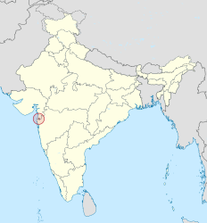
Dadra and Nagar Haveli ( Gujarati : દાદરા અને નગર હવેલી DADRA ane Nagar HAVELI ; port. : DADRA e Nagar Aveli ) is one of three districts of Union Territory Dadra and Nagar Haveli and Daman and Diu in India . It is located between the states of Gujarat and Maharashtra in western India and has 340,000 inhabitants (2011 census) on an area of 491 square kilometers. The administrative seat is in Silvassa . Dadra and Nagar Haveli was part of Portuguese India from 1780 to 1954, since 1961 it formed a union territory directly administered by the Indian central government. On January 26, 2020, it was merged with the Union Territory of Daman and Diu .
geography
location
Dadra and Nagar Haveli is located in western India between the states of Gujarat and Maharashtra around 130 kilometers north of Mumbai in the hinterland of the coast of the Arabian Sea . The district has an area of 491 square kilometers. It consists of two parts, Nagar Haveli and the much smaller Dadra, which is an exclave surrounded by the Gujarat area and only a few kilometers to the north. An enclave of Gujarat lies within Nagar Haveli . To the north, Dadra and Nagar Haveli is bordered by the Valsad district of Gujarat state, and to the south by the Thane district of Maharashtra state. Daman , also a former Portuguese colony and now the capital of the Union Territory, is only around 20 kilometers to the northwest, but is separated from Dadra and Nagar Haveli by a strip of land belonging to Gujarat.
topography
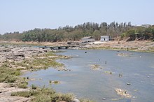
The area of Dadra and Nagar Haveli is slightly hilly. In the east, the terrain rises to the Western Ghats , but does not reach more than 300 meters above sea level. About 40 percent of the area is forested. The area is traversed by the Damanganga River, which is dammed up to form the Madhuban Reservoir.
Cities & Administration
Administratively, Dadra and Nagar Haveli form a single district and a single taluk (sub-district).
The only town in Dadra and Nagar Haveli is the capital Silvassa (21,890 inhabitants, 2001 census). Furthermore, 70 villages belong to Dadra and Nagar Haveli.
story
Dadra and Nagar Haveli is a former Portuguese colony. In a treaty concluded in Pune on January 6, 1780 , the Marathas left the area in the hinterland of the city of Daman , which had been under Portuguese rule since the 16th century, to the Portuguese as compensation for a pirate attack on a Portuguese ship. This made Dadra and Nagar Haveli part of Portuguese India .
After Indian independence, local nationalists took over power in a flash in July 1954 in Dadra and Nagar Haveli and created a pro-Indian administration. India refused to allow Portuguese troops at Daman to pass through Indian territory, so Portugal could not regain control of the area. On August 11, 1961, the nominally independent Free Dadra and Nagar Haveli became an Indian Union Territory. Shortly afterwards, in December 1961, India also brought the remaining Portuguese colonies ( Goa , Daman and Diu ) under its control by military means . The annexation of all these areas was only recognized by Portugal after the Carnation Revolution in 1974.
On January 26, 2020, Dadra and Nagar Haveli was merged with the Union Territory of Daman and Diu and was given the status of a district.
population
Demographics
According to the 2011 Indian census, the union territory of Dadra and Nagar Haveli had 342,853 inhabitants. The population density is 698 inhabitants per square kilometer. 46.6 percent of the residents of Dadra and Nagar Haveli live in cities. The population growth is significantly higher than in the surrounding areas, which is mainly explained by immigration from other areas of India. Between 2001 and 2011, the population of the Union Territory increased by 55.5 percent. Dadra and Nagar Haveli thus recorded the highest population growth of all Indian states and Union territories. The immigration of (predominantly male) labor migrants also explains the extremely unbalanced gender ratio: there are only 775 women for every 1,000 men in Dadra and Nagar Haveli. The literacy rate in Dadras and Nagar Havelis is 77.7 percent, which is the average for all of India.
The majority of the residents of Dadra and Nagar Havelis belong to the tribal population ( Adivasi ): The 2001 Indian census classified 62.2 percent of the inhabitants of the Union territory as members of the tribal population ( Scheduled Tribes ). The largest tribe is that of the Varli , who make up two thirds of the tribal population, followed by the Kokna and Dhodia .
Population development
| Census year | population |
|---|---|
| 1901 | 24,280 |
| 1911 | 29,020 |
| 1921 | 31,048 |
| 1931 | 38,260 |
| 1941 | 40,441 |
| 1951 | 41,532 |
| 1961 | 57,963 |
| 1971 | 74,170 |
| 1981 | 103,676 |
| 1991 | 138,477 |
| 2001 | 220,490 |
| 2011 | 343,709 |
languages
| Languages in Dadra and Nagar Haveli | ||||
|---|---|---|---|---|
| language | percent | |||
| Bhili | 40.4% | |||
| Gujarati | 23.7% | |||
| Hindi | 15.1% | |||
| Konkani | 10.4% | |||
| Marathi | 5.3% | |||
| Other | 5.1% | |||
| Distribution of languages (2001 census) | ||||
Different languages are spoken in Dadra and Nagar Haveli. The largest language is Bhili or Bhilodi, spoken among the tribal population , whose speakers make up 40 percent of the district's population. The Adivasi language Bhili belongs to the group of Indo-Aryan languages and is spoken in large parts of West India by a total of almost 10 million people as their mother tongue, but has not been written down. In addition, the languages of the neighboring federal states, Gujarati (24 percent) and Marathi (5 percent), as well as Hindi (15 percent) and Konkani (10 percent) are spoken in Dadra and Nagar Haveli . Immigrants from other parts of India speak numerous other languages, the speakers of which make up 5 percent of the population. English is used as the administrative language .
Religions
| Religions in Dadra and Nagar Haveli | ||||
|---|---|---|---|---|
| religion | percent | |||
| Hinduism | 93.9% | |||
| Islam | 3.8% | |||
| Christianity | 1.5% | |||
| Other | 1.7% | |||
| Distribution of religions (2011 census) | ||||
Among the residents of Dadra and Nagar Havelis, Hindus make up the vast majority with 94 percent (2011 census). There are also minorities of Muslims (4 percent) and Christians (1.5 percent).
Economy and Infrastructure
Dadra and Nagar Haveli has experienced strong industrialization since its annexation to India. Textiles, plastics, technical goods, chemicals and pharmaceuticals are produced. The Union territory benefited above all from the relatively low tax rates. The main line of business is still agriculture: According to the 2001 census, 47.5 percent of the working population work in the agricultural sector. The main crop is rice. In addition, forestry is carried out in the comparatively densely forested Dadra and Nagar Haveli.
Dadra and Nagar Haveli is not connected to the railway or trunk road network, but the National Highway 8 from Mumbai to New Delhi and parallel to it the railway line from Mumbai to Vadodara run directly to the west . The nearest train station is in Vapi, 18 kilometers northwest of Silvassa. There are currently plans to build an airport in Dadra and Nagar Haveli.
Web links
- Official website of Dadra and Nagar Haveli district
- Visitors Guide Daman, Diu, Dadra & Nagar Haveli (PDF; 426 kB)
Individual evidence
- ↑ Daman and Diu, Dadra and Nagar Haveli to be one Union Territory from January 26 , The Hindu, December 19, 2019, accessed March 23, 2020
- ↑ 2001 census ( Memento from June 16, 2004 in the Internet Archive )
- ^ The Imperial Gazetteer of India, Oxford 1908, Volume 11, p. 129.
- ^ Census of India 2011: Provisional Population Tables and Annexures ( Memento of January 10, 2012 in the Internet Archive ) and Provisional Population Totals - India - Rural-Urban Distribution. (PDF; 8.1 MB)
- ↑ population of D. & N.Haveli - StatisticsTimes.com. Retrieved June 3, 2019 .
- ↑ Indian census 2001
- ↑ Census of India 2011: Population by religious community.
- ^ Census GIS India. ( Memento of the original from January 11, 2010 in the Internet Archive ) Info: The archive link was inserted automatically and has not yet been checked. Please check the original and archive link according to the instructions and then remove this notice.
- ↑ Times of India : Proposal for airport at Nagar Haveli submitted, July 18, 2011.
Coordinates: 20 ° 16 ' N , 73 ° 1' E


