Darjeeling (district)
| Darjeeling district | |
|---|---|

|
|
| State | West Bengal |
| Division : | Jalpaiguri |
| Administrative headquarters : | Darjeeling |
| Area : | 3149 km² |
| Residents : | 1,846,823 (2011) |
| Population density : | 586 inhabitants / km² |
| Website : | darjeeling.gov.in |
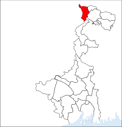
The district Darjeeling (also: Darjiling; Bengali : দার্জিলিং জেলা , Dārjiliṃ jelā ) is a district in the Indian state of West Bengal with 1.85 million inhabitants (2011) on an area of 3149 km². It borders the countries of Nepal , Bhutan and Bangladesh , the Indian states of Bihar and Sikkim and the West Bengal districts of Uttar Dinajpur and Jalpaiguri . The district capital is Darjeeling .
The largest cities are Kalimpong , Kursong and Shiliguri , with Shiliguri being by far the largest. The place Mirik is the most significant for tourism.
The town of Naxalbari is located in the Darjeeling district , where a Maoist- inspired peasant revolt took place in 1967 , which is considered the starting point for the Naxalite movement. The majority of the population is made up of Nepalese-born Gurkha . Several competing separatist movements have been active in the district for decades, and especially in the 1980s they advocated an autonomous Gorkhaland . Political slogans demanding the independence of Gurkhaland from West Bengal, as well as the green, white and yellow tricolor of the separatists, have dominated most places in the region since the movement flared up again in the late 2000s.


