
Dawydowo (Moscow, Orechowo-Sujewski)
| Village
Davydovo
Давыдово
|
||||||||||||||||||||||||||||||||||||||
|
||||||||||||||||||||||||||||||||||||||
|
||||||||||||||||||||||||||||||||||||||
| List of large settlements in Russia | ||||||||||||||||||||||||||||||||||||||
.png)
.gif)
.svg)

Dawydowo ( Russian Давы́дово ) is a village (derevnja) in Moscow Oblast in Russia with 10,918 inhabitants (as of October 14, 2010).
geography
The place is about 80 km as the crow flies east- south - east of the Moscow Oblast Administrative Center in an area called Guslizy , a settlement focus of the Old Orthodox who remained in central Russia after the 18th century . Not far from the village flows the Nerskaya , a left tributary of the Moskva .
Dawydowo belongs to the Orechowo-Sujewski Rajon and is located just 25 km south-southwest of its administrative center Orechowo-Sujewo and 5 km northwest of the city of Kurovskoye . The village is the seat of the rural community Davydovskoye selskoje posselenije, which also includes the villages of Anziferowo (7 km south-southwest), Barskoye (2 km north), Gora (adjoining to the west), Yakovlevskaya (6 km south-west), Yelisarowo (2 km west), Kostino (4 km southwest), Lyachowo (north-west adjoining) and Saponorje (4 km north) belong.
history
The place was first mentioned in 1631. The name is derived from the Russian form of the given name David . In the second half of the 19th and beginning of the 20th century, the village was also called Vosdwischenskoje (from Russian Vosdwischenije for Exaltation of the Cross ) after the name of the church there . The village experienced an economic boom from the end of the 19th century after a weaving and dyeing mill had opened there in 1890 and a mechanical factory in 1906.
From 1978 the factory was re-profiled and greatly expanded to become a plant for agricultural machinery . As a result, the population of the place increased significantly in the course of the 1980s, but it has retained its status as a village to this day. Davydovo was in the census of 2010, the third largest town in Russia with the usual mostly for smaller villages Status Derevnya after Watutinki , also in the Moscow Oblast, the but with the incorporation to Moscow as part of the community in 2012 (posselenije) Dessjonowskoje lost its independence, and Novoye Devyatkino in Leningrad Oblast .

Old Orthodox Chapel in Davydovo
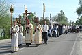
Old Orthodox Cross Procession in Dawydowo (Easter 2008)

Memorial stone for the victims of the Stalin Purges

Davydovo Railway Station


Population development
| year | Residents |
|---|---|
| 2002 | 10,694 |
| 2010 | 10,918 |
Note: census data
traffic
Dawydowo is located on the regional road 46K-7303, which branches off the A108 ("Big Moscow Ring") at Kurowskoje and leads to Pavlovsky Posad , where there is a connection to the M7 to the north .
To the east of the village is the Dawydowo railway station on the Great Moscow Railway Ring , which opened on this section in 1899 (route km 105 from Schiljowo near Stupino ), which crosses the Moscow - Kazan - Yekaterinburg railway at neighboring Kurovskoye . On the ring there is a continuous suburban train connection in the north via Orechowo-Sujewo to Alexandrow , in the south to Michnewo and Schiljowo.
Web links
- Official website of the local government (Russian)
Individual evidence
- ↑ a b Itogi Vserossijskoj perepisi naselenija 2010 goda. Tom 1. Čislennostʹ i razmeščenie naselenija (Results of the All-Russian Census 2010. Volume 1. Number and distribution of the population). Tables 5 , pp. 12-209; 11 , pp. 312–979 (download from the website of the Federal Service for State Statistics of the Russian Federation)