Ayacucho district
| Ayacucho district | |||
|---|---|---|---|
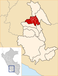
 Ayacucho district is located in the central north of Huamanga Province (marked in red) |
|||
| Symbols | |||
|
|||
| Basic data | |||
| Country | Peru | ||
| region | Ayacucho | ||
| province | Huamanga | ||
| Seat | Ayacucho (Huamanga) | ||
| surface | 71.5 km² | ||
| Residents | 99,427 (2017) | ||
| density | 1391 inhabitants per km² | ||
| ISO 3166-2 | PE-AYA | ||
| Website | www.munihuamanga.gob.pe (Spanish) | ||
| politics | |||
| Alcalde Provincial | Yuri Alberto Gutiérrez Gutiérrez (2019-2022) |
||
| Political party | Musuq ñan | ||
| View of the city center of Ayacucho (Huamanga) | |||
Coordinates: 13 ° 9 ′ 37 ″ S , 74 ° 13 ′ 30 ″ W
The Ayacucho district is located in the Huamanga Province in the Ayacucho region in south-central Peru . The district has an area of 71.5 km². The 2017 census counted 99,427 residents. The district administration is located in the provincial and regional capital Ayacucho (Huamanga) with 95,371 inhabitants, at an altitude of 2746 m .
Geographical location
The Ayacucho district is located in the eastern Andean highlands in the central north of the Huamanga Province.
The Ayacucho district is bordered on the southwest by the district Socos , in the northwest of the district of San José de Ticllas in the far north to the district Pacaycasa , on the east by the districts of Jesus Nazareno , Andrés Avelino Cáceres Dorregaray and San Juan Bautista and the southeast by the Carmen Alto District .
Individual evidence
- ↑ Peru: Ayacucho - Provinces & Districts . www.citypopulation.de. Retrieved April 15, 2020.


