Socos District
| Socos District | |
|---|---|
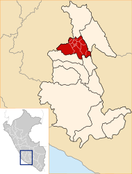
 The Socos district is located in the central west of the Huamanga Province (marked in red) |
|
| Basic data | |
| Country | Peru |
| region | Ayacucho |
| province | Huamanga |
| Seat | Socos |
| surface | 82.1 km² |
| Residents | 6328 (2017) |
| density | 77 inhabitants per km² |
| founding | June 14, 1968 |
| ISO 3166-2 | PE-AYA |
| politics | |
| Alcalde District | César Meneses Huayanay (2019-2022) |
| Political party | Desarrollo integral Ayacucho |
Coordinates: 13 ° 12 ′ 54 ″ S , 74 ° 17 ′ 22 ″ W.
The Socos district is located in the Huamanga Province in the Ayacucho region in south-central Peru . The district was established on June 14, 1968. It has an area of 82.1 km². The 2017 census counted 6,328 inhabitants. In 1993 the population was 6365, in 2007 it was 6903. The district administration is located in the 3400 m high town of Socos with 578 inhabitants (as of 2017). Socos is 9 km southwest of the provincial and regional capital Ayacucho (Huamanga).
Geographical location
The Socos district is located in the Andean highlands in the central west of the Huamanga province. It has a length in north-south direction of almost 29 km and a maximum width of 8.5 km. In the south, the district extends to the Río Matarayocc, a right tributary of the Río Cachi .
The Socos district is bordered to the west by the Vinchos , in the northwest of the district of San José de Ticllas , in the northeast on the district Ayacucho , on the east by the district Carmen Alto and on the southeast by the district Chiara .
Localities
In addition to the main town, there are the following larger towns in the district:
- La Merced Loyanta (361 inhabitants)
- Manzanayocc (277 inhabitants)
- Maucallacta (404 inhabitants)
- Paucho (209 inhabitants)
- San Rafael (441 inhabitants)
- Yanayacu (236 inhabitants)
Web links
- Peru: Ayacucho region (provinces and districts) at www.citypopulation.de
- INEI Perú