Tambillo District
| Tambillo District | |
|---|---|
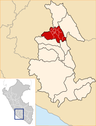
 The Tambillo district is located in the east of the Huamanga province (marked in red) |
|
| Basic data | |
| Country | Peru |
| region | Ayacucho |
| province | Huamanga |
| Seat | Tambillo |
| surface | 179 km² |
| Residents | 5047 (2017) |
| density | 28 inhabitants per km² |
| ISO 3166-2 | PE-AYA |
| Website | www.munitambillo.gob.pe (Spanish) |
| politics | |
| Alcalde District | Carlos Alfredo Cabrera Quispe (2019-2022) |
| Political party | Qatun Tarpuy |
Coordinates: 13 ° 12 ′ S , 74 ° 7 ′ W
The Tambillo District is located in the Huamanga Province in the Ayacucho region in south-central Peru . The district has an area of 179 km². The 2017 census counted 5047 inhabitants. In 1993 the population was 3642, in 2007 it was 5068. The district administration is located in the village of Tambillo, 3080 m above sea level, with 237 inhabitants (as of 2017). Tambillo is located 13 km east-southeast of the provincial and regional capital Ayacucho (Huamanga).
Geographical location
The Tambillo District is located in the east of the Huamanga Province. It is located in the Andean highlands on the western flank of the Peruvian Central Cordillera . The district extends between the rivers of the Río Huata in the west and the Río Yucay in the north.
The district of Tambillo borders in the southwest on the district Chiara , in the northwest on the districts San Juan Bautista , Andrés Avelino Cáceres Dorregaray and Jesús Nazareno in the north on the district Quinua , in the northeast on the district Acos Vinchos and in the east on the district Acocro .
Individual evidence
- ↑ a b Peru: Ayacucho - Provinces & Districts . www.citypopulation.de. Retrieved April 15, 2020.